Na 44 maanden projectduur, en met het einde in september 2026 in zicht, werden tijdens de algemene vergadering in Milaan de voortgang en de resultaten geëvalueerd die voortvloeiden uit de toepassing van de Safe Operating Space for Water in de proefgebieden van het project: de Rijn, de Donau, de Júcar en de Mekongdelta. Tijdens de consortiumbijeenkomst, en als onderdeel van de SOS-Water-seminarserie, gaven onderzoeksprofessoren Hector Macián-Sorribes en Manuel Pulido-Velázquez, beiden verbonden aan IIAMA-UPV, een webinar over het gebruik van watergerelateerde indicatoren als sleutelcomponenten voor de kwantificering van waterzekerheid en duurzaamheid op stroomgebiedniveau.
Tijdens de bijeenkomst kwamen verschillende aspecten aan bod met betrekking tot a) de integratie en communicatie van onzekerheid, b) de visualisatie van resultaten via een dynamisch, interactief en gebruiksvriendelijk webdashboard, c) de presentatie en communicatie van resultaten aan belanghebbenden via beleidsnota’s, en d) de exploitatie en duurzaamheid van de methodologie na afloop van het project.
Binnen zijn werkterrein, dat zich richt op het gebruik van satellietgegevens en de ontwikkeling van toepassingen en op aardobservatie gebaseerde diensten voor SOS-Water, presenteerde FutureWater samen met Eawag de basis waarop het volgende deliverable, “Aanbevelingen voor de promotie van Copernicus- en GEOSS-diensten”, zal worden gebaseerd. De belangrijkste belemmeringen en aanbevelingen die door het Europese Water-ForCE-project zijn ontwikkeld, werden besproken en de meningen van de deelnemers werden verzameld met betrekking tot het nut en het potentieel van satellietdiensten voor het verbeteren van de nauwkeurigheid van belangrijke indicatoren die worden gebruikt in de Operational Water Security Space op stroomgebiedniveau.
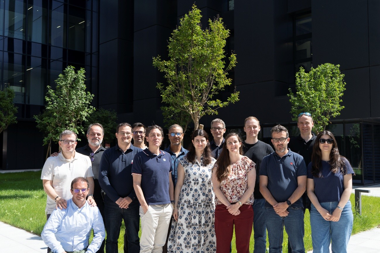
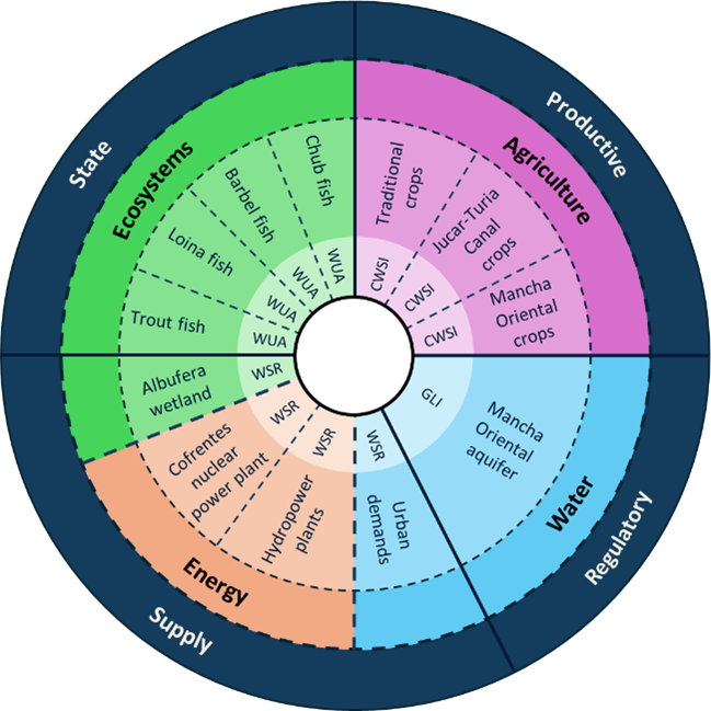
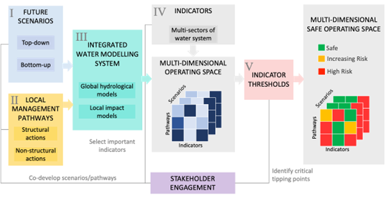
SOS-Water-leden die de consortiumbijeenkomst bijwoonden die van 20 tot 22 mei 2026 in Milaan werd gehoudenReeks aandachtsgebieden en indicatoren die worden gebruikt in de operationele ruimte voor waterzekerheid in het Júcar-bekken.Stroomschema van het SOS-Water-project dat wordt gebruikt om de operationele ruimte voor waterzekerheid op stroomgebiedniveau te definiëren en te kwantificeren.
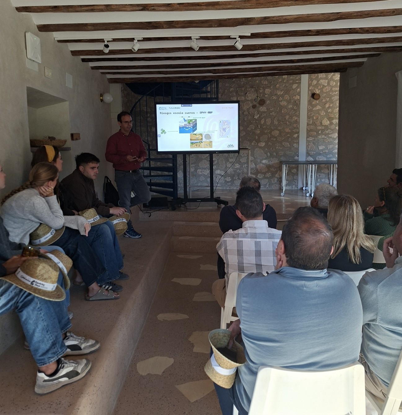
Op 6 mei speelde FutureWater een prominente rol tijdens het evenement „Solebromino Opening Days: Regenerate the land, Reimagine the future” (4–10 mei 2026, Huéscar – Spanje), dat een breed scala aan activiteiten omvatte rond regeneratieve landbouw en de „4-returns”-benadering als motor voor verandering en plattelandsontwikkeling in het hoogland van Granada.
Als onderdeel van de samenwerking met Solebromino leidde FutureWater een praktische veldworkshop en nam het deel aan een paneldiscussie met andere experts en belanghebbenden.
Tijdens de veldworkshop op de Cubero-boerderij van Solebromino benadrukte het FutureWater-team het belang van het ontwikkelen van een “Water Adaptation and Resilience Plan” om deze uitdaging aan te pakken. Dit plan moet gebaseerd zijn op vier sterke pijlers:
een uniform model voor gegevensbeheer,
een krachtige toolbox met modelleringsmogelijkheden,
een robuust opleidings- en capaciteitsopbouwprogramma, en
een veldmonitoring- en sensorsysteem om de “gezondheid” en de voortgang van de boerderij te meten. Deze vier pijlers vormen de basis voor een systeem dat in staat is om de traditionele kennis van onze omgeving te integreren met de meest geavanceerde wetenschap en technologie.
Tijdens de praktische sessie lieten onze collega’s Sergio Contreras en Amelia Fernández zien hoe we, door gebruik te maken van openbare gegevens, de productiviteit van onze boerderijen kunnen verbeteren door: a) het identificeren van potentiële en daadwerkelijke risico’s van verlies van vruchtbare grond, b) het nauwkeurig in kaart brengen van mogelijkheden voor wateropvang en -winning, en c) het beoordelen van hoe en wanneer regeneratieve praktijken moeten worden toegepast om de veerkracht van onze boerderij tegen extreme droogte en hevige regenval te verbeteren.
De praktische workshop werd afgesloten met een veldbezoek aan de Cubero-boerderij, waar alle deelnemers de voordelen konden zien van verschillende regeneratieve watergerelateerde praktijken die al door Solebromino zijn geïmplementeerd, waaronder infiltratiesloten en -vijvers, stenen muren, biodiversiteitsvijvers, herbeplantingsstroken in kwetsbare en aangetaste gebieden, en het onderhoud van eilandbossen.
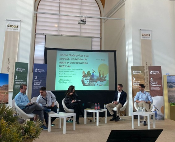
Tijdens de RegenTalks getiteld “Hoe een droogte te overleven. Praktijken voor waterwinning en waterbeheer”, gehouden in het iconische CICOS-gebouw in Huéscar, deelde Sergio met iedereen de internationale visie en ervaring van FutureWater met praktijken voor water- en landbehoud, op de natuur gebaseerde oplossingen en Payment for Ecosystem Services als nuttige instrumenten om de praktijken voor behoud en herstel te waarderen. Sergio benadrukte de belangrijkste uitdagingen en kansen voor boeren die zich willen inzetten voor veerkrachtigere en productievere agro-ecosystemen, zoals die welke voortvloeien uit klimaatverandering, de aantasting van productieve grond, het verlies van ontwikkelingskansen en menselijk kapitaal in plattelandsgebieden, het behoud van gekwalificeerde technici, en administratieve en institutionele belemmeringen, waarvan vele voortkomen uit een gebrek aan afstemming tussen ontwikkelings- en milieubeleid.
Wij danken Solebromino voor hun vertrouwen in het FutureWater-team. We hopen dat dit partnerschap het momentum blijft krijgen dat nodig is om aan te tonen dat regenafhankelijke landbouw in deze regio levensvatbaar, concurrerend en schaalbaar kan zijn.
Geïnteresseerd in het maken van een verschil, in de transformatie? Wij kunnen u ondersteunen; schrijf ons op s.contreras@futurewater.es
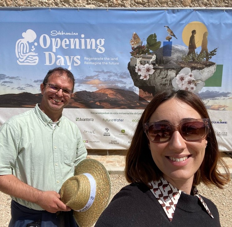
FutureWater tijdens de lezing en discussiesessie “Hoe een droogte te overleven: maatregelen voor waterwinning en waterbeheer” (Huéscar, 6 mei 2026).Sergio demonstreert de hydrologische simulatietools die worden gebruikt om hotspots van bodem- en waterverlies op te sporen (Huéscar, 6 mei 2026).Sergio Contreras en Amelia Fernández (FutureWater) tijdens de Solebromino Opening Days (Húescar, 4–9 mei 2026)
Onlangs is er een wetenschappelijk artikel gepubliceerd in Remote Sensing ( doi: 10.3390/rs17111855) waarin de geavanceerde technologie wordt gepresenteerd die is ontwikkeld door het MAGDA-project, dat meerdere sensorplatforms en modelleringsinstrumenten integreert om agrarische weersvoorspellingen en irrigatieadviezen te verbeteren.
Dit nieuwe onderzoek biedt een doorbraak in precisielandbouw door het combineren van gegevens van Europese satellieten, drones, grondsensoren en GNSS-signalen voor zeer lokale en nauwkeurige weer- en bodemvochtmonitoring.
Het MAGDA-systeem biedt aanzienlijke voordelen door weersvoorspellingen op korte termijn en irrigatieschema’s op veldschaal te verbeteren, waardoor de uitdagingen als gevolg van klimaatverandering en extreme weersomstandigheden worden aangepakt. Boeren krijgen toegang tot nauwkeurige informatie die helpt om het watergebruik te optimaliseren, verspilling tegen te gaan en gewassen beter te beschermen tegen droogte, overstromingen en hagelbuien.
Een belangrijk onderdeel van het MAGDA systeem is IrriSPHY-1D, een geavanceerd agrohydrologisch model dat door FutureWater wordt ondersteund en is ingebed in MAGDA’s irrigatieadviesdienst. IrriSPHY-1D simuleert nauwkeurig de bodemvochtdynamiek in de wortelzone van het gewas en berekent de irrigatiewaterbehoefte nauwkeuriger dan ooit tevoren. Deze verbeterde mogelijkheden stellen boeren in staat om de watergift te optimaliseren, verspilling tegen te gaan en de milieu-impact van irrigatiepraktijken te minimaliseren.
De integratie van MAGDA-datasets – waaronder atmosferische gegevens met hoge resolutie van Meteodrones, satellietbodemvocht en bodemvochtterugwinning via GNSS-reflectometrie – in IrriSPHY-1D verbetert irrigatieadviezen aanzienlijk. Dankzij deze gegevensfusie kan het systeem betrouwbaardere en beter uitvoerbare irrigatievoorspellingen doen, waardoor het waterbeheer en de veerkracht van de landbouw verbeteren.
Met deze innovatieve aanpak en wetenschappelijke validatie hebben FutureWater en MAGDA’s partners een belangrijke bijdrage geleverd aan het bevorderen van duurzame en klimaatbestendige landbouwpraktijken in heel Europa.
Op 8 en 9 oktober 2025 werd de2e jaarlijkse bijeenkomst van het MegaWat-project gehouden in het Instituut voor Wetenschap en Technologie Oostenrijk (Klosterneuburg). MegaWat is een internationaal initiatief gewijd aan de beoordeling van de impact van megadoorbraken op Europese hooggebergte gebieden. FutureWater, dat het werkpakket veerkracht en aanpassing leidt, presenteerde de voortgang van de evaluatie van de impact van megadoorbraken op de waterzekerheid van sneeuwafhankelijke watervoorzieningssystemen.
Tijdens de bijeenkomst deelden de partners de nieuwste ontwikkelingen in het genereren van extreme klimaatscenario’s met behulp van het CHELSEA-algoritme voor het schalen van klimaatforceringen, hydrologische modellering in hooggebergten met het T&C-model (Tethys-Chloris) en het karakteriseren van het gedrag van sneeuwsmeltafhankelijke stroomgebieden. MegaWat wordt toegepast in drie proefregio’s: de Pyreneeën (Aragón-Arga, Gállego en Cinca-Segre), de Apennijnen (Tiberbekken) en de Zwitserse Alpen, waardoor de effecten van megadroogte op de waterzekerheid kunnen worden beoordeeld.
FutureWater gaf een update van de status van de activiteiten in het Work Package on Resilience and Adaptation (WP4), met de nadruk op de vooruitgang in de karakterisering van de veerkracht voor het Spaanse Pyreneeën pilotproject. Hier wordt de WEAP tool gebruikt om risico’s te kwantificeren onder extreme droogte scenario’s zoals die zijn ervaren in Australië (1996-2010) en Chili (2010 en nu). Daarnaast heeft FutureWater de “Resilience Calculator” tool ontwikkeld en gaat het door met het verbeteren van InfoSequia om vroegtijdige voorspellingen te kunnen doen – essentieel voor efficiënt waterbeheer voor huishoudelijk, agrarisch en industrieel gebruik.
MegaWat bevindt zich momenteel in een tussenstadium. Tijdens de bijeenkomst werden toekomstige mijlpalen gedefinieerd die gericht zijn op het versterken van de overdracht van resultaten tussen teams, het vergroten van de betrokkenheid van belanghebbenden en het publiceren van bevindingen in wetenschappelijke tijdschriften met een hoge impact.
Het project MegaWat heeft financiering ontvangen van het Oostenrijks Wetenschapsfonds (FWF), de Zwitserse Nationale Wetenschapsstichting (SNSF), het Centrum voor de Ontwikkeling van Industriële Technologie (CDTI), de Nederlandse Onderzoeksraad (NWO), de Nationale Onderzoeksraad (CNR) en het Horizon Europe Programma van de Europese Unie in het kader van de gezamenlijke transnationale oproep 2022 van het Europese partnerschap Water4all (Grant Agreement n°101060874)
I-DIP is gebaseerd op InfoSequia, een geavanceerde toolkit die satellietgegevens, lokale waarnemingen en machine learning integreert om droogtes te monitoren en te voorspellen. Er zal een nieuwe indicator voor flitsdroogte, aangepast aan het Pakistaanse klimaat, worden ontwikkeld en geïntegreerd in het bestaande NDMC-systeem. Het project zal de mogelijkheden voor vroegtijdige waarschuwing verbeteren, de voedsel- en waterzekerheid waarborgen en bijdragen aan de nationale inspanningen voor klimaatadaptatie, waardoor de weg wordt vrijgemaakt voor de uitbreiding van het I-DIP in heel Pakistan.
Naast monitoring zal het I-DIP zijn voorspellingen koppelen aan besluitvormingsinstrumenten. Informatie over de gevolgen zal worden verspreid via nieuwsbrieven en de inFarmer-applicatie (ontwikkeld door WaterSprint), die al op grote schaal wordt gebruikt door boerengemeenschappen. Veldmedewerkers van het Better Cotton Initiative zullen deze kennis vertalen naar praktische richtlijnen voor boeren, zodat ze irrigatiepraktijken kunnen aanpassen, teeltkalenders kunnen bijstellen en potentiële verliezen kunnen beperken. Deze integratie van geavanceerde droogtewetenschap met gevestigde communicatienetwerken zorgt ervoor dat vroegtijdige waarschuwingen worden omgezet in praktische acties in het veld.
Door I-DIP te integreren in het operationele systeem van de NDMC versterkt het project direct de vroegtijdige waarschuwingscapaciteit voor droogte in Pakistan, sluit het aan bij het nationale klimaatbeleid en ondersteunt het de toezeggingen van het land in het kader van de Sustainable Development Goals. Op de lange termijn zal het proefproject naar verwachting de schaalvergroting van I-DIP in heel Pakistan katalyseren, waardoor de autoriteiten de beschikking krijgen over een geavanceerd instrument om te anticiperen op deze extreme gebeurtenissen en ze te beheersen.
FutureWater heeft de eerste fase afgerond van een baanbrekend toegepast onderzoeksproject ter ondersteuning van een veilige en veerkrachtige overgang in regeneratieve landbouw in afgelegen plattelandsgebieden in Zuid-Spanje.
Een veerkrachtige overgang in regeneratieve landbouw omvat een geleidelijke verschuiving van conventionele praktijken naar systemen die het behoud en herstel van bodem, water en biodiversiteit in agrarische landschappen bevorderen, terwijl de productie en winstgevendheid worden gestabiliseerd terwijl het systeem leert en zich aanpast aan klimaat- en marktschokken. Regeneratieve landbouw gaat niet alleen over het veranderen van praktijken: het is een paradigmaverschuiving die traditionele praktijken herstelt en in staat is te absorberen, aan te passen en te transformeren zonder te falen.
Het uiteindelijke doel van het project, dat begin 2025 van start ging en gefinancierd werd door een toonaangevend bedrijf in de sector, is om de landbouwgrond van het merk aan te passen om de agro-milieuwaarden te verbeteren door de effectieve implementatie van ingrepen die in staat zijn om water te behouden en bodemverliezen te voorkomen die typisch veroorzaakt worden tijdens hevige regenval. Het project evalueerde de effectiviteit van verschillende aanpassingsportfolio’s die berusten op de combinatie van hybride oplossingen met een lage impact en groene oplossingen (bijv. infiltratiegeulen, stenen bundels, biodiversiteitsvijvers of eilandbossen).
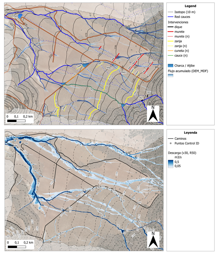
De demonstratiestudie werd uitgevoerd in een stroomgebied van de Guadalquivir in de regio Alvelal (Zuid-Spanje). Het recept van FutureWater maakt het mogelijk om de beste waterbeheerpraktijken in het veld toe te passen op basis van voorafgaande haalbaarheidsbeoordelingen die GIS- en simulatietools combineren die in staat zijn om hydrologische risico’s in het hele landschap te identificeren en te kwantificeren en de optimale locatie voor de meest kosteneffectieve veldinterventies te vinden. Het algemene kader dat aan boeren wordt aangeboden biedt analyses, richtlijnen en training voor: (1) het verzamelen en harmoniseren van ruimtelijke gegevens en het bouwen van hun eigen QGIS-projecten, (2) het identificeren van gebieden met een hoog risico op water- en bodemverlies, en (3) het analyseren van het hydraulisch gedrag van landbouwgronden en hun omgeving onder intense regenval, en de effectiviteit van enkelvoudige interventies of portfolio’s om risico’s te verminderen en milieugoederen te verbeteren (Figuur). Voor de ontwikkeling van dit proefproject en de onderdelen ervan werden gratis en open-source softwaretools gebruikt, waaronder QGIS. en hydrologische-bodemsimulatiemodellen zoals SPHY en SIMWE.
De resultaten van deze pilot/demo oefening zijn veelbelovend en inspirerend gebleken voor het versterken van regeneratieve regeneratieve landbouwinitiatieven in semi-aride omgevingen, en zeer nuttig voor het diagnosticeren van kwetsbaarheden en risico’s, evenals het plannen van veerkrachtige aanpassingsprogramma’s die zowel economisch als ecologisch duurzaam zijn.
In de loop van het project, dat met succes werd uitgevoerd in een periode van 6 maanden in een proefgebied van 350 ha, werden verschillende belangrijke resultaten opgeleverd, waaronder vier technische rapporten, een QGIS-project en een uitgebreide dataset met de resultaten van de hydrologische en hydraulische simulatieoefeningen.
Voor volgend jaar is een tweede fase van het project gepland, waarbij de nadruk ligt op het opschalen van de aanpak over het hele landbouwgebied, het omzetten van de simulatieworkflow in een gebruiksvriendelijke QGIS-plugin en het trainen van technisch personeel door middel van cursussen en praktijkoefeningen met de tools van het project.
Als je meer wilt weten, neem dan contact op met Sergio Contreras.
Kaart van geëvalueerde interventies (bovenste paneel) en voorspellingen van het SIMWE-model van het gestage debiet (m³/s) dat wordt bereikt door een maximale regenval van 50 mm/u (onderste paneel).
De technische ondersteuning is gebaseerd op modellering van watervoorraden, vroegtijdige waarschuwing voor droogte en teledetectie, en is gebaseerd op samenwerking met kennisinstellingen en beleidsstakeholders. Het werk omvat ook het evalueren van de huidige praktijken in de lidstaten, het beoordelen van de ecologische en sociaaleconomische effecten en het identificeren van gebieden die voor verbetering vatbaar zijn. Door middel van deze inbreng ondersteunt FutureWater de Commissie bij het aanpakken van complexe vraagstukken rond waterbestendigheid en zorgt er tegelijkertijd voor dat wetenschappelijke bevindingen worden vertaald in bruikbare inzichten voor beleid en planning.
De aanpak van FutureWater en Galayr is zowel wetenschappelijk rigoureus als contextueel onderbouwd, zodat het ontwikkelde droogtemodel lokaal relevant, duurzaam en volledig geïntegreerd is in bestaande nationale systemen zoals die van SODMA en NADFOR. In het model worden top-down (gegevensgestuurd, met behulp van machinaal leren) en bottom-up (op basis van informatie van belanghebbenden) benaderingen gecombineerd, waarbij satellietgegevens, klimaatindices en inheemse kennis worden gecombineerd om gezamenlijk op impact gebaseerde voorspellingen en op consensus gebaseerde triggers voor anticiperende actie te ontwikkelen.
Voor de ontwikkeling van het droogtevoorspellingsmodel en de kennisoverdracht richten we ons op de volgende pijlers:
Een gefaseerd werkplan dat institutionele capaciteitsbeoordelingen, modelontwikkeling, validatie, overleg met belanghebbenden en praktische capaciteitsopbouw omvat.
Toepassing van geavanceerde voorspellingsmodellen, variërend van ARIMA en regressie tot meer geavanceerde machine learning-technieken, met behoud van de focus op bruikbaarheid en institutionele adoptie.
Een sterke nadruk op kennisoverdracht, inclusief trainingsprogramma’s en het opzetten van een gezamenlijk platform voor het delen van kennis met behulp van het FutureWater Academy-platform
Een robuust risicomanagementplan, inclusief mitigatiestrategieën voor dataschaarste, betrokkenheid van belanghebbenden en institutioneel verloop.
The international research project on Megadroughts in Europe’s Watertowers (project acronym MegaWat) officially launched with a kickoff meeting at the Institute of Science and Technology Austria (ISTA) the 4th and 5th September 2024.
The meeting brought together all project partners to discuss the research framework, methodologies, and collaborative goals. This project has received funding from the Water4All programme with co-funding from CDTI (Spanish Office for Science and Technology) and the EU’s Horizon Europe Framework Programme for Research and Innovation.
This ambitious project aims to advance the understanding of past and future megadroughts by integrating high-resolution climate reconstructions, tree-ring data, and hydroclimatic modeling. Researchers from Spain (FutureWater), Austria, Switzerland, Netherlands, and other countries, will work together to assess the frequency, drivers, and impacts of extreme drought events.
The kickoff meeting fostered interdisciplinary exchange, setting the foundation for effective collaboration over the coming years. With a strong focus on historical data and future projections, the project seeks to provide valuable insights for water resource management and climate resilience in a changing world.
Acknowledgements
This project has received funding from the Water4All programme with co-funding from CDTI (Spanish Office for Science and Technology) and the EU’s Horizon Europe Framework Programme for Research and Innovation.
Het meest recente onderzoek heeft zich gericht op het identificeren van historische megadroogtes op basis van paleo-gegevens en het begrijpen van hun klimatologische oorzaken, of op de studie van “moderne” gebeurtenissen en hun impact, meestal in laagland- en vlakke regio’s. Hooggebergteregio’s en sneeuwafhankelijke stroomgebieden zijn echter weinig bestudeerd, en er is weinig bekend over de impact van megadroogtes op de toestand en dynamiek van de cryosfeer in bergwatertorens.
Over het algemeen hebben stroomgebieden die afhankelijk zijn van hooggebergtesystemen een intrinsieke capaciteit om het gebrek aan neerslag en overmatige evapotranspiratie te bufferen, afhankelijk van de waterreserves opgeslagen in de cryosfeer (sneeuw, gletsjers en permafrost). Er wordt aangenomen dat deze buffercapaciteit beperkt is tot een kantelpunt wordt bereikt, waarna de impact van watertekorten en temperatuur-extremen kan worden versterkt en het functioneren van ecosystemen en watersystemen in gevaar kan brengen.
MegaWat heeft een dubbele doelstelling: 1) het aanpakken van kennisgebreken over de hydroklimatologische oorzaken van extreme droogtes en hun impact op de waterbalans van de bergwatertorens van Europa, met speciale nadruk op het samenvallen van samengestelde gebeurtenissen en cascade- en multischaleffecten, en 2) het ontwikkelen en voorstellen van nieuwe adaptatiestrategieën om om te gaan met de duur, omvang en ernst van toekomstige megadroogtes en hun potentiële impact op milieu- en sociaaleconomische activa.
Voor de uitvoering richt MegaWat zich op de hooggebergteregio’s van Europa en hun afhankelijke stroomgebieden. MegaWat streeft naar de ontwikkeling van drie producten:
Product 1. Een methodologisch kader voor de identificatie en karakterisering van historische megadroogtes tijdens de instrumentele periode, en de beoordeling van de rol van de cryosfeer bij het ondersteunen van de landschapsontwikkeling van stroomafwaartse gebieden, of bij het bufferen van klimaatveranderingseffecten. Product 1 is gebaseerd op een combinatie van klimaatregionalisatie, modellering van de oppervlakte-energiebalans, hydrologische simulatie en analyse van waterevaluatie en -toewijzing op stroomgebiedniveau (zie onderstaande figuur).
Product 2. Een hoog-resolutie, open-toegang, geregionaliseerde klimaatdatabase.
Product 3. Een lijst van potentiële adaptatiestrategieën die nuttig zijn voor de preventie en mitigatie van droogteeffecten, en voor de versterking van de waterveiligheid en veerkracht van hooggebergteregio’s en afhankelijke stroomgebieden. Deze scenario’s worden overeengekomen met regionale en lokale actoren en belanghebbenden, en hun effectiviteit wordt geëvalueerd onder extreme droogtescenario’s in drie pilotregio’s in Europa. Deze pilotregio’s worden vooraf geselecteerd op basis van criteria van representativiteit, strategisch belang en kwetsbaarheid voor droogtes.
Schematische weergave van een hooggebergtebekken, inclusief de belangrijkste componenten, processen en effecten gerelateerd aan droogtes.
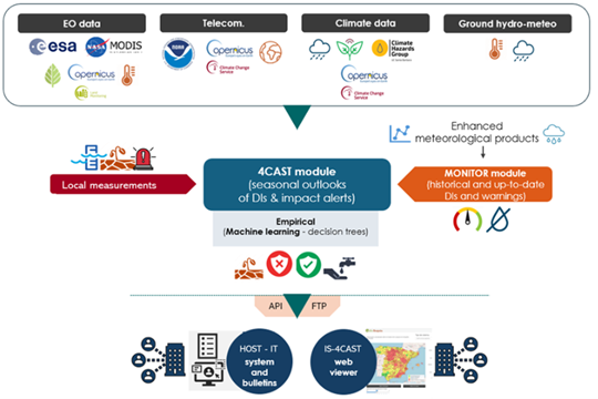
FutureWater speelt een belangrijke rol in MegaWat door het coördineren van het werkpakket dat tot doel heeft simulatie-instrumenten te ontwikkelen en te testen die helpen bij de aanpassing aan megadroogtes en het ondersteunen van het besluitvormingsproces. Twee specifieke doelstellingen worden nagestreefd in dit werkpakket: a) de ontwikkeling van een methodologisch prototype voor het kwantificeren van impacten en het identificeren van kantelpunten voor waterveiligheid in sneeuwafhankelijke stroomafwaartse stroomgebieden, en b) de generatie en integratie van sneeuwdroogte-indicatoren in het Drought Early Warning System van FutureWater, genaamd InfoSequia (zie onderstaande figuur).
Workflow van het InfoSequia Early Warning System ontwikkeld door FutureWater en aangepast voor de detectie van kantelpunten van watertekort in sneeuwafhankelijke stroomgebieden. Meer informatie over InfoSequia.
Dit project heeft financiering ontvangen van het Water4All-programma met cofinanciering van CDTI (Spaanse Dienst voor Wetenschap en Technologie) en het Horizon Europe-kaderprogramma van de EU voor onderzoek en innovatie.