FutureWater supports Fiera Comox in its due diligence process for the acquisition of a vertically integrated tree-fruit operation in North Spain. Particularly, FutureWater addresses an overall assessment of the most important water-related factors of risk that may control the current and medium-term feasibility of the fruit orchard farming system of interest. The application of FutureWater’s approach applies a multicriteria analysis and allows to qualify the levels of risk for each key factor analyzed.

FutureWater’s approach rests on: 1) the collection and analysis of data retrieved from documents, large datasets, and in-situ field inspections and stakeholder interviews, and 2) the scoring of the risks previously identified based on a final expert judgment.

Key sources of information for this risk screening included:

  • Existing documentation, reports, plans, and local legislation that may affect the access to water for irrigation
  • Existing and publicly accessible spatial and GIS data, including satellite imagery and thematic datasets available through national and regional agencies and platforms (Ebro River Basin Authority, National Infrastructure of Geospatial Data, Spanish Information System of Water)
  • Meteorological data (rainfall and temperature) from nearby weather stations
  • Groundwater level from the Spanish National Ministry of Environment.
  • Private data and documents generated by clients and stakeholders through personal and follow-up communications with farmer

Key variables analyzed and evaluated at the district and regional scales, to the extent relevant to the farm, included:

  • Water availability of surface and groundwater resources. For groundwater, a trend analysis of water levels, and first-order assessment of quality constraints and risks is included.
  • Impacts of climate change on water resources availability based on rainfall and temperature trends and projections for the region.
  • Water quality for irrigation purposes.
  • Potential conflicts due to competition for water in agriculture and other sectors of activity.

Legislative and policy-related factors that may affect the overall performance were also analyzed risk-by-risk.

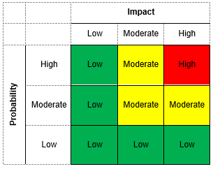
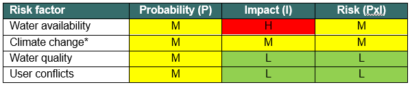
Four factors of risk were analyzed: water availability, climate change, water quality, and water conflict. Each factor of risk was scored according to a risk matrix in which levels of probability of occurrence and impact severity were qualified based on data and expert judgement. For each factor, a risk matrix with three levels of overall risk were adopted: Low Risk (L), Moderate Risk (M), and High Risk (H)

Figure 1. Overall risk levels when probability of occurrence and impact severity are qualified.
Figure 2. Overview of risk assessment by factor.

In this particular project, the approach was implemented in four different settings located in the area.

For smallholder farming systems, there is a huge potential to increase water productivity by improved (irrigated) water management, better access to inputs and agronomical knowledge and improved access to markets. An assessment of the opportunities to boost the water productivity of the various agricultural production systems in Mozambique is a fundamental precondition for informed planning and decision-making processes concerning these issues. Methodologies need to be employed that will result in an overall water productivity increase, by implementing tailored service delivery approaches, modulated into technological packages that can be easily adopted by Mozambican smallholder farmers. This will not only improve the agricultural (water) productivity and food security for the country on a macro level but will also empower and increase the livelihood of Mozambican smallholder farmers on a micro level through climate resilient production methods.

This pilot project aims at identifying, validating and implementing a full set of complementary Technological Packages (TP) in the Zambezi Valley, that can contribute to improve the overall performance of the smallholders’ farming business by increasing their productivity, that will be monitored at different scales (from field to basin). The TPs will cover a combination of improvement on water, irrigation, and agronomical management practices strengthened by improved input and market access. The goal is to design TPs that are tailored to the local context and bring the current family sector a step further in closing the currently existing yield gap. A road map will be developed to scale up the implementation of those TPs that are sustainable on the long run, and extract concrete guidance for monitoring effectiveness of interventions, supporting Dutch aid policy and national agricultural policy. The partnership consisting of Resilience BV, HUB, and FutureWater gives a broad spectrum of expertise and knowledge, giving the basis for an integrated approach in achieving improvements of water productivity.

The main role of FutureWater is monitoring water productivity in target areas using an innovative approach of Flying Sensors, a water productivity simulation model, and field observations. The flying sensors provide regular observations of the target areas, thereby giving insight in the crop conditions and stresses occurring. This information is used both for monitoring the water productivity of the selected fields and determining areas of high or low water productivity. Information on the spatial variation of water productivity can assist with the selection of technical packages to introduce and implement in the field. Flying sensors provide high resolution imagery, which is suitable for distinguishing the different fields and management practices existent in smallholder farming.

In May 2020, FutureWater launched an online portal where all flying sensor imagery from Mozambique, taken as part of the APSAN-Vale project, can be found: futurewater.eu/apsanvaleportal

Project video: Portrait of the activities on water productivity

This project is part of the technical-innovation support provided by FutureWater to ECOPRADERAS, an EIP-AGRI Operational Group led by Ambienta Ing. and co-funded by the EU and the Spanish Ministry of Agriculture. As a general objective, ECOPRADERAS aims to improve the sustainable management of grasslands located at the Alagon Valley (Extremadura, Spain) through: (1) the transfer and implementation of innovative technologies, (2) the identification and strengthening of good cultural practices, and (3) the dissemination of the most relevant information and results among end users.

In the frame of ECOPRADERAS, FutureWater is tasked with the development of an operational monitoring tool able to inform, at the regional scale, on the health status of the grasslands by using satellite data of moderate spatial resolution. The ECOPRADERAS monitor includes the following innovative features:

  • Generation of a categorical index indicative of the health status of grasslands based on the combination of indices of spatial and temporal greenness anomalies.
  • Higher spatial details by using satellite images of moderate spatial resolution (collection of Landsat-8TM of 30 m resolution)
  • Large improvement for collecting and processing large satellite datasets by using the Google Earth Engine cloud-based geoprocessing platform (collection of Landsat-8TM from January 2014 onwards)
  • A user friendly web-mapping interface to visualize outputs

The methodology used by FutureWater uses massive data processing technologies in the cloud (Google Earth Engine) to compute a pixel-based categorical index that result of the combination of a spatial and a temporal anomaly of the greenness index (NDVI). After a local calibration that needs to be adopted, this qualitative index, called the Combined Index of Normalized Anomalies (ICAN) (figure), classifies the status of grasslands in the region of interest into different categories that informs on the health grasslands and how are they being managed. With the ICAN, land managers and local actors can early detect those portions in the landscape in which management practices may pose a risk for the sustainability of the agropastoral system and then would require special attention for improving them.

Logic diagram for computing the Combined Index of Normalized Anomalies (ICAN) in the ECOPRADERAS Monitor.The specific tasks developed by FutureWater included: the definition of a methodological framework for monitor the health of grasslands at the regional scale, the design of a processing and web-mapping platform and its practical implementation in the Alagon Valley (182 km2) from September 2019 to July 2020, and the calibration-validation of the results by comparing outputs with field observations collected in different pilot sites by other project partners.

An evaluation of the results points out to the strength of the methodology. The processing architecture is also easily scalable to other regions and rangeland landscapes. Further improvements have been also envisioned. The ECOPRADERAS Monitor stands as a very powerful tool to guide landscape managers local stakeholders on better decisions.

ECOPRADERAS Monitor at the Alagon Valley (Extremadura, Spain)

The scope of the project work is as follows:

  • Train selected NCBA Clusa PROMAC staff on drone operation, imagery processing software, and crop monitoring;
  • Provide technical assistance to trained NCBA Clusa staff on drone operation, imagery processing, and interpretation of crop monitoring data;
  • Present technical reports on crop development and land productivity (i.e. crop yield) at the end of the rainy and dry season

The trainings and technical assistance for the NCBA Clusa staff are provided in collaboration with project partners HiView (The Netherlands) and ThirdEye Limitada (Central Mozambique). Technical staff of the NCBA Clusa are trained in using the Flying Sensors (drones) in making flights, processing and interpreting the vegetation status camera images. This camera makes use of the Near-Infrared wavelength to detect stressed conditions in the vegetation. Maps of the vegetation status are used in the field (with an app) to determine the causes of the stressed conditions: water shortage, nutrient shortage, pests or diseases, etc. This information provides the NCBA Clusa technical staff and extension workers with relevant spatial information to assist their work in providing tailored information to local farmers.

At the end of the growing season the flying sensor images are compiled to report on the crop development. The imagery in combination with a crop growth simulation model is used to calculate the crop yield and determine the magnitude of impact the conservation agriculture interventions have in contrast with traditional agricultural practices.

In 2011 Colombia, and especially the Magdelena river, was severely hit by large floodings. At the same time drought was experienced in other parts of the river basin. This triggered the Colombian government and water institutions to enforce the attention given to water security and dike safety and opened opportunities for the Dutch government and companies to support the country.

The main project objective is to improve the capacities of Colombia for adaptation of water management to climate change, by:

  • Quantifying the impact of climate change on flood risk and water availability.
  • Identifying critical thresholds in the water system and its management (adaptation tipping points) and sketch future options (pathways) for adaptation.
  • Providing tools/approaches that support water resources (adaptation) planning processes in dealing with uncertainties of climate change and other future developments in small and large river basins.
  • Demonstrating the above for a small (Coello-Combeima) and large (Magdalena) pilot basin and organizing capacity building activities.
  • Exploring opportunities for upscaling within Colombia and other countries in Latin America.

The activities in this pilot project include analysis of historical climate from observations and future climate with downscaled General Circulation Models (GCMs). Historical flood extents and land use is analyzed with space borne radar imagery. A hydrological model is developed to assess climate impacts on water availability and flood frequency and extent. A water allocation model is developed in the Water Evaluation and Planning tool (WEAP) to analyse how current and future water supply relate to sectorial water demands. Adaptation tipping points are determined and effects of different adaptation pathways are evaluated using the models. Results are presented in Colombia during stake holder events.

The projects support the elaboration of the National Adaptation Strategy of Colombia to be elaborated in 2013 and expected to be finished in 2014. As well, between September and November 2014 the National Development Plan will be developed, which defines the plans and investments for a next 4-year period. The National Planning Department of Colombia expects that the presented project goals, and approaches, will enrich these policy strategies and plans.

The consortium for this project is led by Deltares. Other consortium partners besides FutureWater are SarVision and UNESCO-IHE. Local partners are the Instituto de Hidrología, Meteorología y Estudios Ambientales de Colombia (IDEAM), Departamento Nacional de Planeación Colombia (DNP), Corporación Autónoma Regional del Río Grande de la Magdalena (CORMAGDALENA), and Corporación Autónoma Regional del Tolima (CORTOLIMA).

The project is funded by the consortium partners and a grant from the Dutch Government under the “Partners voor Water” scheme.


Significant decisions are to be made to manage and engineer the water systems in Myanmar and to develop large structural and non-structural projects (e.g. hydropower dams, urban water use, industrial development, extension of irrigation capacity, operational quantity and quality management, etc.). Global experience shows that such activities can have irreversible consequences and impose significant costs to economies, cultures and the environment. Early integration of inclusive management strategies can prevent future problems. This is recognized in Myanmar. The Myanmar and Dutch governments have agreed to cooperate on Integrated Water Resources Management (IWRM) through a Memorandum of Understanding (MoU) between the Myanmar Ministry of Transport and Dutch Ministry of Infrastructure and the Environment. To build on the activities that have been performed under this MoU, the project “Leapfrogging Delta Management in Myanmar” was initiated by TU Delft, FutureWater and HKV Consultants, and funded under the Partners for Water program.

Precipitation in Myanmar

Most monitoring and all operations in Myanmar are currently not near-real time. In the Ayeyarwady Delta some real-time data collection stations for water level, rainfall and water salinity measurements have been installed. Yet most data, such as rainfall and water levels, are collected on paper and sent to central offices by post, which can take 2 months. There are also data gaps in the monitoring network, automatic collection of data can diminish the data gaps. Surface water quality is measured only twice a year. Stage-discharge curves once every five years, which is insufficient as the Myanmar rivers are changing rapidly, leading to inaccurate discharge data. Besides monitoring, the big challenge in Myanmar is to convert raw data into useful information for (end) users. Dutch companies have developed tools and assimilation schemes to combine data and convert it into useful and understandable information for different types of clients and users.

In response to the request of the NWRC in Myanmar and the interest of Dutch innovative enterprises, the project’s main aim is to extend the current work in the Bago-Sittaung to the whole Ayeyarwady Delta in accordance with the agreement between the Myanmar and Dutch governments. The aim is to test and demonstrate innovative smart information solutions in the Delta and disseminate the results widely. Coalitions are created around specific information products (e.g. rainfall, erosion, subsidence). In each coalition, partners work on innovative monitoring: to combine remote sensing, ground data collection with modelling techniques. Opportunities and limitations are discussed with Myanmar professionals. In phase two of the project these innovations are tested, both in the field as well in a data platform environment. Innovative technologies and methods will be adjusted according to local circumstances and requirements in consultation with Myanmar. The successful proven innovations are demonstrated during two demonstration weeks in phase three, in which the entrepreneurs explain the products and the results of the testing to the Myanmar stakeholder and (end) users and to the international donors active in this field in Myanmar.

The results of the project will be presented in an online platform based on HKV Dashboard technology, to disseminate the products and services to a local and international audience. Throughout the entire project Dutch and Myanmar experts and young professionals will work together (learning-by-doing) and dissemination and training will be organized. This will facilitate easy adaptation and implementation of the innovations within the Myanmar government.

Based on its experience in operational rainfall monitoring and downscaling to high resolutions using satellite-derived information, FutureWater is developing the first near-real-time spatial rainfall product for Myanmar. The global algorithms will be tailor-made to the Myanmar situation. The first results come available through the online platform over the course of 2017.

SIRRIMED project will address issues related to sustainable use of water in Mediterranean irrigated agricultural systems, with the overall aim of optimizing irrigation water use. The approach proposed in SIRRIMED for reaching this goal will be based in an Integrated Water Irrigation Management (IWIM) where the improved water use efficiency will be considered at farm, irrigation district and watershed scales. These strategies include innovative and more efficient irrigation techniques for improving water productivity and allow savings in water consumption. SIRRIMED will consider the development, test and validation of new deficit irrigation strategies, the sustainable and safe use of poor quality waters and the improvement of precise irrigation scheduling using plant sensors. These new techniques will be integrated with suitable husbandry irrigation practices. At the district scale, efforts should be directed towards an integrated policy of water allocation which accounts for the characteristics and specificity of each farm, requiring the availabity of data bases and efficient management tools (decision support systems) specifically designed to fulfil the objectives of maximizing water use efficiency. At the watershed scale, priority is devoted to the assessment of new models of water governance, and the definition of strategies and policies aimed at promoting a more responsible use of irrigation water. Finally, SIRRIMED will establish a sound dissemination strategy for transfer of knowledge towards the end users, with a real partipatory approach to facilitate an adequate involvement of stakeholders (farmers, association of irrigation users, water authorities and SMEs).

FutureWater has been actively involved in the development of a District Information System (DIS) and a Watershed Information System (WIS) for the Campo de Cartagena case study area.

The proposed DIS will be developed from a GIS-based modelling approach which integrates a generic crop model and a hydraulic model of the transport/distribution system, and will use remote sensing information. The objectives are (i) the development of an operational algorithm to retrieve crop evapotranspiration from remote sensing data, (ii) the development of an information system with friendly user interface for the data base, the crop module and the hydraulic module (WP4 deliverables) and (iii) the analysis and validation of management scenarios from model simulations predicting the respective behaviour of the on-farm and off-farm systems. The overall objective of WP4 is the harmonisation of on-farm and off-farm management by means of a District Information System (DIS) which could be used by stakeholders at purposes of district day-to-day management as well as for planning and strategic decision-making.

The watershed information system (WIS) combines the objectives of acquiring and synthesising the information required for (i) environmental assessment of irrigation activities and (ii) regional planning of water resources, both on catchment scale. In particular, the tool will be designed to supply synthetic and quantitative outputs of the different components of the catchment hydrologic balance, and to diagnose the likely impact of irrigation water use on the quantity and quality of water resources downstream of the irrigation schemes. The development of an information system at the watershed level is a prerequisite for proposing, in the future, strategies of water use and distribution accounting for limited regional water resources and for a limitation of environmental perturbation that can be induced by irrigation activities.

For more information, please visit the SIRRIMED website. Find here a link to the Watershed Information System (WIS) for the Campo de Cartagena.

Rainwater harvesting aims at reaching those people not having access to sufficient and good quality fresh water. They often live in rural areas where other means of water supply are not sufficient or feasible. Within these areas groundwater is not accessible (at technically and/or financially unreachable depths) or potable (due to water quality issues, like fluoride or arsenic contamination) and other surface water (like permanent rivers, lakes and springs) are not available or sufficient to meet basic water needs.

Identifying areas where rainwater harvesting is a feasible solution is one of the aims of the RAIN Foundation. This information on the potential of rainwater harvesting is essential to guide organizations in their implementation efforts, and is at the same time important as a strong lobby tool towards national and international governments.

Besides the current potential, a future oriented approach is required as changes in climate and socio-economic development would alter the need and the potentials for rainwater harvesting. In the years to come, temperatures will rise worldwide, but the weather will also become more extreme. Both prolonged droughts and floods, whether or not combined with sea level rise, are causing a shortage of clean drinking water.

In 2010 FutureWater and Deltares were asked by RAIN Foundation to develop maps indicating the potential for rainwater harvesting (RWH) for Mali, Senegal and Burkina Faso. FutureWater and Deltares used the same approach, but with a slightly different set of input parameters. This report describes the recommended approach to develop maps showing the potential for rainwater harvesting.

The interactive maps can be found here: Rainwater Harvesting Potential in Mali, Senegal & Burkina Faso

Droughts are prolonged periods in which precipitation amounts are relatively low. The term drought is a relative concept whose definition depends on the geographic and physical domain considered. We distinguish among: a) Meteorological droughts, i.e. extended periods with rainfall values below the average, b) Agricultural droughts when the reduction in soil moisture affects crop production, c) Hydrological droughts when the availability of water in rivers, surface reservoirs and aquifers are reduced, and d) Socioeconomic droughts when this period of low rainfall impacts directly on the human productive systems. The increase in the frequency, intensity and severity of droughts are expected to reduce the ability of our societies to cope with those impacts, threatening their water and food security.

Picture1

To ensure the environmental and socioeconomic sustainability of semi-arid regions in the world, under climate and land use changes and more recurrent and larger droughts, we need better tools that are able to: a) anticipate and alert us about their onset, and b) predict, and to supply key information on how to effectively manage and mitigate their potential consequences. Nowadays, an increasing amount of satellite data is becoming available for this purpose. Also, computing facilities are becoming more powerful to process these data and incorporate the latest knowledge on the processes involved and possible impacts. At the same time, a major challenge is to to integrate and interpret these data in synthetically, fast and efficient way, and present it in such a way that it becomes useful for the end-user.

The GEISEQ project aims to develop a Decision Support System for Drought Management integrating a set of tools for: a) the detection, surveillance and monitoring of drought periods, b) the prediction and spatial analysis of their potential impacts, and c) supporting users and decision makers on the best and more efficient management strategies available to mitigate drought consequences. The outcome of the GEISEQ project is a toolbox which makes an efficient use of the data available in the cloud, a set of environmental simulation models, and the human-decision domain through the combination of GIS applications, satellite data acquisition and processing tools, and the adoption of data assimilation techniques.

Flujo_trabajo


logo_meinn_fse_geiseq

Green Water Credits can be seen as an investment mechanism for upstream farmers to practice soil and water management activities that generate benefits for downstream water users, which are currently unrecognized and unrewarded. This initiative is driven by economic, environmental and social benefits. The implementation of GWC has the potential of enhancing overall water management by reducing damaging runoff, increase groundwater recharge, simulate a more reliable flow regime, and reduce harmful sedimentation of reservoirs.

Green Water Credits: the concept.

FutureWater coordinated and carried out the biophysical assessment that quantifies the impact of Green Water Credits practices on the green and blue water and sediment fluxes in the Upper Tana basin. The analysis leads to identification of potential target areas for GWC pilot operation on biophysical grounds. This required a distributed modeling approach (SWAT) accounting for the heterogeneities in the basin in terms of precipitation regime, topography, soil characteristics and land use. The developed tool quantifies the benefits of the management practices on erosion reduction and green and blue water flows in the basin.

Links