The development of the WEAP model for the Thika Chania catchment has come to a stage that it is sufficiently mature for being used over the next year to assess different management scenarios for the Water Allocation Plan. These management options can now be evaluated considering climate change impacts on water resources for different horizons, namely 2030 and 2050.
With this updated model, and the provided trainings, the Water Resources Authority of Kenya is now able to extract Climate Change data for different regions, set-up different WEAP models for different basins, and interpret the results for different time horizons.
The proposed Mombasa Water Fund should secure and improve the quantity and quality of source waters for Mombasa City by channelling investments into source protection and catchment conservation measures of the watersheds. Current spring- and groundwater-based water supply infrastructure is insufficient to meet the city’s growing demands. Focus of the study is therefore on the watershed that serves a new water reservoir (Mwache Dam).
The design study will:
Assess the biophysical, financial, economic and socio-economic benefits of the MWF; and
Identify the potential governance and financing models to establish the MWF
FutureWater performs the biophysical analysis of this study. It aims to link activities in the watershed with positive outcomes for water security. Different combinations of solutions (nature-based primarily) are simulated through an hydrological modelling tool to assess impacts on water quantity and quality, including erosion and sediment yield. The model allows also to assess water demand versus supplies and resulting possible future shortages. Outputs are used in the economic analysis that will cost and valuate different alternative scenarios. The business case study should enable the creation of another successful Water Fund in sub-Saharan Africa promoted by The Nature Conservancy.
In Sub-Saharan Africa, population growth, associated food demand and pressure on natural areas have all increased greatly. Agricultural intensification – more production from the same acreage – remains a key solution to these challenges. One of the cornerstones of intensification is that of a higher and more productive use of inputs, such as fertilizer and water. So far, the average production has remained low and a significant yield gap still exists, mainly among small scale producers (SSPs). The limiting factors are (partly) caused by weather and climatic changes but also by a lack of agronomical knowledge, proper inputs, fertilizers and (climate smart) irrigation techniques. Thanks to the digital revolution Africa is going through, many commercial farmers already have access to a wide range of agricultural services. However, such solutions are not yet accessible to SSPs due to their costs.
A consortium led by FutureWater will collaborate with ETG agronomists and the Empowering Farmers Foundation (EFF) to work together with 60 selected maize, coffee, and tea farmers from around the country to implement Climate Smart Agricultural practices, such as crop rotation to rejuvenate soil nutrients, or mulching to reduce weeds and water erosion. By using drones to monitor the application of these sustainable crop interventions from the selected farms, the project team will also be able to use the data to assess crop productivity improvements, create crop calendars to increase harvest yields, and understand land use changes to protect encroachment into biodiverse areas. Soil samples will also be collected and analyzed to identify soil nutrition deficiencies and design appropriate soil enhancement measures that will be implemented on demo farms. The success of this pilot project will provide learnings on how it can be scaled up to reach more farmers and assess its replicability across different geographic locations.
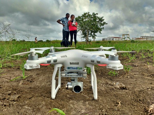
Over the past years FutureWater and HiView managed to develop a low-cost agricultural drone technology which revolutionized the applicability of geo-information services for African farmers: ThirdEye. With the flying sensor service successful local enterprises were established that provide a low-cost drone service to small- and largescale farmers, both in Mozambique and Kenya. ThirdEye’s young agronomist-drone operators support farm decisions based on the flying sensor crop mapping that is viewed on a tablet. Integrating crop nutrition advisory and other improved agronomic practices into the ThirdEye service will bring the (extension) service up to the next level. In this project, we complement the work of flying sensors by ThirdEye with the agronomic service model of Holland Greentech including input distribution, demonstrations and field days, farmer training and coaching and soil testing.
By merging agronomic advisory services making use of low-cost flying sensors, soil testing, climate smart inputs, farmer coaching and an interactive online planning & monitoring portal, the farmer is able to improve his/her:
Planning: What crop to grow in the season based on expected weather, crop prices and market demand;
Cropping: When to sow the seed based on the type of crop and predicted weather
Management: When and where to irrigate, fertilize and apply pesticide. This can help reduce the amount of inputs used in the farm and increase yields, thus helping with profitability.
Harvest: When to harvest the crop based on market prices and predicted weather.
Market linkage: The ability to make informed decisions on where to sell their produce, which may increase their income.
Climate resilience: Option to order climate smart inputs and technologies from different suppliers. These technologies include hybrid seeds, propagation units and greenhouses, (drip) irrigation equipment, soil analysis, biological soil enhancers and biological pest control products.
This project is a collaboration between ETG Kenya, Empowering Farmers Foundation, Eco-Business II Sub-Fund Development Facility, HiView, FutureWater, Holland Greentech and ThirdEye Kenya. For more information visit: https://www.ecobusiness.fund/
This course on hydrology and water allocation modelling is organized for the Kenya Water Resources Authority (WRA) and funded by the Blue Deal program of the Netherlands. The first four-week course block introduces the participants to the main concepts in hydrology, hydrological modelling and data collection, including remote sensing. Exercises are provided on water balances, land use datasets, extraction of rainfall data from remote sensing datasets, among others.
The 5-week second block of the training is on the use of a water resources system model (WEAP) for water allocation. Participants will learn how to develop, run and evaluate a model, including scenario analysis, water balances, assess impact of changing priorities among users, and impacts on water shortage. The learned skills will be used afterwards for establishing a Water Allocation Plan for an important sub-basin of the Upper Tana river, providing water to many livelihoods in the catchment itself, but also to Nairobi city.
Aim of the training
The training will enhance capacity of Egerton educational staff in accessing and using innovative data and tools in the public domain, to analyse crop performance and irrigation management. During the training, university participants will be specifically supported in developing course modules based on the skills gained. To maximize the impact in addressing the need for increased quality of higher education in the agricultural sector, representatives from other institutes, ministries and private sector companies will also be invited. The training will allow the staff to gain advanced skills in working with flying sensors (drones) and satellite-derived data to support agricultural and water-related challenges, such as pests and diseases, water efficiency in agriculture to enhance food security, and drought monitoring. They will acquire insight in and knowledge on analyzing the performance of crops, making the right intervention decisions and giving irrigation advice. For public sector representatives, the training objective is to obtain skills that can be directly and sustainably implemented in their respective organizations.
Overall, the Kenyan society at large will benefit from improved food security provided by well-educated agricultural researchers and professionals. This project forms an important step in the capacity building strategy as it focuses on strengthening the universities and preparing them to provide high quality education to the future generation agronomists and agricultural managers, as well as upgrading the knowledge of current professionals.
The training costs of four stages: an online training course, followed by an in-country training program, symposium and post-training support.
Stage 1: eTraining course
The first stage involved a weekly online training course that will start in January 2021, with a total of six sessions in six weeks. Participants will be consisting of University and TVET faculty members, university students, PhD candidates, researchers, Kenya Agricultural & Livestock Research Organization (KALRO) staff members, Agriculture Extension Staff from the County Government who are already involved in agricultural research and training and other private sector partners. Staff members from the university will be those that are involved in teaching agronomy, horticulture, agriculture engineering and agriculture extension courses and programs, i.e., soil, nutrient and water management, dryland farming, irrigated agriculture and crop protection. Non-university attendants will be technical staff who are close to the decision makers within their organizations. This will enhance the impact of the training by embedding the use of flying sensor and satellite-derived data for agriculture within these organizations and make sure that Kenya will pursue its activities in making use of this kind of information.
This first stage of the training course will be online and will focus on:
Real Water Savings in Agricultural Systems including potential field interventions
The use of WAPOR to access remotely sensed derived data
The course will end with a test and evaluation and graduates will receive a certificate.
Stage 2: Targeted in-country training
After the first stage training a second in-country training will take place with a smaller group, focusing on the use of drones in agriculture. Here a selected group of 12 to 18 members will be trained. Focus will be on staff with lecturing responsibilities, to ensure impact on higher education provision and transfer of the new skills to students.
The in-depth training will consist of:
Operating flying sensors manually and automatic, the processing of the collected data using open source software, interpretation and the subsequent decision making (recommendations to increase productivity) for (smallholder) farmers and actors
Use satellite derived (precipitation) products to run crop growth models to provide advice on when and how much to irrigate in agricultural fields
Participants will work on hands-on exercises related to crop performance analyses, water demands and crop growth modelling. Application of the new skills will be further stimulated by assigning the participants clear, tailor-made goals at the end of the second training session, to be worked on during the distant-support period.
Stage 3: Symposium/knowledge sharing
Right after the second training session, a symposium will be organized for a larger audience including the superiors/managers (who most of the times are the final decision makers) of the training participants and representatives of similar organizations. During this knowledge sharing event, trainees and trainers will actively provide contributions to showcase the newly gained skills and their added value to the respective institutions and the Kenyan agricultural sector in general. By acquainting the responsible decision makers in these organizations with the potential applications of flying sensor and satellite-derived data relevant to them, this event will be crucial in ensuring a sustainable impact of the TMT.
Stage 4: Post-training support
In this period, progress will be actively monitored and the trainers will provide post-training support to the participants. The support will be both remotely (e.g. through Skype) by the Dutch training providers but also in-person by ThirdEye Kenya staff visiting the participants for Q&A sessions and to evaluate the implementation of the skills they obtained.
For the two study catchments, satellite imagery and field observations were combined to perform a land degradation assessment and to identify trends. Secondly, baseline hydrological conditions were assessed using a hydrological simulation model. Future changes in hydrology and hydropower generation were evaluated by running the biophysical model for a Business-as-Usual scenario, accounting for land degradation trends, changes in water use, and climate change.
Subsequently, the impacts of three catchment investment portfolios (low, medium, high) containing different catchment activities were quantified with respect to the BaU scenario. Benefits and costs were analysed for the hydropower developers to evaluate whether it makes sense for them to invest in improved catchment activities. For one of the catchments this is clearly the case (Kiwira, Tanzania).
The analysis shows that the impacts of climate change on revenue from hydropower are in the same order of magnitude as the other negative anthropogenic factors: increased domestic water use demand in the catchment and land degradation due to poor conservation of natural areas and poor agricultural practices.
The framework used for this evaluation has been the IFC Performance Standards 3 (Resource Efficiency and Pollution Prevention) and 6 (Biodiversity Conservation and Sustainable Management of Living Natural Resources), complemented with what is considered good practice.
There is so far no accepted general methodology for assessing the significance of climate risks relative to other risks to water resources projects that the World Bank Group supports and invests in. The Independent Evaluation Group (IEG) in its 2012 report entitled “”Adapting to Climate Change: Assessing the World Bank Group Experience””, found that “climate models have been more useful for setting context than for informing investment and policy choices” and “they often have relatively low value-added for many of the applications described” and that “although hydropower has a long tradition of dealing with climate variability, the Bank Group lacks guidance on appropriate methods for incorporating climate change considerations into project design and appraisal.”
The book “”Confronting Climate Uncertainty in Water Resources Planning and Project Design: The Decision Tree Framework”” by Casey Brown and Patrick Ray was published in 2015. Since then, the Decision Tree Framework (DTF) has been applied to Bank projects facing diverse situations in six pilots covering hydropower, water supply, and irrigation with funding from the Water Partnership Program (WPP). This effort is continuing in two additional pilots with financing from the Korea Green Growth Trust Fund (KGGTF) targeting the resilience component of water security of flood protection and irrigation in the Nzoia River basin in Kenya and the application of the Hydropower Sector Climate Resilience Guidelines (which in turn are based on the DTF) to the Kabeli-A hydroelectric project in Nepal.
Together with partners, FutureWater applies the following bottom-up methodology DTF to the Nzoia irrigation project in Kenya and the Nepal’s Kabeli-A run-of-river hydroelectric project study. FutureWater´s main tasks are assessing risks using crop modeling and water allocation modeling of the Nzoia case study, and hydrological modeling of the high-mountain region in Nepal.
Twiga is the Swahili word for ‘giraffe’, a keen observer of the African landscape. TWIGA aims to provide actionable geo-information on weather, water, and climate in Africa through innovative combinations of new in situ sensors and satellite-based geo-data. With the foreseen new services, TWIGA expects to reach twelve million people within the four years of the project, based on sustainable business models.
Africa needs reliable geo-information to develop its human and natural resources. Sixty percent of all uncultivated arable land lies in Africa. At the same time Africa is extremely vulnerable to climate change. Unfortunately, the in situ observation networks for weather, water, and climate have been declining since the 1970s. As a result, rainfall predictions in Africa for tomorrow have the same accuracy as predictions in Europe, ten days ahead. To realize the tremendous potential of Africa while safeguarding the population against impacts of climate change, Earth observation must be enhanced and actionable geoinformation services must be developed for policy makers, businesses, and citizens. New in situ observations need to be developed that leverage the satellite information provided through GEOSS and Copernicus (Open data/information systems).
TWIGA covers the complete value chain, from sensor observation, to GEOSS data and actionable geoinformation services for the African market. The logic followed throughout is that in situ observation, combined with satellite observations and mathematical models, will result in products consisting of maps and time series of basic variables, such as atmospheric water vapour, soil moisture, or crop stage. These products are either produced within TWIGA, or are already available with the GEOSS and Copernicus information systems. These products of basic variables are then combined and processed to derive actionable geo-information, such as flash flood warnings, sowing dates, or infra-structural maintenance scheduling.
The TWIGA consortium comprises seven research organisations, nine SMEs and two government organisations. In addition it uses a network of 500 ground weather stations in Africa, providing ready-to-use technical infrastructure.
FutureWater’s main role in TWIGA is centered around the use of flying sensors to map crop conditons, flood extent, and energy fluxes, complementing and improving data from in situ sensors and satellites. Furthermore, FutureWater is involved in innovative app development.
Background
A key factor in enabling an increase and efficiency in food production is providing farmers with relevant information. Such information is needed as farmers have limited resources (seed, water, fertilizer, pesticides, human power) and are always in doubt in which location and when they should supply these resources. Interesting is that especially smallholders, with their limited resources, are in need of this kind of information. Spatial information from flying sensors (drones) can be used for this. Flying sensors offer also the opportunity to obtain information outside the visible range and can therefore detect information hidden for the human eye (Third Eye). Nowadays, low-cost sensors in the infra-red spectrum can detect crop stress about two weeks before the human eye can see this.
The ThirdEye project supports farmers in Mozambique and Kenya by setting up a network of flying sensors operators. These operators are equipped with flying sensors and tools to analyse the obtained imagery. Our innovation is a major transformation in farmers’ decision making regarding the application of limited resources such as water, seeds, fertilizer and labor. Instead of relying on common-sense management, farmers are now able to take decisions based on facts, resulting in an increase in water productivity. The flying sensor information helps farmers to see when and where they should apply their limited resources. We are convinced that this innovation is a real game-changing comparable with the introduction of mobile phones that empowered farmers with instantaneous information regarding markets and market prices. With information from flying sensors they can also manage their inputs to maximize yields, and simultaneously reduce unnecessary waste of resources. In summary, the missing information on markets has been solved by the mobile phone introduction, the flying sensors close the missing link to agronomic information on where to do what and when.
Flying sensors
Thanks to our innovation, farmers’ demand for key agricultural information will be satisfied by means of an extension service based on flying sensor (drone) information. The deployment of flying sensors is unique in its ability to provide farmers with real-time, high-resolution, and on-demand information. We provide essential agricultural information:
At an ultra-high spatial resolution (NDVI)
With unprecedented flexibility in location and timing
Based on wavelengths not observable by the human eye
With a country-specific business oriented approach.
To this end, we use low-cost high-resolution flying sensors (drones) in a development context to ensure that farmers will get information at their specific level of understanding, and simultaneously develop a network of service providers in Mozambique and Kenya.
A flying sensor is a combination of a flying platform and camera. Reliable flying sensors are on the market in a wide-range of categories each with its specific characteristics. Based on the consortium’s experiences over the last years low-cost flying sensors have been identified that are excellent equipped for our innovation. Typically, a flying sensor flies at a height of 100 meter and overlapping images are taken about every 5 seconds. This results in individual images covering about 50 x 50 meter and an overlap of 5 images for each point on earth. So, in order to cover 100 ha 500 images are taken during a flight.
The use of Flying Sensor is unique and no comparative techniques exist that provide farmers with real-time high-resolution information. The use of satellites to provide farmers with spatial information has been promoted but has three main limitations: they have fixed overpass times, the spatial resolution is low, and the presence of clouds halters the information. It is unlikely that, within the coming decades, progress in satellites will be real competitors of flying sensors. Another category of comparable techniques to provide farmers with information is the use of ground sensors. Typical examples of these sensors are soil moisture devices, soil sampling and laboratory analysis, crop sampling and laboratory analysis. However, all those sensor techniques have the common limitation that information is only local point representative, while the main question farmers have is regarding to spatial differences. Moreover, these ground sensors are in all cases too expensive to be used by small-scale farmers.
Our flying sensors have cameras which can measure the reflection of near-infrared light, as well as visible red light. These two parameters are combined with a formula, giving the Normalized Difference Vegetation Index (NDVI). This information is delivered at a resolution of 2×2 cm in the infra-red spectrum. Infra-red is not visible to the human eye, but provides information on the status of the crop about two weeks earlier than what can be seen by the red-green-blue spectrum that is visible to the human eye. NDVI is the most important ratio vegetation index and says something about the photosynthesis activity of the vegetation. Moreover, NDVI is an indicator for the amount of leaf mass, and therefore, ultimately biomass. In general, open fields have a NDVI value of around 0.2 and healthy vegetation of around 0.8. NDVI values give an indication of crop stress. This can be caused by a lack of water, lack of fertilizer, pests or abundancy of weeds.
This Flying Sensor is equipped with infrared sensors that detect crop stress about two weeks before the naked eye can observe this.
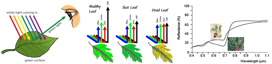
NDVI technology
When light falls on a leaf, reflection occurs. The amount of reflection of green light (0.54 µm) is very high, making plants green to the human eye. Healthy vegetation does not reflect much red light (0.7 µm), since it is absorbed by chlorophyll abundant in leaves. In the near-infrared spectrum (0,8 µm) the amount of reflection increases rapidly to 80% of the incoming light. This increase is caused by the transition of air between cell kernels. This is characteristic for healthy vegetation.
Damaged plant material does not show this increase in reflected near-infrared light. Moreover, the reflection of red light is much higher than in healthy plant material. By measuring the reflection in these spectra, damaged plant material can be distinguished from healthy plant material (Schans et al., 2011).
With our NDVI technology damaged plant material can be distinguished from healthy plant material.
Progress
From 2014 to 2017, FutureWater has been granted support from the Securing Water for Food program, funded by USAID, Sida and the Dutch Government of Foreign Affairs, for piloting the use of flying sensors to support farmers in Mozambique with their decision making in farm and crop management. In Mozambique, we have transferred our technical skills to local ThirdEye operators over the past 3 years. We currently have 6 active local operators providing service to more than 3,500 farmers over more than 1,600 ha. These operators are able to support over 400 small-scale farmers, by collecting information and sharing it with farmers on weekly basis. Based on the information, farmers take decisions on where to do what in terms of irrigation, fertilizer application and pesticides, helping them improve their water productivity. Furthermore, they now have the capacity to deal with technical issues and are very skilled in providing advice to farmers. As a result, the farmer’s water productivity was increased by 55%, meaning less water is used to achieve the same crop yield as without ThirdEye services. ThirdEye has evolved since 2014 from a start-up to becoming the leading company in Mozambique in the field of mapping and monitoring services for farmers based on aerial images, which will continue to expand its activities over the coming years.
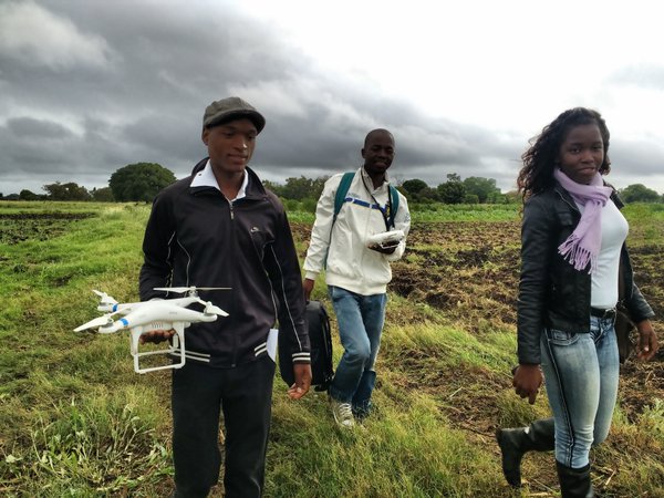
Since last year, the ThirdEye service is also implemented in Kenya as part of the Smart Water for Agriculture program implemented by SNV. Last month the first round of training was given to 5 operators, who will be serving at least 2,000 smallholder farmers the coming months. Training consists of flying sensor use, technical skills, safety and protocols, imagery processing and consultancy. After this, the operators will start working regularly in the regions of Meru and Nakuru. Here they will go the farmer’s fields, conduct flying sensors flights, process the images and give advice on improving their agricultural practices. Next to the service for smallholder farmers, ThirdEye delivers various services to medium and big sized farmers.