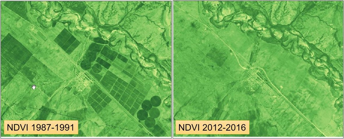
The government of Kazakhstan with financial support of the Asian Development Bank (ADB) is planning to upgrade and rehabilitate its irrigation sector. A detailed Climate Risk and Vulnerability Assessment (CRVA) has been undertaken by a consortium led by FutureWater in 2017. The team collected all available data on the project and had undertaken a rigorous analysis of the risk and vulnerability of climate change on the proposed project. Interactions with the project team, field visits, and extensive analysis using advanced modelling and impact assessment tools (e.g. remote sensing, WEAP) have been undertaken. The work had been focused at two levels: (i) oblast level, and (ii) sub-project level.
A detailed Climate Risk and Vulnerability Assessment (CRVA) report has been developed. The main findings of the CRVA are:
In terms of climate change observations over the last 60 years:
- The average annual temperature in Kazakhstan has been rising by 0.3 ºC/decade. The rate of warming is more pronounced during spring / autumn
- Increase in annual mean temperatures is most pronounced in Aktobe and Kyzlorda oblasts and least in East Kazakhstan.
- The length of dry spells has increased over conterminous Kazakhstan concurrently with observed increasing trends in precipitation intensity.
- In Kazakhstan precipitation tends to slightly decrease of 1 mm per decade in all seasons except winter when precipitation tends to increase by 2 mm per decade.
In terms of climate change projections for the coming decades:
- Mean annual temperatures are projected to increase by 2.5°C by the 2020s, 4.5°C by the 2050s and 7.0°C by the 2080s under RCP 8.5 concentration pathway.
- A significant increase in precipitation of about 24% during the winter by the end of this century. However, during the summer season, a decline of -13% in precipitation is projected.
In terms of impact of climate change:
- Higher crop water requirements of about 8-10% by 2020 and 15% by 2050 compared to the reference (1990).
- Seasonal shift with earlier planting opportunities and therefore irrigation demands earlier in the season.
- Substantial reduction in runoff to streams and rivers as a result of higher evaporation rates and precipitation reductions.
- Higher flooding risks due to projected extremes in daily rainfall, especially in the more mountainous regions.
- Falling groundwater tables as a result of lower recharge.
In terms of adaptation of climate change:
- Design crop water requirements at 10-15% higher compared to the 1990 climate data. Design criteria for canals should also be 10-15% higher.
- Design of storage capacity should be substantially higher to compensate for the projected decrease in base flows and increase in demand. Exact numbers should be Sub-Project and Project level determined.
- Awareness raising to farmers is needed to make them aware that changes in climate will influence water delivery and will gradually lead to a change in cropping patterns and farm water management.