Challenge
Meeting the food and fibre demands of a growing global population is a considerable challenge. To date, irrigated agriculture has been responsible for 40% of the total food and fiber production whilst using only 18% of world’s arable land (Schultz et al., 2009). Irrigation requirements, however, account for nearly 70% of the world’s total freshwater withdrawals (FAO, 2013) and have significantly altered hydrological and environmental conditions in both surface and subsurface water resources (Döll et al., 2009; Kirby et al., 2014; Restrepo and Kettner, 2012; Zeng and Cai, 2014). This has generated criticism and debate about the (un)sustainability of irrigated agriculture. Irrigation managers must often justify the use, efficiency and productivity of water in competition and comparison with other uses and users. The challenge is to enhance water allocation decisions to reduce negative environmental impacts, whilst continuing to satisfy food and fibred demands. Research and investments have been oriented towards applying cost effective technology, precision agriculture, and environmentally friendly techniques to pursue sustainable water use in agricultural development (Baumüller, 2018; Chuchra, 2016; Far and Rezaei-Moghaddam, 2018; King, 2017; Nikouei et al., 2012; Pareeth et al., 2019). Such a trend has been supported by several interlinked goals in the 2030 Agenda for Sustainable Development, in particular Sustainable Development Goal (SDG) 6: Ensure availability and sustainable water management; SDG 2: End hunger, achieve food security, improve nutrition and promote sustainable agriculture and SDG 13: Take action to combat climate change and its impacts. The big challenge is to improve local irrigated agriculture in order to achieve the interlinked SDG goals. The right balance between increasing agricultural production and reducing environmental impacts has to be implemented in order to safely maintain our water resources and satisfy growing food and fibred demands.
The agricultural sector aims to meet growing food demands whilst reducing associated water consumption, which is essential for regions coping with (severe) water scarcity. Both food production and water are integrated in the indicator ‘water productivity’ also commonly referred to as ‘water use efficiency’. This term provides information on the amount of agricultural production achieved with the water consumed through evapotranspiration. Water productivity is used as a performance indicator for various purposes, these include (amongst others): quantifying improvements made through implementing good practices; identifying locations of high water productivity; and determining the potential for improvement through yield gap analysis. The challenge for this rapidly growing field is 1) to develop high-quality spatial data on water productivity and 2) translate this information into practical applications for supporting the agricultural sector in their decision-making.
FutureWater approach
FutureWater aims to provide research and consultancy to help improve water resources management around the world through the application of novel tools and technology. Particularly in irrigation projects, the approach is to integrate hydro-meteorological datasets from ground stations and remote sensing, and simulations from hydrological and crop models to enhance the assessment of water availability and the demand placed on irrigated areas. Additional hydro-meteorological datasets from satellites and flying sensors are also used to support water allocation decisions and deliver timely water resource assessments in large regions, but also at farm level. Advice can therefore be provided on irrigation scheduling, crop suitability, and irrigation area planning based on impact scenarios considering climate variability and climate change. Thanks to the use of state-of-the-art geographical information systems and models, it is possible to obtain spatially distributed information for different levels of advice (e.g. farm level, irrigation district, or basin level). Through these tools FutureWater provides successful irrigation advice in many areas of the world, helping to contribute to achieving the SDG goals. These tools can also be employed for technical due diligence studies, assessing the agronomic and hydrological conditions of a particular site.
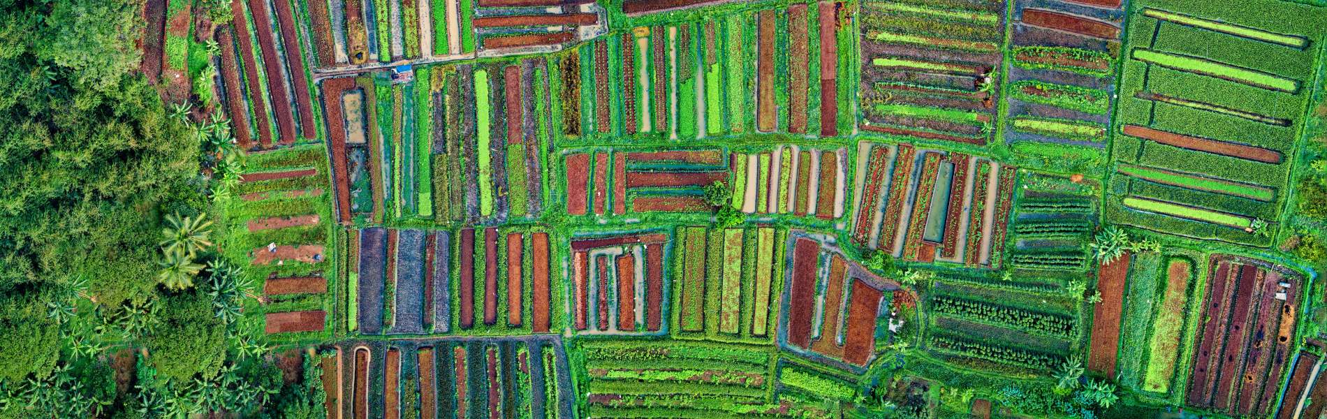
The approach adopted at FutureWater for calculating Water Productivity is through the integration of remote sensing imagery and crop modelling. Remote sensing imagery gives spatial observations of the surface, either obtained through satellite platforms or flying sensors (UAV’s). The type of imagery is selected depending on the required spatial resolution and temporal frequency of observations (time intervals). Subsequently, the imagery is combined with field observations and crop modelling to make a calculation of the crop yield, water balance, and ultimately water productivity. Supplemental to this approach, analyses are performed using open access databases providing spatial information on water productivity, water consumption, or land cover classification. Ultimately, results are presented for practical use such as in field or basin maps indicating the spatial variation, graphs and other illustrations for monitoring trends, or embedded in (smartphone/tablet) apps to aid farmer extension work. Water productivity as a monitoring tool and advisory service can be applied at different spatial scales and for various stakeholders: distribution over the agricultural areas in a river basin, SDG (6.4) monitoring at country scale, irrigation districts, commercial, and smallholder farmers.
Our Solutions
Satellite Remote Sensing
We use satellite data to track various environmental variables such as vegetation, rainfall and land surface temperature. This data helps understand water resources, identify trends and support decision making. Satellite images are combined with models to gain insight into the past, present and future availability of water. We apply this approach in projects focused on drought, ecosystem services and sustainable land management.
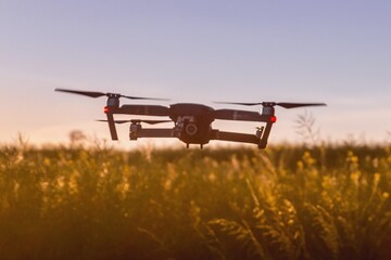
Flying Sensors
We provide farmers in developing countries with valuable information through affordable drones. These drones provide ultra-high resolution images that enable farmers to detect crop stress and make decisions about irrigation, fertilization and pesticides. This service currently operates in Kenya and Mozambique and uses local operators and agronomists.
Crop Growth Models
Crop growth models can be applied in different ways, depending on the underlying equations and the desired goal. We use models such as SWAP, SWAT and AquaCrop to predict crop development and growth. These models are enhanced by using satellite and drone data, resulting in more accurate assessments of crop development and water productivity.
