De watervoorraden van Cambodja staan steeds meer onder druk door klimaatverandering, snelle sociaal-economische ontwikkeling, veranderingen in landgebruik en toenemende concurrentie tussen watergebruikers. In het stroomgebied van de Tonle Sap-rivier hebben seizoensgebonden overstromingen en waterschaarste tijdens het droge seizoen nu al gevolgen voor de landbouw, de bestaansmiddelen, ecosystemen en de infrastructuur. Tegelijkertijd blijft de planning van stroomgebieden in Cambodja versnipperd, waarbij bestaande plannen vaak verschillen wat betreft methoden, tijdshorizonten en koppelingen met de nationale investeringsplanning. Het ‘Cambodia Resilient River Basin Masterplan’ speelt hierop in door een meer geïntegreerde, op bewijs gebaseerde en klimaatbestendige aanpak van stroomgebiedbeheer te ondersteunen.
FutureWater maakt deel uit van een consortium onder leiding van Alluvium en werkt samen met de Aziatische Ontwikkelingsbank en het Cambodjaanse Ministerie van Watervoorraden en Meteorologie aan de opstelling van het ‘Cambodia Resilient River Basin Masterplan’. De eerste fase richt zich op de Tonle Sap-rivierbekkengroep en ontwikkelt rivierbekkenbeheer- en investeringsplannen voor 11 rivierbekkens. Deze plannen brengen de huidige en toekomstige waterbeschikbaarheid, de sectorale watervraag, overstromings- en droogterisico’s, de gevolgen van klimaatverandering, de toestand van ecosystemen en prioritaire investeringsbehoeften in kaart.
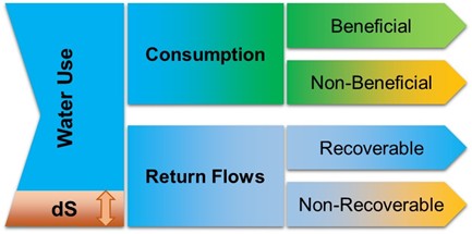
FutureWater leidt belangrijke technische onderdelen op het gebied van hydrologie, modellering van watervoorraden, beoordeling van klimaatrisico’s, teledetectie en waterboekhouding. Voortbouwend op eerdere werkzaamheden in Cambodja, waaronder op WEAP gebaseerde beoordelingen van watervoorraden voor de stroomgebiedgroepen van de Tonle Sap en de Mekongdelta, actualiseert en breidt FutureWater de stroomgebiedmodellen uit, integreert het satellietgegevens en lokale datasets, beoordeelt het de huidige en toekomstige waterbalansen en ondersteunt het scenarioanalyses voor watertoewijzing en investeringsplanning. Deze empirische basis ondersteunt het stellen van prioriteiten voor veerkrachtige waterinfrastructuur, modernisering van de irrigatie, op de natuur gebaseerde oplossingen, herstel van stroomgebieden en maatregelen voor vraagbeheer.
Er wordt sterk de nadruk gelegd op capaciteitsopbouw en praktische toepassing. FutureWater draagt bij aan de ontwikkeling van instrumenten, datasets, modelleringsworkflows en trainingsmateriaal die door Cambodjaanse instellingen, waaronder MOWRAM en het Nationaal Datacentrum voor Waterbeheer, kunnen worden gebruikt ter ondersteuning van toekomstige stroomgebiedplanning en adaptief waterbeheer.