Het BUCRA-project (Building Unity for Climate Resilient Agriculture) richt zich op het versterken van de landbouwresistentie in Qahbunah, een landbouwgemeenschap in de Nijldelta van Egypte. Lokale boeren worden geconfronteerd met uitdagingen zoals waterschaarste, klimaatverandering en versnippering van landbouwgrond, en hebben innovatieve benaderingen nodig om hun levensonderhoud te behouden.
Centraal in BUCRA staan twee geavanceerde tools ontwikkeld door FutureWater: Croptimal en SOSIA, die geavanceerde technologie combineren met lokale kennis om traditionele landbouwpraktijken te transformeren.
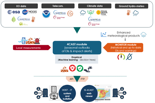
Croptimal is een analyse-instrument voor klimaatgevoeligheid dat klimaatprojecties, geospatiale gegevens en landbouwinzichten benut om de geschiktheid van verschillende gewassen te beoordelen onder huidige en toekomstige klimaatscenario’s. Door gebieden en gewassen te identificeren die het meest bestand zijn tegen klimaatstressfactoren zoals hitte, zoutgehalte en waterschaarste, biedt Croptimal boeren datagestuurde aanbevelingen om hun gewaskeuze en plantstrategieën te optimaliseren. Deze tool levert zeer gedetailleerde kaarten en bruikbare adviezen, waardoor boeren hun praktijken kunnen aanpassen aan de uitdagingen van klimaatverandering en tegelijkertijd hun productiviteit kunnen verhogen.
SOSIA (Satellite-based Open-Source Irrigation Advisory) is een irrigatiebeheertool die is ontworpen om de efficiëntie van watergebruik te verbeteren. De tool maakt gebruik van open-source satellietgegevens, realtime weersinformatie en lokale bodemomstandigheden om nauwkeurige dagelijkse irrigatie-adviezen te geven. Boeren ontvangen via WhatsApp aanbevelingen over hoe lang zij hun gewassen dagelijks moeten irrigeren, waardoor de dienst zowel toegankelijk als kosteneffectief is. Deze innovatieve aanpak vermindert niet alleen het waterverbruik, maar verhoogt ook de gewasopbrengsten en energie-efficiëntie, en speelt zo in op de toenemende druk op watervoorraden in de Nijldelta.
Naast deze tools bevat BUCRA demonstratiepercelen waar klimaatslimme technieken worden getoond, zoals efficiënte irrigatie, bodembeheer en gewasrotatie. Boeren zullen ook deelnemen aan een blended leerprogramma dat veldgerichte training combineert met gebruiksvriendelijke digitale toepassingen om hun technische vaardigheden en kennis te verbeteren.
BUCRA legt sterke nadruk op het empoweren van jongeren en vrouwen in de landbouw, het versterken van marktverbindingen en het bevorderen van duurzame landgebruikspraktijken. Door Nederlandse expertise af te stemmen op lokale behoeften, streeft het project ernaar de productiviteit te verhogen, inkomens te stabiliseren en een duurzame agrarische toekomst op te bouwen in Qahbunah.
De langetermijnvisie is om bredere adoptie van deze tools en praktijken te inspireren, waardoor voedsel- en waterveiligheid in de regio wordt gegarandeerd en de uitdagingen van klimaatverandering effectief worden aangepakt.