A consortium of international development finance institutions led by World bank and including Asian Development Bank (ADB) have signaled their intention to support the financing of the project. The climate risk management approach of the ADB aims to reduce risks resulting from climate change to investment projects by identifying climate change risks to project performance in the early stages of project development and incorporating adaptation measures in the design.

For this project FutureWater undertakes work to analyze climate change risk faced by Rogun HPP and the interaction between climate change, climate-responsive HPP operation, and downstream water resource demand as a 2nd phase following initial due diligence of ADB on available project documentation. The detailed tasks entail:

  • Analyze downscaled CMIP6 General Circulation Model (GCM) to understand projected changes in precipitation and heat trends across climate change scenarios in the Rogun dam catchment area. This includes assessment of indicators for likelihood of heatwave and extreme precipitation events.
  • Undertake an estimate of the Probable Maximum Flood level in the Rogun dam catchment through event-based simulation modelling factoring in changes to projections for extreme precipitation events and changing hydrological processes due to climate change.
  • Estimate the likelihood of annual discharge change based on climate change projections to understand the likelihood of Rogun HPP project economics being negatively affected by declining capacity factor driven by climate change impacts on hydrology.
  • Conduct a first order analysis of present and future glacial lake outburst flood risk based on review of studies from reputable sources.

With the results of this analysis, ADB can update earlier climate risk studies and guide investment decisions.
 

Graphical User Interfaces are available for QGIS but only for SPHY v2.0 at the moment. This project will upgrade these plugins in order to make them compatible with the latest versions of SPHY (v3.0 and v3.1), QGIS and Python available. The updated plugins will also incorporate the additional functionalities to process state of the art new data sources as inputs.

As SPHY is used by FutureWater in several capacity building programs, our aim is to make the access to the data and the model as easy and intuitive as possible. With updated QGIS Plugins, no programming skills will be required to run the model, so a broader audience can use SPHY for their own purposes.

More information can be found at the SPHY website.

Het meest recente onderzoek heeft zich gericht op het identificeren van historische megadroogtes op basis van paleo-gegevens en het begrijpen van hun klimatologische oorzaken, of op de studie van “moderne” gebeurtenissen en hun impact, meestal in laagland- en vlakke regio’s. Hooggebergteregio’s en sneeuwafhankelijke stroomgebieden zijn echter weinig bestudeerd, en er is weinig bekend over de impact van megadroogtes op de toestand en dynamiek van de cryosfeer in bergwatertorens.

Over het algemeen hebben stroomgebieden die afhankelijk zijn van hooggebergtesystemen een intrinsieke capaciteit om het gebrek aan neerslag en overmatige evapotranspiratie te bufferen, afhankelijk van de waterreserves opgeslagen in de cryosfeer (sneeuw, gletsjers en permafrost). Er wordt aangenomen dat deze buffercapaciteit beperkt is tot een kantelpunt wordt bereikt, waarna de impact van watertekorten en temperatuur-extremen kan worden versterkt en het functioneren van ecosystemen en watersystemen in gevaar kan brengen.

MegaWat heeft een dubbele doelstelling: 1) het aanpakken van kennisgebreken over de hydroklimatologische oorzaken van extreme droogtes en hun impact op de waterbalans van de bergwatertorens van Europa, met speciale nadruk op het samenvallen van samengestelde gebeurtenissen en cascade- en multischaleffecten, en 2) het ontwikkelen en voorstellen van nieuwe adaptatiestrategieën om om te gaan met de duur, omvang en ernst van toekomstige megadroogtes en hun potentiële impact op milieu- en sociaaleconomische activa.

Voor de uitvoering richt MegaWat zich op de hooggebergteregio’s van Europa en hun afhankelijke stroomgebieden. MegaWat streeft naar de ontwikkeling van drie producten:

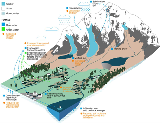
  • Product 1. Een methodologisch kader voor de identificatie en karakterisering van historische megadroogtes tijdens de instrumentele periode, en de beoordeling van de rol van de cryosfeer bij het ondersteunen van de landschapsontwikkeling van stroomafwaartse gebieden, of bij het bufferen van klimaatveranderingseffecten. Product 1 is gebaseerd op een combinatie van klimaatregionalisatie, modellering van de oppervlakte-energiebalans, hydrologische simulatie en analyse van waterevaluatie en -toewijzing op stroomgebiedniveau (zie onderstaande figuur).
  • Product 2. Een hoog-resolutie, open-toegang, geregionaliseerde klimaatdatabase.
  • Product 3. Een lijst van potentiële adaptatiestrategieën die nuttig zijn voor de preventie en mitigatie van droogteeffecten, en voor de versterking van de waterveiligheid en veerkracht van hooggebergteregio’s en afhankelijke stroomgebieden. Deze scenario’s worden overeengekomen met regionale en lokale actoren en belanghebbenden, en hun effectiviteit wordt geëvalueerd onder extreme droogtescenario’s in drie pilotregio’s in Europa. Deze pilotregio’s worden vooraf geselecteerd op basis van criteria van representativiteit, strategisch belang en kwetsbaarheid voor droogtes.


Schematische weergave van een hooggebergtebekken, inclusief de belangrijkste componenten, processen en effecten gerelateerd aan droogtes.

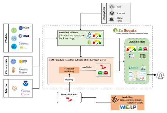
FutureWater speelt een belangrijke rol in MegaWat door het coördineren van het werkpakket dat tot doel heeft simulatie-instrumenten te ontwikkelen en te testen die helpen bij de aanpassing aan megadroogtes en het ondersteunen van het besluitvormingsproces. Twee specifieke doelstellingen worden nagestreefd in dit werkpakket: a) de ontwikkeling van een methodologisch prototype voor het kwantificeren van impacten en het identificeren van kantelpunten voor waterveiligheid in sneeuwafhankelijke stroomafwaartse stroomgebieden, en b) de generatie en integratie van sneeuwdroogte-indicatoren in het Drought Early Warning System van FutureWater, genaamd InfoSequia (zie onderstaande figuur).

Workflow van het InfoSequia Early Warning System ontwikkeld door FutureWater en aangepast voor de detectie van kantelpunten van watertekort in sneeuwafhankelijke stroomgebieden. Meer informatie over InfoSequia.

Een one-pager kan hier worden gedownload.

Erkenningen

Dit project heeft financiering ontvangen van het Water4All-programma met cofinanciering van CDTI (Spaanse Dienst voor Wetenschap en Technologie) en het Horizon Europe-kaderprogramma van de EU voor onderzoek en innovatie.

The aim is to develop a business case for a Watershed Investment Program for Addis Ababa. It includes stakeholder and governance analysis, scientific modeling, return on investment (ROI) analysis, and an implementation plan. Hydrological models are employed to assess the potential of Nature-based Solutions to mitigate the negative trends in the watershed, and improve water supply reliability, water quality, sedimentation and agricultural productivity. The study should raise awareness for all key stakeholders and potential investors. The study is performed under the Nature for Water Facility launched by The Nature Conservancy.

Urban flood management in Laos is typically based on a limited, hard infrastructure approach. With the aim to shift this paradigm towards an integrated approach that enhances climate resilience, the project “Building resilience of urban populations with ecosystem-based solutions in Lao PDR” was approved by the Green Climate Fund Board in November 2019 with a GCF grant of US$10 million. United Nations Environment Programme (UNEP) serves as the Accredited Entity for the project. Activities are executed by the State of Lao PDR through the Ministry of Finance and Ministry of Natural Resources and Environment (MONRE) as well as UNEP. The project is implemented across five years (2020-2025) covering four provincial capitals in the country: Vientiane, Paksan, Savannakhet, and Pakse.

One component of the project involves technical and institutional capacity building to plan, design, implement and maintain integrated urban Ecosystems-based Adaptation (EbA) interventions for the reduction of climate change induced flooding. As a part of Integrated Climate-resilient Flood Management Strategy (ICFMS) development, the project conducts hydrological, hydraulic and climate risk assessments to inform climate change adaptation solutions for risk reduction in Vientiane, Paksan, Savannakhet and Pakse.

A consortium of FutureWater, Mekong Modelling Associates (MMA) and Lao Consulting Group (LCG) was contracted by MONRE to implement the related activities. FutureWater leads and coordinates this assignment and contributes remote sensing analyses with state-of-the-art innovative tools, climate risk assessments, and training activities. To ensure sustainability and effective technology transfer, the modelling and mapping infrastructure and trained staff will be hosted within MONRE and a knowledge hub that is established within the National University of Laos.


Southern Spain is a highly productive agricultural region, but with huge challenges around water scarcity and environmental sustainability. There is a demand in the agricultural sector to work towards water stewardship in Spain. The Alliance for Water Stewardship has developed a Standard which helps retailers and their suppliers to cause change at scale. This approach recognizes that there are common challenges that could be more easily overcome through a collective, place-based approach.

In the Doñana region, berry farms and groundwater usage are causing a conflict with the unique ecosystems in the National Park. A catchment assessment and active stakeholder engagement is needed as a first step in this region to work towards water stewardship. The catchment assessment will provide information on the catchment context, in line with the requirements of the Standard. The purpose of the assessment is to reduce the burden on agricultural sites by providing them with a common set of information which they and others can use to inform responses to their shared water challenges.

Nigeria as a country faces extensive Water Security Challenges (WSCs), from water availability and provisioning to water quality issues. These will become exacerbated by multiple future pressures, including huge increases in population and a changing climate. Oshun and Ogun catchments are located in the South West of Nigeria, in the same area as Lagos. These catchments face multiple challenges including unregulated groundwater extraction and poor sanitation infrastructure which compromise societal access to water.

NbS have the potential to contibute to addressing WSCs by increasing the overall resilience of the hydrological system, helping to increase infiltration to groundwater and buffer water quality issues. Alongside this, NbS can provide a wealth of co-benefits including carbon sequestration and increased biodiversity, complementing more traditional so-called ‘grey’ infrastructure such as pipelines and treatment plants.

Through extensive stakeholder consultation paired with GIS analysis and hydrological modelling, this project will help outline NbS which are best placed to address key WSCs, alongside identifying beneficiaries in the catchments of interest and existing parnerships in the catchment which are capable of delivering projects on-the-ground.

This work lays the foundations for the creation of so-called Watershed Investment Programmes (WIPs) in Osun and Ogun catchments, alongside the identification of further catchments in Nigeria which are disposed towards similar initiatives. WIPs aim to sustain and enhance the provisioning of key water-related ecosystem services by funding the conservation and restoration of lands that protect water quantity and quality. This is achieved through connecting downstream water users (e.g. water utilities, local governments, businesses, and the public) to upstream land managers (e.g. farmers and rural landowners). They unite these parties and others around the goal of enhancing water quality and quantity for societal benefits.

This consultancy project is framed by the AQUIFER project, “Innovative instruments for the integrated management of groundwater in a context of increasing scarcity of water resources” (Interreg-SUDOE V programme) which aims to capitalize, test, disseminate and transfer innovative practices for the preservation, monitoring and integrated management of aquifers.

FutureWater expertise was required for providing a novel and open-source hydrological modelling framework able to quantify spatial patterns of daily root percolation as a direct surrogate of groundwater recharge in the Campo de Cartagena Quaternary Aquifer (CC-QA). This aquifer is located at SE Spain and is one of the most important vectors of water drainage to the Mar Menor lagoon.

This task is addressed through the improvement and local calibration of the SPHY code for the Campo de Cartagena and the simulation of the water balance in the soil root zone from the 1950s until the end 2020. The SPHY-Campo de Cartagena includes a new routine able to compute irrigation inputs at the pixel level based on satellite data. Timeseries of monthly root percolation are taken as good surrogates of potential groundwater recharge and used as the main forcing input to an hydrogeological model of the Quaternary aquifer. The calibration process is performed through a sensititivity-intercomparison analysis in which model-derived outputs (irrigation and streamflow) during the calibration period are cross-checked against actual observations.

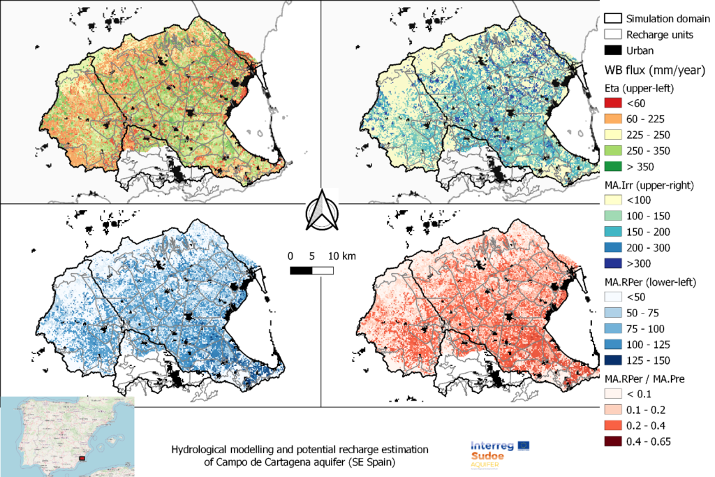
Spatial patterns of root percolation and the relative contribution of irrigation return flows to the total groundwater recharge were quantified (e.g. Figure 1) under historical and current conditions. Simulation results would show the lack of a significant temporal trend in the long-term recharge rates in the aquifer, most likely due to the the strong interannual variability observed in rainfall patterns, but also by the trade-offs resulting from the combination of climate, land use and irrigation-crop management drivers.

Figure 1. Mean Annual values of the main water balance components in Campo de Cartagena (2000-2020). RPer_ratio refers to the fraction between Root Percolation (MA.RPer) and Precipitation (MA.Pre)

De alarmerende afname van bronnen wordt toegeschreven aan de snelle uitbreiding van wegennetwerken, samen met veranderingen in landbedekking en klimaat. Wegenaanleg in deze gebieden stelt bronnen bloot aan verstoringen of verandert hun natuurlijke uitstroom, terwijl rotsafgravingen de locatie van bronopeningen verstoren. Dit probleem is grotendeels onopgemerkt gebleven en vormt een aanzienlijke bedreiging voor de lokale gemeenschappen en hun watervoorraden.

Het overkoepelende doel van het project is om wegen opnieuw te beschouwen als instrumenten voor landschapsverbetering in plaats van als tegenstanders, waarbij wegenaanleg positief bijdraagt aan lokale watervoorraden. Door technieken en hulpmiddelen te integreren (digitale tweelingen en een beslissingsondersteunend instrumentarium), streeft het project ernaar veilige en betrouwbare watervoorziening te waarborgen voor mensen in berggebieden, terwijl de kwaliteit van de weginfrastructuur behouden blijft en de connectiviteit wordt gewaarborgd. De gemeente Dhankuta en het Department of Local Infrastructure (DoLI), dat infrastructuurontwikkelingsactiviteiten in Nepal reguleert, zullen de primaire begunstigden van dit project zijn.

De verwachte resultaten van het RoSPro-project zijn:

  1. Succesvolle implementatie van bescherming van bronnen langs wegen door middel van proefinterventies in de gemeente Dhankuta en het bevorderen van benaderingen zoals “natuurlijke oplossingen” en “Groene Wegen voor Water (GR4W)”.
  2. Generatie van bewijsmateriaal over de impact van de proefinterventie door middel van een kosten-batenanalyse.
  3. Beoordeling van de potentiële impact van het opschalen van bronbescherming langs wegen via de ontwikkeling van een digitale tweeling en een beslissingsondersteunend instrumentarium.
  4. Capaciteitsopbouw voor de gemeente Dhankuta en DoLI met betrekking tot benaderingen, technologieën, impact en opschaling van bronbescherming langs wegen.

RoSPro zal leiden tot verbeterde waterzekerheid voor consumptief en productief gebruik, wat direct tot 500 huishoudens in de regio ten goede zal komen. Na de pilotfase streeft het project ernaar zijn diensten uit te breiden naar bestaande klanten en partnernetwerken in Azië en Afrika. De vraag naar vergelijkbare diensten is hoog in veel hooggebergtegebieden, en RoSPro wil een kader genereren om dit op nationale en regionale schaal op te schalen.

Zo is RoSPro een belangrijke initiatief dat zich richt op het aanpakken van het kritieke probleem van afnemende bronnen in de Himalaya. Door wegenaanleg te transformeren tot een bijdrage aan lokale watervoorraden, zal RoSPro de waterveiligheid en -zekerheid verbeteren, ten goede komen aan zowel de gemeenschappen als het milieu in deze uitdagende bergachtige regio’s.

Tajikistan has initiated the Water Sector Reform Program, aiming to enhance water resource planning and allocation across different river basin zones. However, the development of a comprehensive integrated water resources management plan is hindered by a lack of data on snow and glacier melt. The impact of climate change on the cryosphere, including changes in glacier ice storage, snow dynamics, and evaporation rates, further compounds the issue by affecting high mountain water supply and altering runoff composition and overall water availability.

To address this challenge, the “Integrated Rural Development Project” (IRDP), implemented by GIZ as part of the bilateral development project “Towards Rural Inclusive Growth and Economic Resilience (TRIGGER),” focuses on enhancing the value of agricultural production in Tajikistan. As part of the project, the Water Output (Output 1.5) provides technical support to the Ministry of Energy and Water Resources (MEWR) in the Zarafshon River Basin and at the national level. This support includes technical advisory services, capacity building, training measures, and improving access to irrigation water for small-scale farmers. Local relevant stakeholders foreseen as project beneficiaries are MEWR, Zarafshon River Basin (Zarafshon RBO), Center of Glacier Research (CGR), the Institute of Water Problems (IWP) and the Agency for Hydrometeorology, Tajikistan.

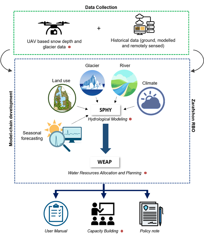
The project has three core components: data collection, modeling, and capacity building, as outlined below. Data collection will include both field monitoring campaigns using UAVs and retrieving historical records which could either be past in-situ observations, remotely sensed or modelled data. This comprehensive dataset will be used to set up, calibrate and validate Spatial Processes in Hydrology (SPHY) and WEAP models. The project will use the model-chain to provide the probabilistic flow forecast (likelihood to be in dry, medium, or wet conditions) using the seasonal meteorological forecast data. The SPHY-WEAP model-chain will then be deployed in the Zarafshon RBO-based servers. The results of the model-chain will be used to develop a comprehensive policy guidance note, proposing strategies and a way forward for developing a robust climate-resilient integrated water resources management plan that will ensure both water availability and accessibility across the river basin. Capacity building is a critical component of the project to ensure its sustainability and upscaling. Therefore, six capacity-building trainings (online and in-country) targeting different technical areas of the project will be organized throughout the project.

By undertaking these efforts, we aim to contribute to the successful implementation of Integrated Water Resources Management in Zarafshon and Tajikistan.