
During this pilot project the applicability of the in-house developed Drought Monitoring and Impact Assessment Toolbox (DMIAT) and HiP2P rainfall downscaling methodology were demonstrated for the Red River Basin in Vietnam. Furthermore the first steps in developing an integrated product for transboundary water management in the Red River Basin were taken. It is envisaged that this will lead to operational implementation and organizational embedding at the relevant Vietnamese government agencies in the coming years.
The Government of Vietnam is challenged to make adequate decisions to adapt to climate change and sea level rise through an integrated approach (agriculture, industry, environment, urbanization and infrastructure). In Vietnam many meteorological stations collect the actual weather conditions. Due to changing weather conditions these historical data are not very reliable for future projection in design of water infrastructure, dikes, etc. There is a need for advanced models in the water sector where space borne imagery and state of the art water models support on predicting future behaviour of the water resources. This is important to support the government of Vietnam in their decision making on how to manage their water resources, design adequate structures (water storage, dams, infrastructure) and safety (dikes, barriers, etc). Planning is even more complex due to the fact that the water resources in Vietnam highly depend on how neighbouring countries manage their water resources. Regional monitoring systems supported by remote sensing can provide important information to the Government on water quality, water quantity, sediment load, water distribution and monitor impacts of the hydropower dams upstream/cross-border. It needs no explanation that these data support Vietnam in regional dialogue on the international rivers and support in its own improved water management.
In November 2011 during a first workshop on ‘Water and Climate Services for transboundary water management and disaster risk management’ it was decided to design a Government to Government (G2G) programme outline with emphasis on capacity development, innovative (hydrologic) models, financial engineering, business development and partnership building regarding RS and GIS technology. Against this backdrop, FutureWater was asked to perform the following activities:
- Capacity building and training of experts of NRSD in Vietnam in remote sensing for rainfall and drought monitoring;
- Identify suitable technologies in remote sensing, rainfall, and drought models for the monitoring and management of transboundary water and disaster risks;
- Demonstrate the use of open software for rainfall and drought monitoring;
- Demonstrate the use of free remote sensing data for Red River Basin transboundary water management.
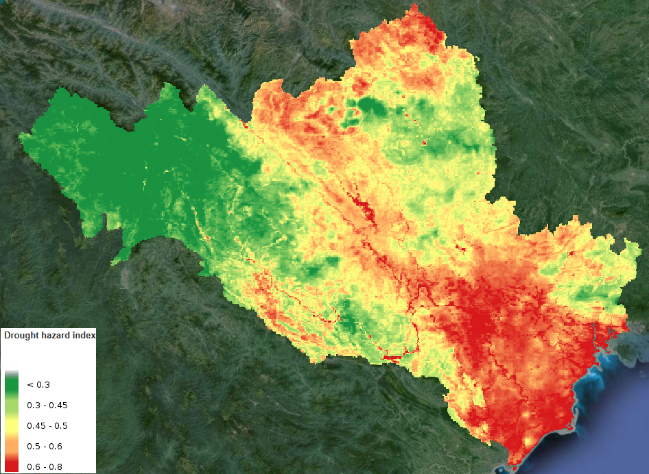
Based on different remote sensing data sources, open geodata and ground-based observations, FutureWater demonstrates the applicability of the in-house developed Drought Monitoring and Impact Assessment Toolbox (DMIAT) and HiP2P rainfall downscaling methodology for the Red River Basin in Vietnam. The Red River Delta is most suitable for piloting a multi-purpose approach in order to cover the aspects of water management and disaster risk management, including transboundary aspects.
During this pilot project, FutureWater and other Dutch partners take the first steps in developing an integrated product for transboundary water management in the Red River Basin. It is envisaged that this will lead to operational implementation and organizational embedding at the relevant Vietnamese government agencies in the coming years.
