This project is part of the technical-innovation support provided by FutureWater to ECOPRADERAS, an EIP-AGRI Operational Group which aims to improve the sustainable management of grasslands located at the Alagon Valley (Extremadura, Spain). Specific tasks included: the definition of a methodological framework for monitor the health of grasslands at the regional scale, the design and implementation of a cloud-based processing and web-mapping platform in the Alagon Valley, and the calibration-validation of the results by comparing outputs with field observations collected in different pilot sites by other project partners. The ECOPRADERAS Monitor has shown as a useful tool to identify hotspots of landscape with good management practices or degradation signals. The methodology and the processing architecture is easily scalable to others rangelands.
This project is part of the technical-innovation support provided by FutureWater to ECOPRADERAS, an EIP-AGRI Operational Group led by Ambienta Ing. and co-funded by the EU and the Spanish Ministry of Agriculture. As a general objective, ECOPRADERAS aims to improve the sustainable management of grasslands located at the Alagon Valley (Extremadura, Spain) through: (1) the transfer and implementation of innovative technologies, (2) the identification and strengthening of good cultural practices, and (3) the dissemination of the most relevant information and results among end users.
In the frame of ECOPRADERAS, FutureWater is tasked with the development of an operational monitoring tool able to inform, at the regional scale, on the health status of the grasslands by using satellite data of moderate spatial resolution. The ECOPRADERAS monitor includes the following innovative features:
- Generation of a categorical index indicative of the health status of grasslands based on the combination of indices of spatial and temporal greenness anomalies.
- Higher spatial details by using satellite images of moderate spatial resolution (collection of Landsat-8TM of 30 m resolution)
- Large improvement for collecting and processing large satellite datasets by using the Google Earth Engine cloud-based geoprocessing platform (collection of Landsat-8TM from January 2014 onwards)
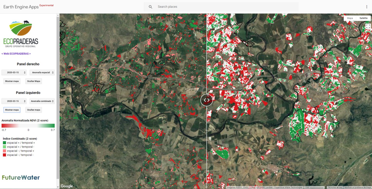
- A user friendly web-mapping interface to visualize outputs
The methodology used by FutureWater uses massive data processing technologies in the cloud (Google Earth Engine) to compute a pixel-based categorical index that result of the combination of a spatial and a temporal anomaly of the greenness index (NDVI). After a local calibration that needs to be adopted, this qualitative index, called the Combined Index of Normalized Anomalies (ICAN) (figure), classifies the status of grasslands in the region of interest into different categories that informs on the health grasslands and how are they being managed. With the ICAN, land managers and local actors can early detect those portions in the landscape in which management practices may pose a risk for the sustainability of the agropastoral system and then would require special attention for improving them.
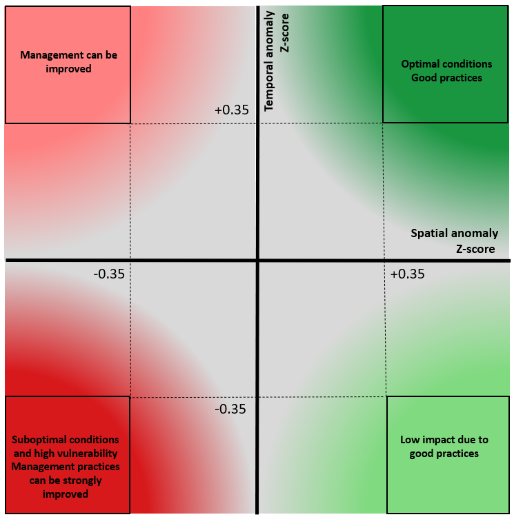
Logic diagram for computing the Combined Index of Normalized Anomalies (ICAN) in the ECOPRADERAS Monitor.The specific tasks developed by FutureWater included: the definition of a methodological framework for monitor the health of grasslands at the regional scale, the design of a processing and web-mapping platform and its practical implementation in the Alagon Valley (182 km2) from September 2019 to July 2020, and the calibration-validation of the results by comparing outputs with field observations collected in different pilot sites by other project partners.
An evaluation of the results points out to the strength of the methodology. The processing architecture is also easily scalable to other regions and rangeland landscapes. Further improvements have been also envisioned. The ECOPRADERAS Monitor stands as a very powerful tool to guide landscape managers local stakeholders on better decisions.
Gerelateerde publicaties
2020 - FutureWater Report 212
 Contreras, S., C. Nolet, G.W.H. Simons, 2020. Monitor Ecopraderas: Seguimiento del estado de las praderas de la Vega del Alagón mediante indicadores de satélite. FutureWater Report 212X
Monitor Ecopraderas: Seguimiento del estado de las praderas de la Vega del Alagón mediante indicadores de satélite
Contreras, S., C. Nolet, G.W.H. Simons