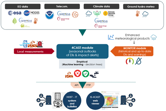
The Food and Agriculture Organization (FAO) launched the Asia-Pacific Water Scarcity Program (WSP) to help countries across the region address the increasing challenges of water scarcity. The program aims to promote sustainable water use and support economic productivity despite growing water constraints.

Mongolia’s inclusion in the WSP presents a valuable opportunity to strengthen its water management capabilities. By applying proven methodologies and resources, the program will enhance the capacity of Mongolia’s Water Resource Ministries and River Basin Organizations (RBOs) to tackle the country’s unique water challenges effectively.

To demonstrate the effectiveness of Water Accounting for improved water management under a changing climate, FutureWater, with FAO’s support, is conducting a Water Accounting assessment for Mongolia’s two key river basins—the Tuul and Orkhon. Using cutting-edge techniques and tools, this initiative will provide critical insights to support sustainable water allocation and long-term resilience.

To this end, FutureWater, in collaboration with unique land use GmbH and the Central Himalayan Rural Action Group, is conducting a training program on Springshed Management in four states, Uttarakhand, Himachal Pradesh, Madhya Pradesh, and Uttar Pradesh India. The program aims to equip the local stakeholders with practical tools and best practices for managing springshed and springs in the region. The key beneficiaries of these trainings are the forest departments of these four states under the Ministry of Environment, Forestry and Climate Change (MoEF&CC). Funded by GIZ India, these trainings will covers key topics, including:

  • Concepts of springs and springshed management protocols and best practices
  • Hydro-geological data collection during a field expedition
  • Springshed mapping
  • Connecting forest ecosystem services to water resources

For the first round of training the consortium will start training with the Uttarakhand Forest Department (UKFD) in Dehradun, India. This initiative aims to strengthen sustainable water management practices and safeguard these critical water sources for future generations.

Graphical User Interfaces are available for QGIS but only for SPHY v2.0 at the moment. This project will upgrade these plugins in order to make them compatible with the latest versions of SPHY (v3.0 and v3.1), QGIS and Python available. The updated plugins will also incorporate the additional functionalities to process state of the art new data sources as inputs.

As SPHY is used by FutureWater in several capacity building programs, our aim is to make the access to the data and the model as easy and intuitive as possible. With updated QGIS Plugins, no programming skills will be required to run the model, so a broader audience can use SPHY for their own purposes.

More information can be found at the SPHY website.

Increasing water scarcity continues to threaten the agricultural sector in Asia. To address this critical issue, FAO and its partners have been developing a comprehensive Asia-Pacific Water Scarcity Programme (WSP) since 2019. The program aims to assess the ongoing issue of water scarcity in the region, evaluate potential management options, and assist partner countries in implementing adaptive management in the agricultural water sector using innovative tools and approaches.

Addressing the issue of water scarcity requires a sound understanding and development of water accounts to ensure evidence-based decision-making for equitable use and allocation of water resources under a changing climate. To achieve this, a comprehensive hands-on training program on water accounting will be developed and implemented across four countries: Indonesia, Lao PDR, Vietnam, and Thailand. In collaboration with the Regional Office for Asia and the Pacific (RAP) of the Food and Agriculture Organization of the United Nations (FAO), FutureWater will design and deliver the water accounting training program. This program aims to not only improve participants’ understanding of water accounting but also enable them to use modern and innovative tools to develop water accounts, with a particular focus on quantifying linkages between field interventions and basin-scale hydrology.

Participants will work with tools such as REWAS and Follow the Water (developed by FutureWater in collaboration with FAO) to conduct water accounting in agricultural systems at different scales. Through the use of these tools, participants will be able to estimate real water savings at system and basin scales and analyze the impact of different irrigation schemes on the overall water availability in the system. Moreover, participants will also learn how to access and extract remotely sensed datasets to assess the status of the water resources in the Nam Ngum pilot basin.

Urban flood management in Laos is typically based on a limited, hard infrastructure approach. With the aim to shift this paradigm towards an integrated approach that enhances climate resilience, the project “Building resilience of urban populations with ecosystem-based solutions in Lao PDR” was approved by the Green Climate Fund Board in November 2019 with a GCF grant of US$10 million. United Nations Environment Programme (UNEP) serves as the Accredited Entity for the project. Activities are executed by the State of Lao PDR through the Ministry of Finance and Ministry of Natural Resources and Environment (MONRE) as well as UNEP. The project is implemented across five years (2020-2025) covering four provincial capitals in the country: Vientiane, Paksan, Savannakhet, and Pakse.

One component of the project involves technical and institutional capacity building to plan, design, implement and maintain integrated urban Ecosystems-based Adaptation (EbA) interventions for the reduction of climate change induced flooding. As a part of Integrated Climate-resilient Flood Management Strategy (ICFMS) development, the project conducts hydrological, hydraulic and climate risk assessments to inform climate change adaptation solutions for risk reduction in Vientiane, Paksan, Savannakhet and Pakse.

A consortium of FutureWater, Mekong Modelling Associates (MMA) and Lao Consulting Group (LCG) was contracted by MONRE to implement the related activities. FutureWater leads and coordinates this assignment and contributes remote sensing analyses with state-of-the-art innovative tools, climate risk assessments, and training activities. To ensure sustainability and effective technology transfer, the modelling and mapping infrastructure and trained staff will be hosted within MONRE and a knowledge hub that is established within the National University of Laos.


Within the project we cooperate with the hydrologists of ARA-Norte to discuss and establish the baseline for a water system analysis in the Monapo Catchment. Following discussion and mapping sessions, FutureWater is developing a Water Allocation Model in WEAP that includes climate change scenarios and mitigation and adaptation measures to asses the water availability of the catchment. Part of the assignment includes continuous training to local professional, to ensure the application of the developed model in the analysis of the system and elaborating specific proposal for implementation in the region.

Groundwater availability is critical to the Umbeluzi Catchment. Currently, there is a need for a simple tool that can asses the availability of resources in the ground.

This especially to asses the permits for groundwater extractions. It is expected that a simplified modelling approach can provide a trend analysis sufficient for the water authorities in Mozambique to perform assessments of the sub-surface water availability. Furthermore, the water availability will be assessed for current and future conditions, under different scenarios of climate change and demand increase.

Within the project, FutureWater will develop a groundwater model in WEAP, using the Strategic Model previously build for the Umbeluzi catchment. To this end a detailed data gathering activity will take place proceed by developing the model. We aim to validate and improve the model with measurements available of groundwater levels in the catchment. The model will be validated with the technical team of ARA-Sul. Ultimately, a dedicated training session for ARA-SUl will ensure that model operation is performed by local experts.

In our ongoing commitment to bolster the efforts of ARA-Sul in Mozambique, FutureWater recently conducted an intensive training course focusing on the application of the Strategic Water Allocation Model within the Umbeluzi Catchment area. This significant initiative entailed the utilization of the renowned Water Evaluation and Planning System (WEAP) model, coupled with a comprehensive update of critical information and underlying assumptions.

The primary objective of this training was to empower the dedicated professionals at ARA-Sul with the knowledge and skills necessary to effectively manage and optimize water resources within the region. The strategic allocation of water resources is of paramount importance, especially in areas like the Umbeluzi Catchment, where water plays a pivotal role in sustaining livelihoods, ecosystems, and economic activities.

One key aspect of this training involved fine-tuning the analysis-scenarios to comprehensively assess potential bottlenecks and challenges within the water allocation system. Identifying these bottlenecks is essential for making informed decisions, developing mitigation strategies, and ensuring the sustainable utilization of water resources.

Our collaborative efforts with ARA-Sul extend beyond the training itself. We are committed to providing ongoing support and guidance to ensure the long-term success of this endeavor. Through regular follow-up activities and consultations, the technical professionals at ARA-Sul are now well-equipped to independently maintain their model and conduct the essential analyses required for informed decision-making.

More information on the training here

Training on WEAP. June 2023.

De alarmerende afname van bronnen wordt toegeschreven aan de snelle uitbreiding van wegennetwerken, samen met veranderingen in landbedekking en klimaat. Wegenaanleg in deze gebieden stelt bronnen bloot aan verstoringen of verandert hun natuurlijke uitstroom, terwijl rotsafgravingen de locatie van bronopeningen verstoren. Dit probleem is grotendeels onopgemerkt gebleven en vormt een aanzienlijke bedreiging voor de lokale gemeenschappen en hun watervoorraden.

Het overkoepelende doel van het project is om wegen opnieuw te beschouwen als instrumenten voor landschapsverbetering in plaats van als tegenstanders, waarbij wegenaanleg positief bijdraagt aan lokale watervoorraden. Door technieken en hulpmiddelen te integreren (digitale tweelingen en een beslissingsondersteunend instrumentarium), streeft het project ernaar veilige en betrouwbare watervoorziening te waarborgen voor mensen in berggebieden, terwijl de kwaliteit van de weginfrastructuur behouden blijft en de connectiviteit wordt gewaarborgd. De gemeente Dhankuta en het Department of Local Infrastructure (DoLI), dat infrastructuurontwikkelingsactiviteiten in Nepal reguleert, zullen de primaire begunstigden van dit project zijn.

De verwachte resultaten van het RoSPro-project zijn:

  1. Succesvolle implementatie van bescherming van bronnen langs wegen door middel van proefinterventies in de gemeente Dhankuta en het bevorderen van benaderingen zoals “natuurlijke oplossingen” en “Groene Wegen voor Water (GR4W)”.
  2. Generatie van bewijsmateriaal over de impact van de proefinterventie door middel van een kosten-batenanalyse.
  3. Beoordeling van de potentiële impact van het opschalen van bronbescherming langs wegen via de ontwikkeling van een digitale tweeling en een beslissingsondersteunend instrumentarium.
  4. Capaciteitsopbouw voor de gemeente Dhankuta en DoLI met betrekking tot benaderingen, technologieën, impact en opschaling van bronbescherming langs wegen.

RoSPro zal leiden tot verbeterde waterzekerheid voor consumptief en productief gebruik, wat direct tot 500 huishoudens in de regio ten goede zal komen. Na de pilotfase streeft het project ernaar zijn diensten uit te breiden naar bestaande klanten en partnernetwerken in Azië en Afrika. De vraag naar vergelijkbare diensten is hoog in veel hooggebergtegebieden, en RoSPro wil een kader genereren om dit op nationale en regionale schaal op te schalen.

Zo is RoSPro een belangrijke initiatief dat zich richt op het aanpakken van het kritieke probleem van afnemende bronnen in de Himalaya. Door wegenaanleg te transformeren tot een bijdrage aan lokale watervoorraden, zal RoSPro de waterveiligheid en -zekerheid verbeteren, ten goede komen aan zowel de gemeenschappen als het milieu in deze uitdagende bergachtige regio’s.

Tajikistan has initiated the Water Sector Reform Program, aiming to enhance water resource planning and allocation across different river basin zones. However, the development of a comprehensive integrated water resources management plan is hindered by a lack of data on snow and glacier melt. The impact of climate change on the cryosphere, including changes in glacier ice storage, snow dynamics, and evaporation rates, further compounds the issue by affecting high mountain water supply and altering runoff composition and overall water availability.

To address this challenge, the “Integrated Rural Development Project” (IRDP), implemented by GIZ as part of the bilateral development project “Towards Rural Inclusive Growth and Economic Resilience (TRIGGER),” focuses on enhancing the value of agricultural production in Tajikistan. As part of the project, the Water Output (Output 1.5) provides technical support to the Ministry of Energy and Water Resources (MEWR) in the Zarafshon River Basin and at the national level. This support includes technical advisory services, capacity building, training measures, and improving access to irrigation water for small-scale farmers. Local relevant stakeholders foreseen as project beneficiaries are MEWR, Zarafshon River Basin (Zarafshon RBO), Center of Glacier Research (CGR), the Institute of Water Problems (IWP) and the Agency for Hydrometeorology, Tajikistan.

The project has three core components: data collection, modeling, and capacity building, as outlined below. Data collection will include both field monitoring campaigns using UAVs and retrieving historical records which could either be past in-situ observations, remotely sensed or modelled data. This comprehensive dataset will be used to set up, calibrate and validate Spatial Processes in Hydrology (SPHY) and WEAP models. The project will use the model-chain to provide the probabilistic flow forecast (likelihood to be in dry, medium, or wet conditions) using the seasonal meteorological forecast data. The SPHY-WEAP model-chain will then be deployed in the Zarafshon RBO-based servers. The results of the model-chain will be used to develop a comprehensive policy guidance note, proposing strategies and a way forward for developing a robust climate-resilient integrated water resources management plan that will ensure both water availability and accessibility across the river basin. Capacity building is a critical component of the project to ensure its sustainability and upscaling. Therefore, six capacity-building trainings (online and in-country) targeting different technical areas of the project will be organized throughout the project.

By undertaking these efforts, we aim to contribute to the successful implementation of Integrated Water Resources Management in Zarafshon and Tajikistan.