To ensure effective implementation, FutureWater will maintain continuous engagement with ARA-Sul, providing technical support and collecting feedback through online sessions. This collaboration will help address challenges in system integration, troubleshoot issues, and refine functionalities. A significant component of this phase is the development of a comprehensive user manual and training materials, including PowerPoint slide decks, to guide ARA-Sul staff in effectively utilizing the tool for water licensing assessments. By embedding the tool within ARA-Sul’s operations, FutureWater aims to enhance decision-making capabilities and streamline the management of water resources in the region.
Het Interregionale Technische Platform voor Waterschaarste (iRTP-WS), geleid door de Voedsel- en Landbouworganisatie (FAO) van de Verenigde Naties, heeft als doel om de kloof tussen praktijk en innovatie te overbruggen om transformatieve veranderingen in water-, land- en landbouwbeheer te stimuleren, vooral in het licht van klimaatverandering. De focus ligt op het verbeteren van de paraatheid van systemen voor water-, voedsel- en klimaatuitdagingen door middel van beter bestuur, capaciteitsopbouw en e-learning.
Voor 2024-2025 richt het werkplan zich op “Geïntegreerde Wateroplossingen: Navigeren door Klimaatverandering en Water-Energie-Voedsel-Ecosysteem (WEFE) Nexus Dynamiek.” Het FAO Regionale Kantoor voor Azië en de Stille Oceaan leidt Strategische Prioriteit 1: Nexus Denken, waarbij cross-sectorale en inclusieve besluitvorming wordt bevorderd om hulpbronnen optimaal te benutten en duurzame WEFE-gebaseerde oplossingen te implementeren.
Om besluitvorming op basis van de nexus-benadering te ondersteunen, ontwikkelt de FAO, in samenwerking met FutureWater, een tool die gebruik maakt van Water Accounting-gegevens om toegankelijke inzichten in WEFE-dynamiek te bieden. Deze tool zal WEAP en de bijbehorende API integreren in een Excel-omgeving, waardoor scenarioanalyses voor zowel projecties als interventies worden gestroomlijnd. Door de krachten van beide platforms te combineren, biedt het een intuïtieve, gestandaardiseerde en collaboratieve benadering van Water Accounting, wat bijdraagt aan een meer geharmoniseerd besluitvormingskader.
A consortium of international development finance institutions led by World bank and including Asian Development Bank (ADB) have signaled their intention to support the financing of the Project. ADB is committed under Strategy 2030 operating priority 3 to support its Developing Member Countries to ensure a comprehensive approach to build climate and disaster resilience. The climate risk management approach of the ADB aims to reduce risks resulting from climate change to investment projects by identifying climate change risks to project performance in the early stages of project development, and which will support decision-making to incorporate the most appropriate adaptation measures in the design.
An initial climate risk assessment has been completed for the Rogun HPP project including assessments of natural hazards, hydrology, sedimentation, and the impact of climate change projections on project performance, however downstream resource implications have not been assessed. In this project FutureWater addresses wider system-level adaptation needs across the Amu Darya basin due to increased water use demand during the Rogun HPP reservoir filling period, climate-driven change to water supply and demand, and identification of potential supply-demand gaps. A combination of hydrological and water allocation modeling will form an evidence-base to inform recommended adaptive measures for the design and operation of Rogun HPP and for wider water-use sectors where required.
FutureWater undertakes analysis to understand projected climate change driven changes in water supply in Rogun HPP upstream areas, and water demands in downstream areas and the wider Amu Darya basin, with a focus on identifying the potential for a supply-demand gap throughout the Rogun HPP reservoir filling period to 2040. Where a risk of a supply-demand gap is identified FutureWater provides recommended measures that can increase water efficiency in the competing demand use sectors with the overall aim of meeting demand across the different scenarios and in compliance with cross-boundary resource sharing agreements.
Specifically, FutureWater addresses following topics:
- Model projected water supply and demand in the Amu Darya river basin by utilizing a WEAP model developed for water supply, demand and allocation analysis, and accounting for climate change, Rogun HPP reservoir filling schedule, changing hydrology patterns and changes to downstream water demand from irrigation and other relevant end-use demands, where relevant.
- Analyze the potential for water resource supply-demand gap to 2040 for a range of climate scenarios that capture potential future pathways aligned to government plans and policies and climate change, where relevant.
- Recommend required water efficiency measures, where a risk of a supply-demand gap is identified under the the limits set by the cross-border water resource sharing agreement, so as to mitgate the risk with high-level cost estimate where capital investment is required.
The Food and Agriculture Organization (FAO) launched the Asia-Pacific Water Scarcity Program (WSP) to help countries across the region address the increasing challenges of water scarcity. The program aims to promote sustainable water use and support economic productivity despite growing water constraints.
Mongolia’s inclusion in the WSP presents a valuable opportunity to strengthen its water management capabilities. By applying proven methodologies and resources, the program will enhance the capacity of Mongolia’s Water Resource Ministries and River Basin Organizations (RBOs) to tackle the country’s unique water challenges effectively.
To demonstrate the effectiveness of Water Accounting for improved water management under a changing climate, FutureWater, with FAO’s support, is conducting a Water Accounting assessment for Mongolia’s two key river basins—the Tuul and Orkhon. Using cutting-edge techniques and tools, this initiative will provide critical insights to support sustainable water allocation and long-term resilience.
The GEF / UNDP / ASEAN Project on Reducing Pollution and Preserving Environmental Flows in the East Asian Seas through the Implementation of Integrated River Basin Management (IRBM) in the ASEAN Countries is a 5-year project (2023-2027) with the goal of establishing functional IRBM mechanisms in seven priority river basins / sub-basins / watersheds in six ASEAN Member States, to reduce pollution, sustain freshwater environmental flows and adapt to climate change vulnerabilities. The Project is designed to improve governance and management arrangements in IRBM and accelerate the required changes in the six AMS in support of national priorities, objectives and commitments to global sustainable development targets using the Source to Sea (S2S) framework. The PEMSEA Resource Facility (PRF), which serves as the Project Implementing Partner, hosts the Regional Project Management Unit (RPMU). It works in collaboration with National and Local Government Partners and River Basin Organizations.
Component 1 of the Project focuses on the conduct of a baseline assessment of the S2S management continuum with a targeted outcome of improving understanding of governance, socioeconomic, ecological conditions, gaps and needs of priority river basins / sub-basins and coastal areas. This will be achieved through the establishment of the State of River Basin (SORB) reporting system to consolidate information coming from administrative, social, economic and environmental sectors. As an input to the SORB baseline reporting, it is required to complete a comprehensive assessment of competing uses and users of water as a consequence of existing and future water uses and their implications on the water / energy / food / ecosystem (WEFE) security nexus in the priority river basins.
FutureWater is providing this assessment of the WEFE security nexus through review of existing knowledge and literature, stakeholder consultations, as well as tailoring and applying its REWEFe toolkit for nexus analysis to seven river basins in six countries of Southeast Asia: Cambodia, Indonesia, Lao PDR, Malaysia, Philippines and Viet Nam.
The UNDP is implementing the project “Conservation and sustainable management of lakes, wetlands, and riparian corridors as pillars of a resilient and land degradation-neutral Aral basin landscape supporting sustainable livelihoods” to enhance the resilience of the ecosystems and livelihoods in Lower Amudarya and Aral Sea Basin (LADAB) through land degradation neutrality (LDN) compatible integrated land-water management.
This assignment contributes to water allocation analysis and the development of water supply scenarios for irrigated agriculture and biodiversity conservation reports. The services consist in:
- Consulting with project experts, government agencies, local communities, and other relevant stakeholders
- Develop a hydro-economic water allocation model for the lower Amu Darya basin using WEAP
- Explore different scenarios for irrigated agriculture and biodiversity conservation, considering climate change, to strike a balance between sustainable agricultural practices and conservation of biodiversity and ecosystems and (iv) build capacity and support project experts and relevant stakeholders on water allocation analysis and modelling.
Het meest recente onderzoek heeft zich gericht op het identificeren van historische megadroogtes op basis van paleo-gegevens en het begrijpen van hun klimatologische oorzaken, of op de studie van “moderne” gebeurtenissen en hun impact, meestal in laagland- en vlakke regio’s. Hooggebergteregio’s en sneeuwafhankelijke stroomgebieden zijn echter weinig bestudeerd, en er is weinig bekend over de impact van megadroogtes op de toestand en dynamiek van de cryosfeer in bergwatertorens.
Over het algemeen hebben stroomgebieden die afhankelijk zijn van hooggebergtesystemen een intrinsieke capaciteit om het gebrek aan neerslag en overmatige evapotranspiratie te bufferen, afhankelijk van de waterreserves opgeslagen in de cryosfeer (sneeuw, gletsjers en permafrost). Er wordt aangenomen dat deze buffercapaciteit beperkt is tot een kantelpunt wordt bereikt, waarna de impact van watertekorten en temperatuur-extremen kan worden versterkt en het functioneren van ecosystemen en watersystemen in gevaar kan brengen.
MegaWat heeft een dubbele doelstelling: 1) het aanpakken van kennisgebreken over de hydroklimatologische oorzaken van extreme droogtes en hun impact op de waterbalans van de bergwatertorens van Europa, met speciale nadruk op het samenvallen van samengestelde gebeurtenissen en cascade- en multischaleffecten, en 2) het ontwikkelen en voorstellen van nieuwe adaptatiestrategieën om om te gaan met de duur, omvang en ernst van toekomstige megadroogtes en hun potentiële impact op milieu- en sociaaleconomische activa.
Voor de uitvoering richt MegaWat zich op de hooggebergteregio’s van Europa en hun afhankelijke stroomgebieden. MegaWat streeft naar de ontwikkeling van drie producten:
- Product 1. Een methodologisch kader voor de identificatie en karakterisering van historische megadroogtes tijdens de instrumentele periode, en de beoordeling van de rol van de cryosfeer bij het ondersteunen van de landschapsontwikkeling van stroomafwaartse gebieden, of bij het bufferen van klimaatveranderingseffecten. Product 1 is gebaseerd op een combinatie van klimaatregionalisatie, modellering van de oppervlakte-energiebalans, hydrologische simulatie en analyse van waterevaluatie en -toewijzing op stroomgebiedniveau (zie onderstaande figuur).
- Product 2. Een hoog-resolutie, open-toegang, geregionaliseerde klimaatdatabase.
- Product 3. Een lijst van potentiële adaptatiestrategieën die nuttig zijn voor de preventie en mitigatie van droogteeffecten, en voor de versterking van de waterveiligheid en veerkracht van hooggebergteregio’s en afhankelijke stroomgebieden. Deze scenario’s worden overeengekomen met regionale en lokale actoren en belanghebbenden, en hun effectiviteit wordt geëvalueerd onder extreme droogtescenario’s in drie pilotregio’s in Europa. Deze pilotregio’s worden vooraf geselecteerd op basis van criteria van representativiteit, strategisch belang en kwetsbaarheid voor droogtes.

FutureWater speelt een belangrijke rol in MegaWat door het coördineren van het werkpakket dat tot doel heeft simulatie-instrumenten te ontwikkelen en te testen die helpen bij de aanpassing aan megadroogtes en het ondersteunen van het besluitvormingsproces. Twee specifieke doelstellingen worden nagestreefd in dit werkpakket: a) de ontwikkeling van een methodologisch prototype voor het kwantificeren van impacten en het identificeren van kantelpunten voor waterveiligheid in sneeuwafhankelijke stroomafwaartse stroomgebieden, en b) de generatie en integratie van sneeuwdroogte-indicatoren in het Drought Early Warning System van FutureWater, genaamd InfoSequia (zie onderstaande figuur).

Een one-pager kan hier worden gedownload.
Erkenningen
Dit project heeft financiering ontvangen van het Water4All-programma met cofinanciering van CDTI (Spaanse Dienst voor Wetenschap en Technologie) en het Horizon Europe-kaderprogramma van de EU voor onderzoek en innovatie.
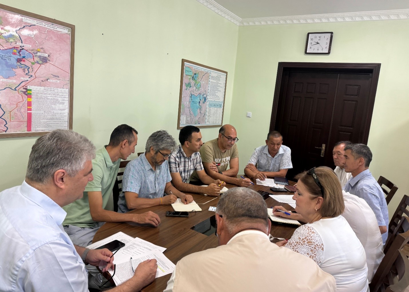
The WEAP model simulates water availability, supply, and demand on a small scale for over 40 irrigation, domestic, and industrial sites, running on a daily timestep to include detailed reservoir operations and water use abstractions. The updated WEAP model was co-designed together with ARA-Sul, the regional water authorities of southern Mozambique. Monthly meetings were held to support information sharing and co-ownership throughout the project.
The model will aid ARA-Sul in water accounting and the licensing of water users served by the Pequenos Libombos Reservoir. The Pequenos Libombos Reservoir, with a storage capacity of 350 MCM, is the main water supplier to the Maputo Metropolitan Area inhabited by over 3 million people. In June 2024 sessions were held in The Netherlands were ARA-Sul was trained in the usage of the model.
The cover picture was taken by David Mucambe (ARA-Sul).
The aim is to develop a business case for a Watershed Investment Program for Addis Ababa. It includes stakeholder and governance analysis, scientific modeling, return on investment (ROI) analysis, and an implementation plan. Hydrological models are employed to assess the potential of Nature-based Solutions to mitigate the negative trends in the watershed, and improve water supply reliability, water quality, sedimentation and agricultural productivity. The study should raise awareness for all key stakeholders and potential investors. The study is performed under the Nature for Water Facility launched by The Nature Conservancy.
Urban flood management in Laos is typically based on a limited, hard infrastructure approach. With the aim to shift this paradigm towards an integrated approach that enhances climate resilience, the project “Building resilience of urban populations with ecosystem-based solutions in Lao PDR” was approved by the Green Climate Fund Board in November 2019 with a GCF grant of US$10 million. United Nations Environment Programme (UNEP) serves as the Accredited Entity for the project. Activities are executed by the State of Lao PDR through the Ministry of Finance and Ministry of Natural Resources and Environment (MONRE) as well as UNEP. The project is implemented across five years (2020-2025) covering four provincial capitals in the country: Vientiane, Paksan, Savannakhet, and Pakse.
One component of the project involves technical and institutional capacity building to plan, design, implement and maintain integrated urban Ecosystems-based Adaptation (EbA) interventions for the reduction of climate change induced flooding. As a part of Integrated Climate-resilient Flood Management Strategy (ICFMS) development, the project conducts hydrological, hydraulic and climate risk assessments to inform climate change adaptation solutions for risk reduction in Vientiane, Paksan, Savannakhet and Pakse.
A consortium of FutureWater, Mekong Modelling Associates (MMA) and Lao Consulting Group (LCG) was contracted by MONRE to implement the related activities. FutureWater leads and coordinates this assignment and contributes remote sensing analyses with state-of-the-art innovative tools, climate risk assessments, and training activities. To ensure sustainability and effective technology transfer, the modelling and mapping infrastructure and trained staff will be hosted within MONRE and a knowledge hub that is established within the National University of Laos.
