Eswatini’s development is at risk by natural drought hazards. Persistent drought is exacerbating the country’s existing challenges of food security and the ability to attain sustainable development. Therefore, FutureWater, Hydrologic, and Emanti Management joined forces to bring together technologies and complementary expertise to implement the GLOW service which includes: short-term and seasonal forecasts of water availability and demand, an alerting service when forecasted water demand is higher than water availability, and water distribution advisories to reduce impact and maximise water security for all water users.

The GLOW service will be piloted in the Maputo River and Mbuluzi River Basins where three-quarters of the population of Eswatini lives, which includes the Hawane dam that supplies water to Mbabane (Capital City of Eswatini) and which is the major water supply source for Maputo, a Delta city (1 million inhabitants) which suffers from water shortages. The main beneficiaries of this project are the Joint River Basin Authority (JBRAS-PB) and the 5 River Basin authorities, AraSul (Mozambique) and the Department of Water and Sanitation (South Africa).

The innovation of GLOW is bringing together proven and award-winning technologies of advanced earth observation, open data, high-performance computing, data-driven modelling, data science, machine learning, operations research, and stakeholder interaction. These technologies require minimum ground truth information, which makes them very scalable and applicable in poorly monitored environments throughout the world. The coherent combination of the technologies into one decision support service ensures the optimum division of water, basically distributing every drop of water to meet the demands of all interests present in large river catchments.

Our climate is changing and cities are facing the consequences. Accessibly tailored climate information is an essential requirement for effective adaptation in cities. Over the years we have learned that for cities to act, it is important to visualize climate information in such a way that it ‘connects’ with priorities of the city. Adaptation should not be a ‘top-down’ activity. Adaptation needs to be ‘mainstreamed’ into various activities that the municipality undertakes. This means climate change needs to be communicated to a wide range of people from different departments. Key to our approach is that we will build the story of climate change adaptation together with the municipality. Our approach is about co-producing a Climate Story Map together with the municipality of eThekwini. Together we bridge the gap between climate science and city level action, going the last mile by translating climate impact information to policy relevant and usable science and embedding that information with the relevant stakeholders.

Key elements in the CAS/FutureWater approach:

  • Strong stakeholder interactions, co-creation processes with ample attention for interactive design supported by visualizations;
  • User-centered and easy-to-understand visualization tools to present the results;
  • Products built on platforms that are proven, stable, reliable and easily transferable;
  • Combination of bottom-up and top-down approaches;
  • Integrated approach balancing natural sciences and social, economic and environmental assessments;
  • Methods based on the latest developments in climate and adaptation science.

At least two types of adaptation approaches can be identified: top-down and bottom-up, both having advantages and drawbacks. A typical top-down approach uses global development scenarios, where different societal and technological developments are described with associated greenhouse gas emissions and climate models to identify climate impacts at various scales and define adaptation needs. This provides insight into a range of future changes but often produces results less relevant for municipal contexts. Bottom-up approaches focus on understanding root causes of local vulnerability to climate change and use participatory processes to address these in adaptation strategies. This can give less importance to physical factors but provides legitimacy through the involvement of people on the ground. These approaches are also less reliant on climate models —which can have limited value at the municipal scale— and take current local vulnerabilities into account. Most current approaches are top-down and focused on large-scale technological interventions, dominated by natural sciences, and are monodisciplinary or sectoral. This is often in conflict with municipal practice where local adaptations focus on integrating social, environmental, and economic dimensions. While both approaches play important roles in planned climate adaptation, merging best practices can be beneficial. This is what we aim to do.

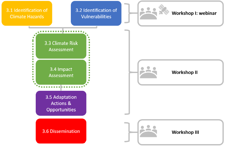
The figure below summarizes our approach, consisting of six steps.

Twiga’ is the Swahili word for ‘giraffe’, a keen observer of the African landscape. TWIGA aims to provide actionable geo-information on weather, water, and climate in Africa through innovative combinations of new in situ sensors and satellite-based geo-data. With the foreseen new services, TWIGA expects to reach twelve million people within the four years of the project, based on sustainable business models.

Africa needs reliable geo-information to develop its human and natural resources. Sixty percent of all uncultivated arable land lies in Africa. At the same time Africa is extremely vulnerable to climate change. Unfortunately, the in situ observation networks for weather, water, and climate have been declining since the 1970s. As a result, rainfall predictions in Africa for tomorrow have the same accuracy as predictions in Europe, ten days ahead. To realize the tremendous potential of Africa while safeguarding the population against impacts of climate change, Earth observation must be enhanced and actionable geoinformation services must be developed for policy makers, businesses, and citizens. New in situ observations need to be developed that leverage the satellite information provided through GEOSS and Copernicus (Open data/information systems).

TWIGA covers the complete value chain, from sensor observation, to GEOSS data and actionable geoinformation services for the African market. The logic followed throughout is that in situ observation, combined with satellite observations and mathematical models, will result in products consisting of maps and time series of basic variables, such as atmospheric water vapour, soil moisture, or crop stage. These products are either produced within TWIGA, or are already available with the GEOSS and Copernicus information systems. These products of basic variables are then combined and processed to derive actionable geo-information, such as flash flood warnings, sowing dates, or infra-structural maintenance scheduling.

The TWIGA consortium comprises seven research organisations, nine SMEs and two government organisations. In addition it uses a network of 500 ground weather stations in Africa, providing ready-to-use technical infrastructure.

FutureWater’s main role in TWIGA is centered around the use of flying sensors to map crop conditons, flood extent, and energy fluxes, complementing and improving data from in situ sensors and satellites. Furthermore, FutureWater is involved in innovative app development.