Het project is gericht op het versterken van de capaciteit van het Tunesische ministerie van Landbouw, Watervoorraden en Visserij op het gebied van geïntegreerd beheer van water, energie, voedsel en milieu (WEFE) om een duurzame en klimaatbestendige ontwikkeling te bevorderen. Via het Shiraka-programma worden belanghebbenden getraind in het analyseren van waterstromen, sectorale trade-offs en synergieën met behulp van tools zoals REWAS (Real Water Savings in Agricultural Systems), Follow the Water en REWEFe (Rapid Evaluation of Water-Energy-Food-ecosystem nexus), ontwikkeld door FutureWater in samenwerking met FAO en partners. De trainingssessies combineren praktische oefeningen, toepassingen van remote sensing data en participatieve discussies om datagestuurde besluitvorming en institutionele coördinatie te verbeteren in het licht van waterschaarste en klimaatverandering.
Het Interregionale Technische Platform voor Waterschaarste (iRTP-WS), geleid door de Voedsel- en Landbouworganisatie (FAO) van de Verenigde Naties, heeft als doel om de kloof tussen praktijk en innovatie te overbruggen om transformatieve veranderingen in water-, land- en landbouwbeheer te stimuleren, vooral in het licht van klimaatverandering. De focus ligt op het verbeteren van de paraatheid van systemen voor water-, voedsel- en klimaatuitdagingen door middel van beter bestuur, capaciteitsopbouw en e-learning.
Voor 2024-2025 richt het werkplan zich op “Geïntegreerde Wateroplossingen: Navigeren door Klimaatverandering en Water-Energie-Voedsel-Ecosysteem (WEFE) Nexus Dynamiek.” Het FAO Regionale Kantoor voor Azië en de Stille Oceaan leidt Strategische Prioriteit 1: Nexus Denken, waarbij cross-sectorale en inclusieve besluitvorming wordt bevorderd om hulpbronnen optimaal te benutten en duurzame WEFE-gebaseerde oplossingen te implementeren.
Om besluitvorming op basis van de nexus-benadering te ondersteunen, ontwikkelt de FAO, in samenwerking met FutureWater, een tool die gebruik maakt van Water Accounting-gegevens om toegankelijke inzichten in WEFE-dynamiek te bieden. Deze tool zal WEAP en de bijbehorende API integreren in een Excel-omgeving, waardoor scenarioanalyses voor zowel projecties als interventies worden gestroomlijnd. Door de krachten van beide platforms te combineren, biedt het een intuïtieve, gestandaardiseerde en collaboratieve benadering van Water Accounting, wat bijdraagt aan een meer geharmoniseerd besluitvormingskader.

![]() De mediterrane regio staat voor groeiende uitdagingen om de voedsel- en watervoorziening te waarborgen, aangezien landen te maken krijgen met een toenemende vraag en een afnemende beschikbaarheid van natuurlijke hulpbronnen. De nexus-benadering is gericht op het beheren en benutten van synergieën tussen sectoren door middel van efficiënt en geïntegreerd beheer van de Water-, Energie-, Voedsel- en Ecosystemen-nexus (WEFE).
De mediterrane regio staat voor groeiende uitdagingen om de voedsel- en watervoorziening te waarborgen, aangezien landen te maken krijgen met een toenemende vraag en een afnemende beschikbaarheid van natuurlijke hulpbronnen. De nexus-benadering is gericht op het beheren en benutten van synergieën tussen sectoren door middel van efficiënt en geïntegreerd beheer van de Water-, Energie-, Voedsel- en Ecosystemen-nexus (WEFE).
De doelstellingen van BONEX zijn het bieden van praktische en aangepaste hulpmiddelen, het onderzoeken van concrete en contextspecifieke technologische innovaties, het verbeteren van beleid en governance en het vergemakkelijken van de praktische implementatie van de WEFE-nexus, waarbij sociale, economische en ecologische afwegingen in balans worden gebracht.
Het project heeft als doel een nieuw, transdisciplinair diagnostisch WEFE-bridging framework te ontwikkelen, dat methoden op een contextspecifieke manier combineert en verder gaat dan disciplinaire silo’s. De diagnostische hulpmiddelen ter ondersteuning van dit framework zullen worden ontwikkeld en getest in zeven geselecteerde demonstratieprojecten in de regio, waarin innovatieve technologieën worden gepilot (zoals agrivoltaïsche systemen en systemen voor hergebruik van afvalwater).
Als resultaat zal BONEX beleidsmakers en praktijkmensen voorzien van een interactief besluitvormingsinstrument om afwegingen, synergieën en nexus-oplossingsbenaderingen op een transdisciplinaire manier te evalueren. Bovendien zal het waardevolle ervaringen opleveren met het op maat maken van innovatieve WEFE-nexus technologieën, wat nieuwe zakelijke kansen biedt. De WEFE-nexusbenadering is noodzakelijk om duurzame agrovoedselsystemen te implementeren en ecosystemen te behouden.
Binnen BONEX zal FutureWater actief bijdragen aan het pakket van diagnostische hulpmiddelen. Een eenvoudige waterboekhoudtool (REWAS) zal worden gebruikt om te evalueren of met innovatieve technologieën ‘echte waterbesparingen’ worden gerealiseerd. De waterboekhoudtool evalueert waterstromen op veldniveau en op schaal van irrigatiedistricten en bepaalt of er daadwerkelijk ‘echte besparingen’ worden behaald. De tool houdt ook rekening met voedselproductie (opbrengst van gewassen) en zal componenten introduceren voor het evalueren van energie- en waterkwaliteitsaspecten om de WEFE-nexusaspecten aan te vullen. De zeven demonstratieprojecten zullen worden gebruikt om deze waterboekhoudtool te demonstreren en iteratief te ontwikkelen. Een hydrologische analyse zal worden uitgevoerd op geselecteerde locaties om ook de impact op stroomgebiedschaal te evalueren. Uiteindelijk zullen de resultaten van deze analyses worden vertaald naar beleidsimplicaties en bijdragen aan de realisatie van de duurzame ontwikkelingsdoelen (SDG’s).
Dit project maakt deel uit van het PRIMA-programma, ondersteund door de Europese Unie.
![]()
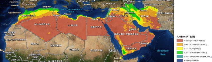
The Middle East and North Africa (MENA) region is considered the most water-scarce region of the world. Disputes over water lead to tension within communities, and unreliable water services are prompting people to migrate in search of better opportunities. Water investments absorb large amounts of public funds, which could often be used more efficiently elsewhere. As the region’s population continues to grow, per capita water availability is set to fall by 50 percent by 2050, and, if climate change affects weather and precipitation patterns as predicted, the MENA region may see more frequent and severe droughts and floods
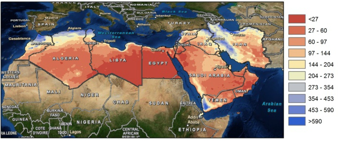
The need for alternative and improved water management options is therefore urgently needed, but a clear overview on what the main focus should be is lacking. A broad range of options exists which can be grouped by different approaches such as reducing the demand, increasing the supply, transfer between different sectors, transfer within different sectors, increase storage etc. An important aspect for the MENA region includes desalination.
To explore different options the World Bank initiated an initiative to generate an improved understanding of water issues in the region and overview of available options under different scenarios of water supply and demand management with special focus on desalination, taking into account the energy nexus and environmental concerns. As part of this initiative, FutureWater will carry out an assessment of water stress in the MENA region, including associated marginal cost of water supply to meet the water supply need. Conducting consultation workshops and meetings will be organized with relevant parties in the region (governmental, universities, civil society groups).
Water shortage is a growing concern and in response to this many countries are developing national water plans in an attempt to allocate water more effectively. In the Middle-East, where water is extremely scarce these water plans are considered as a means to improved water resources planning, but the plans are often based on limited information and data and are always very much focused on water in rivers and groundwater, rather than considering all the components of the water balance in the broader hydrological context. Weaknesses in these water plans often are:
1. Actual water use from irrigated areas is often assumed to be similar to water supplied.
2. There is an emphasis on increasing the so-called water efficiency rather than aiming at increasing water productivity.
3. Water consumption (=evaporation and transpiration) from natural vegetation or bare soils is not considered.
4. Groundwater recharge is poorly understood and based only on groundwater observation wells.
5. Net groundwater use, and to some extent surface water abstraction estimates are based on estimates of pumping hours and pump capacity rather than on actual abstractions.
6. Analysis is based on average conditions.
7. Water plans can be a reflection of preferred policies rather than based on unbiased analyses.
These issues make the estimated water consumption and the, from this derived, potential water allocations often unrealistic. It is however possible by using advanced remote sensing techniques to tackle most of the issues mentioned here. High resolution rainfall observations, accurate evapotranspiration estimates, and biomass production can be obtained at an unprecedented accuracy using remote sensing. Even changes in deep groundwater using changes in gravity fields can be monitored from remote sensing nowadays. Especially the high spatial coverage makes these remote sensing observations a unique product to support the national water plans.
Results based on completed studies in Tunisia, Egypt and Saudi-Arabia using advanced remote sensing techniques, are compared to information used in the national water plans of the three countries. This study assess to what extent these remote sensing observations can support the development of national water plans, improve the understanding of resource availability, better assess where water is consumed, and identify where losses are avoidable.
