Het meest recente onderzoek heeft zich gericht op het identificeren van historische megadroogtes op basis van paleo-gegevens en het begrijpen van hun klimatologische oorzaken, of op de studie van “moderne” gebeurtenissen en hun impact, meestal in laagland- en vlakke regio’s. Hooggebergteregio’s en sneeuwafhankelijke stroomgebieden zijn echter weinig bestudeerd, en er is weinig bekend over de impact van megadroogtes op de toestand en dynamiek van de cryosfeer in bergwatertorens.

Over het algemeen hebben stroomgebieden die afhankelijk zijn van hooggebergtesystemen een intrinsieke capaciteit om het gebrek aan neerslag en overmatige evapotranspiratie te bufferen, afhankelijk van de waterreserves opgeslagen in de cryosfeer (sneeuw, gletsjers en permafrost). Er wordt aangenomen dat deze buffercapaciteit beperkt is tot een kantelpunt wordt bereikt, waarna de impact van watertekorten en temperatuur-extremen kan worden versterkt en het functioneren van ecosystemen en watersystemen in gevaar kan brengen.

MegaWat heeft een dubbele doelstelling: 1) het aanpakken van kennisgebreken over de hydroklimatologische oorzaken van extreme droogtes en hun impact op de waterbalans van de bergwatertorens van Europa, met speciale nadruk op het samenvallen van samengestelde gebeurtenissen en cascade- en multischaleffecten, en 2) het ontwikkelen en voorstellen van nieuwe adaptatiestrategieën om om te gaan met de duur, omvang en ernst van toekomstige megadroogtes en hun potentiële impact op milieu- en sociaaleconomische activa.

Voor de uitvoering richt MegaWat zich op de hooggebergteregio’s van Europa en hun afhankelijke stroomgebieden. MegaWat streeft naar de ontwikkeling van drie producten:

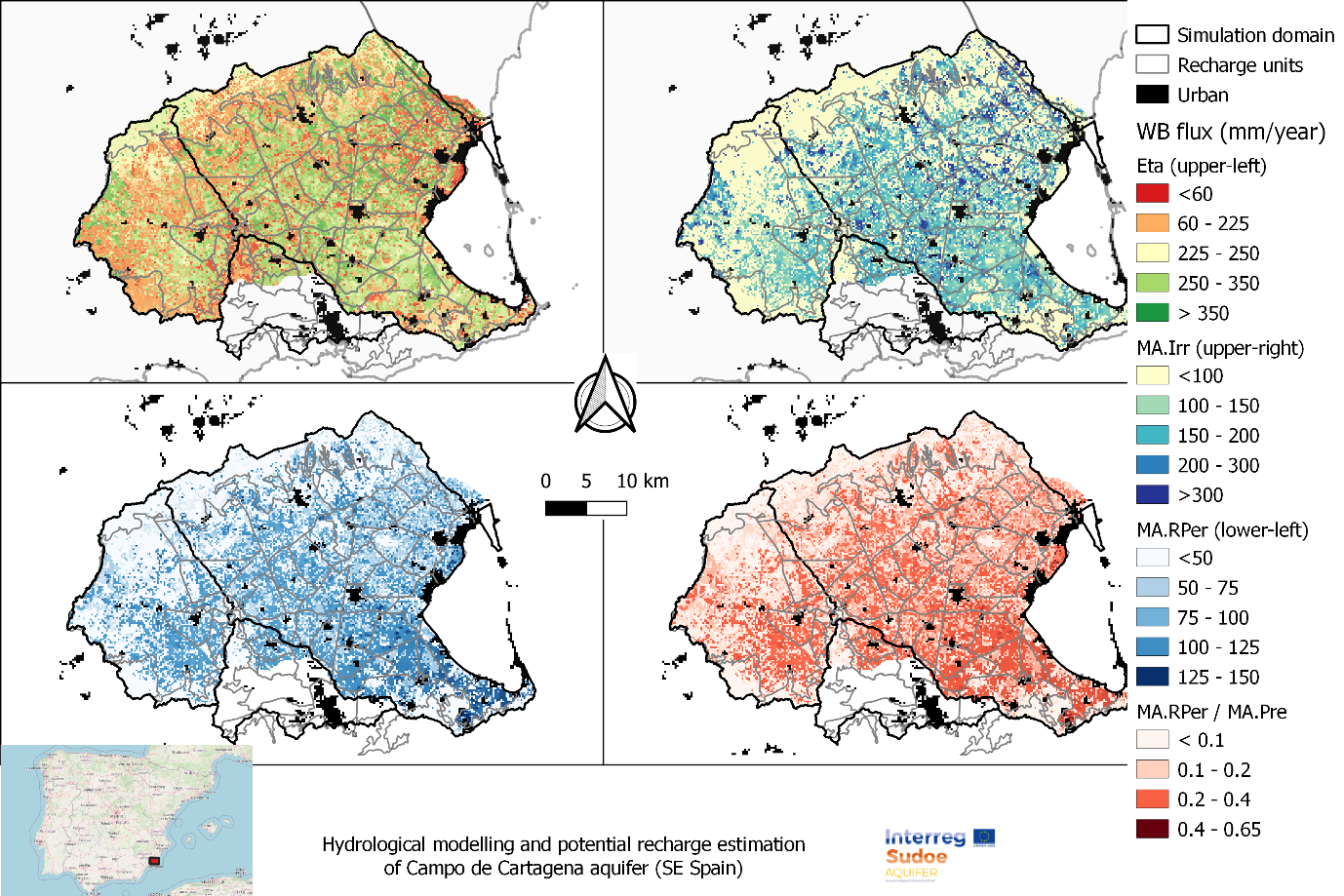
  • Product 1. Een methodologisch kader voor de identificatie en karakterisering van historische megadroogtes tijdens de instrumentele periode, en de beoordeling van de rol van de cryosfeer bij het ondersteunen van de landschapsontwikkeling van stroomafwaartse gebieden, of bij het bufferen van klimaatveranderingseffecten. Product 1 is gebaseerd op een combinatie van klimaatregionalisatie, modellering van de oppervlakte-energiebalans, hydrologische simulatie en analyse van waterevaluatie en -toewijzing op stroomgebiedniveau (zie onderstaande figuur).
  • Product 2. Een hoog-resolutie, open-toegang, geregionaliseerde klimaatdatabase.
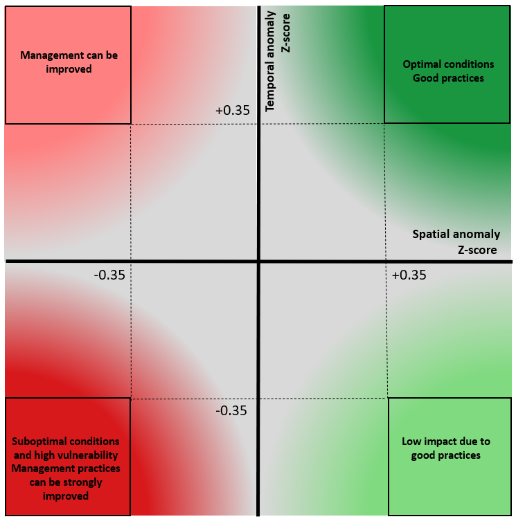
  • Product 3. Een lijst van potentiële adaptatiestrategieën die nuttig zijn voor de preventie en mitigatie van droogteeffecten, en voor de versterking van de waterveiligheid en veerkracht van hooggebergteregio’s en afhankelijke stroomgebieden. Deze scenario’s worden overeengekomen met regionale en lokale actoren en belanghebbenden, en hun effectiviteit wordt geëvalueerd onder extreme droogtescenario’s in drie pilotregio’s in Europa. Deze pilotregio’s worden vooraf geselecteerd op basis van criteria van representativiteit, strategisch belang en kwetsbaarheid voor droogtes.


Schematische weergave van een hooggebergtebekken, inclusief de belangrijkste componenten, processen en effecten gerelateerd aan droogtes.

FutureWater speelt een belangrijke rol in MegaWat door het coördineren van het werkpakket dat tot doel heeft simulatie-instrumenten te ontwikkelen en te testen die helpen bij de aanpassing aan megadroogtes en het ondersteunen van het besluitvormingsproces. Twee specifieke doelstellingen worden nagestreefd in dit werkpakket: a) de ontwikkeling van een methodologisch prototype voor het kwantificeren van impacten en het identificeren van kantelpunten voor waterveiligheid in sneeuwafhankelijke stroomafwaartse stroomgebieden, en b) de generatie en integratie van sneeuwdroogte-indicatoren in het Drought Early Warning System van FutureWater, genaamd InfoSequia (zie onderstaande figuur).

Workflow van het InfoSequia Early Warning System ontwikkeld door FutureWater en aangepast voor de detectie van kantelpunten van watertekort in sneeuwafhankelijke stroomgebieden. Meer informatie over InfoSequia.

Een one-pager kan hier worden gedownload.

Erkenningen

Dit project heeft financiering ontvangen van het Water4All-programma met cofinanciering van CDTI (Spaanse Dienst voor Wetenschap en Technologie) en het Horizon Europe-kaderprogramma van de EU voor onderzoek en innovatie.

Analysis of the historical climate data and future model projections indicates significant shifts in rainfall patterns. These shifts could influence water availability within the upstream river basins, which are vital for irrigation practices and ecological balance. Furthermore, the study explores variations in temperature -including average, minimum, and maximum values- and evaluates their potential consequences on water demand due to increased evaporation rates and altered crop water needs.

Additionally, this scoping research touches upon the effects of these climatic factors on olive crop phenology and productivity. The study also considers the likelihood of extreme weather events, such as heatwaves and droughts, and their potential to disrupt traditional farming cycles and water resource management strategies.

The outcomes of this analysis are aimed at providing an olive producing firm with insights and strategies to mitigate the adverse effects of climate change on olive production in these targeted regions of Andalucia. By foreseeing potential challenges and preparing for them, a decision can be made on whether to invest or not in order to maintain a leading olive producer on the global stage.

Southern Spain is a highly productive agricultural region, but with huge challenges around water scarcity and environmental sustainability. There is a demand in the agricultural sector to work towards water stewardship in Spain. The Alliance for Water Stewardship has developed a Standard which helps retailers and their suppliers to cause change at scale. This approach recognizes that there are common challenges that could be more easily overcome through a collective, place-based approach.

In the Doñana region, berry farms and groundwater usage are causing a conflict with the unique ecosystems in the National Park. A catchment assessment and active stakeholder engagement is needed as a first step in this region to work towards water stewardship. The catchment assessment will provide information on the catchment context, in line with the requirements of the Standard. The purpose of the assessment is to reduce the burden on agricultural sites by providing them with a common set of information which they and others can use to inform responses to their shared water challenges.

This consultancy project is framed by the AQUIFER project, “Innovative instruments for the integrated management of groundwater in a context of increasing scarcity of water resources” (Interreg-SUDOE V programme) which aims to capitalize, test, disseminate and transfer innovative practices for the preservation, monitoring and integrated management of aquifers.

FutureWater expertise was required for providing a novel and open-source hydrological modelling framework able to quantify spatial patterns of daily root percolation as a direct surrogate of groundwater recharge in the Campo de Cartagena Quaternary Aquifer (CC-QA). This aquifer is located at SE Spain and is one of the most important vectors of water drainage to the Mar Menor lagoon.

This task is addressed through the improvement and local calibration of the SPHY code for the Campo de Cartagena and the simulation of the water balance in the soil root zone from the 1950s until the end 2020. The SPHY-Campo de Cartagena includes a new routine able to compute irrigation inputs at the pixel level based on satellite data. Timeseries of monthly root percolation are taken as good surrogates of potential groundwater recharge and used as the main forcing input to an hydrogeological model of the Quaternary aquifer. The calibration process is performed through a sensititivity-intercomparison analysis in which model-derived outputs (irrigation and streamflow) during the calibration period are cross-checked against actual observations.

Spatial patterns of root percolation and the relative contribution of irrigation return flows to the total groundwater recharge were quantified (e.g. Figure 1) under historical and current conditions. Simulation results would show the lack of a significant temporal trend in the long-term recharge rates in the aquifer, most likely due to the the strong interannual variability observed in rainfall patterns, but also by the trade-offs resulting from the combination of climate, land use and irrigation-crop management drivers.

Figure 1. Mean Annual values of the main water balance components in Campo de Cartagena (2000-2020). RPer_ratio refers to the fraction between Root Percolation (MA.RPer) and Precipitation (MA.Pre)

FutureWater supports Fiera Comox in its due diligence process for the acquisition of a vertically integrated tree-fruit operation in North Spain. Particularly, FutureWater addresses an overall assessment of the most important water-related factors of risk that may control the current and medium-term feasibility of the fruit orchard farming system of interest. The application of FutureWater’s approach applies a multicriteria analysis and allows to qualify the levels of risk for each key factor analyzed.

FutureWater’s approach rests on: 1) the collection and analysis of data retrieved from documents, large datasets, and in-situ field inspections and stakeholder interviews, and 2) the scoring of the risks previously identified based on a final expert judgment.

Key sources of information for this risk screening included:

  • Existing documentation, reports, plans, and local legislation that may affect the access to water for irrigation
  • Existing and publicly accessible spatial and GIS data, including satellite imagery and thematic datasets available through national and regional agencies and platforms (Ebro River Basin Authority, National Infrastructure of Geospatial Data, Spanish Information System of Water)
  • Meteorological data (rainfall and temperature) from nearby weather stations
  • Groundwater level from the Spanish National Ministry of Environment.
  • Private data and documents generated by clients and stakeholders through personal and follow-up communications with farmer

Key variables analyzed and evaluated at the district and regional scales, to the extent relevant to the farm, included:

  • Water availability of surface and groundwater resources. For groundwater, a trend analysis of water levels, and first-order assessment of quality constraints and risks is included.
  • Impacts of climate change on water resources availability based on rainfall and temperature trends and projections for the region.
  • Water quality for irrigation purposes.
  • Potential conflicts due to competition for water in agriculture and other sectors of activity.

Legislative and policy-related factors that may affect the overall performance were also analyzed risk-by-risk.

Four factors of risk were analyzed: water availability, climate change, water quality, and water conflict. Each factor of risk was scored according to a risk matrix in which levels of probability of occurrence and impact severity were qualified based on data and expert judgement. For each factor, a risk matrix with three levels of overall risk were adopted: Low Risk (L), Moderate Risk (M), and High Risk (H)

Figure 1. Overall risk levels when probability of occurrence and impact severity are qualified.
Figure 2. Overview of risk assessment by factor.

In this particular project, the approach was implemented in four different settings located in the area.

De mediterrane regio staat voor groeiende uitdagingen om de voedsel- en watervoorziening te waarborgen, aangezien landen te maken krijgen met een toenemende vraag en een afnemende beschikbaarheid van natuurlijke hulpbronnen. De nexus-benadering is gericht op het beheren en benutten van synergieën tussen sectoren door middel van efficiënt en geïntegreerd beheer van de Water-, Energie-, Voedsel- en Ecosystemen-nexus (WEFE).

De doelstellingen van BONEX zijn het bieden van praktische en aangepaste hulpmiddelen, het onderzoeken van concrete en contextspecifieke technologische innovaties, het verbeteren van beleid en governance en het vergemakkelijken van de praktische implementatie van de WEFE-nexus, waarbij sociale, economische en ecologische afwegingen in balans worden gebracht.

Het project heeft als doel een nieuw, transdisciplinair diagnostisch WEFE-bridging framework te ontwikkelen, dat methoden op een contextspecifieke manier combineert en verder gaat dan disciplinaire silo’s. De diagnostische hulpmiddelen ter ondersteuning van dit framework zullen worden ontwikkeld en getest in zeven geselecteerde demonstratieprojecten in de regio, waarin innovatieve technologieën worden gepilot (zoals agrivoltaïsche systemen en systemen voor hergebruik van afvalwater).

Als resultaat zal BONEX beleidsmakers en praktijkmensen voorzien van een interactief besluitvormingsinstrument om afwegingen, synergieën en nexus-oplossingsbenaderingen op een transdisciplinaire manier te evalueren. Bovendien zal het waardevolle ervaringen opleveren met het op maat maken van innovatieve WEFE-nexus technologieën, wat nieuwe zakelijke kansen biedt. De WEFE-nexusbenadering is noodzakelijk om duurzame agrovoedselsystemen te implementeren en ecosystemen te behouden.

Binnen BONEX zal FutureWater actief bijdragen aan het pakket van diagnostische hulpmiddelen. Een eenvoudige waterboekhoudtool (REWAS) zal worden gebruikt om te evalueren of met innovatieve technologieën ‘echte waterbesparingen’ worden gerealiseerd. De waterboekhoudtool evalueert waterstromen op veldniveau en op schaal van irrigatiedistricten en bepaalt of er daadwerkelijk ‘echte besparingen’ worden behaald. De tool houdt ook rekening met voedselproductie (opbrengst van gewassen) en zal componenten introduceren voor het evalueren van energie- en waterkwaliteitsaspecten om de WEFE-nexusaspecten aan te vullen. De zeven demonstratieprojecten zullen worden gebruikt om deze waterboekhoudtool te demonstreren en iteratief te ontwikkelen. Een hydrologische analyse zal worden uitgevoerd op geselecteerde locaties om ook de impact op stroomgebiedschaal te evalueren. Uiteindelijk zullen de resultaten van deze analyses worden vertaald naar beleidsimplicaties en bijdragen aan de realisatie van de duurzame ontwikkelingsdoelen (SDG’s).

Dit project maakt deel uit van het PRIMA-programma, ondersteund door de Europese Unie.

Water and food security are at risk in many places in the world: now and most likely even more in the future, having large economic and humanitarian consequences. Risk managers and decision-makers, such as water management authorities and humanitarian-aid agencies/NGOs, can prevent harmful consequences more efficiently if information is available on-time on (1) the impact on the system, economy or society, and also (2) the probabilities for a failure in the system. EO information has proven to be extremely useful for (1). For looking into the future, considering the uncertainties, novel machine learning techniques are becoming available.

The proposed development is incorporated into an existing solution for providing Drought and Early Warning Systems (DEWS), called InfoSequia. InfoSequia is a modular and flexible toolbox for the operational assessment of drought patterns and drought severity. Currently, the InfoSequia toolbox provides a comprehensive picture of current drought status, based mainly on EO data, through its InfoSequia-MONITOR module. The proposed additional module, called InfoSequia-4CAST, is a major extension of current InfoSequia capabilities, responding to needs that have been assessed in several previous experiences.

InfoSequia-4CAST provides the user with timely, future outlooks of drought impacts on crop yield and water supply. These forecasts are provided on the seasonal scale, i.e. 3-6 months ahead. Seasonal outlooks are computed by a novel state-of-the-art Machine Learning technique. This technique has already been tested for applications related to crop production forecasting and agricultural drought risk financing. The FFTrees algorithm uses predictor datasets (in this case, a range of climate variability indices alongside other climatic and vegetative indices) to generate FFTs predicting a binary outcome – crop yields or water supply-demand balance above or below a given threshold (failure: yes/no).

The activity includes intensive collaboration with stakeholders in Spain, Colombia and Mozambique, in order to establish user requirements, inform system design, and achieve pilot implementation of the system in the second project year. Generic machine learning procedures for training the required FFTs will be developed, and configured for these pilot areas. An intuitive user interface is developed for disseminating the output information to the end users. In addition to development of the forecasting functionality, InfoSequia-MONITOR will be upgraded by integrating state-of-the art ESA satellite data and creating multi-sensor blended drought indices.

This project is part of the technical-innovation support provided by FutureWater to ECOPRADERAS, an EIP-AGRI Operational Group led by Ambienta Ing. and co-funded by the EU and the Spanish Ministry of Agriculture. As a general objective, ECOPRADERAS aims to improve the sustainable management of grasslands located at the Alagon Valley (Extremadura, Spain) through: (1) the transfer and implementation of innovative technologies, (2) the identification and strengthening of good cultural practices, and (3) the dissemination of the most relevant information and results among end users.

In the frame of ECOPRADERAS, FutureWater is tasked with the development of an operational monitoring tool able to inform, at the regional scale, on the health status of the grasslands by using satellite data of moderate spatial resolution. The ECOPRADERAS monitor includes the following innovative features:

  • Generation of a categorical index indicative of the health status of grasslands based on the combination of indices of spatial and temporal greenness anomalies.
  • Higher spatial details by using satellite images of moderate spatial resolution (collection of Landsat-8TM of 30 m resolution)
  • Large improvement for collecting and processing large satellite datasets by using the Google Earth Engine cloud-based geoprocessing platform (collection of Landsat-8TM from January 2014 onwards)
  • A user friendly web-mapping interface to visualize outputs

The methodology used by FutureWater uses massive data processing technologies in the cloud (Google Earth Engine) to compute a pixel-based categorical index that result of the combination of a spatial and a temporal anomaly of the greenness index (NDVI). After a local calibration that needs to be adopted, this qualitative index, called the Combined Index of Normalized Anomalies (ICAN) (figure), classifies the status of grasslands in the region of interest into different categories that informs on the health grasslands and how are they being managed. With the ICAN, land managers and local actors can early detect those portions in the landscape in which management practices may pose a risk for the sustainability of the agropastoral system and then would require special attention for improving them.

Logic diagram for computing the Combined Index of Normalized Anomalies (ICAN) in the ECOPRADERAS Monitor.The specific tasks developed by FutureWater included: the definition of a methodological framework for monitor the health of grasslands at the regional scale, the design of a processing and web-mapping platform and its practical implementation in the Alagon Valley (182 km2) from September 2019 to July 2020, and the calibration-validation of the results by comparing outputs with field observations collected in different pilot sites by other project partners.

An evaluation of the results points out to the strength of the methodology. The processing architecture is also easily scalable to other regions and rangeland landscapes. Further improvements have been also envisioned. The ECOPRADERAS Monitor stands as a very powerful tool to guide landscape managers local stakeholders on better decisions.

ECOPRADERAS Monitor at the Alagon Valley (Extremadura, Spain)

Groundwater is one of the most important freshwater resources for mankind and for ecosystems. Assessing groundwater resources and developing sustainable water management plans based on this resource is a major field of activity for science, water authorities and consultancies worldwide. Due to its fundamental role in the Earth’s water and energy cycles, groundwater has been declared as an Essential Climate Variable (ECV) by GCOS, the Global Climate Observing System. The Copernicus Services, however, do not yet deliver data on this fundamental resource, nor is there any other data source worldwide that operationally provides information on changing groundwater resources in a consistent way, observation-based, and with global coverage. This gap will be closed by G3P, the Global Gravity-based Groundwater Product.

The G3P consortium combines key expertise from science and industry across Europe that optimally allows to (1) capitalize from the unique capability of GRACE and GRACE-FO satellite gravimetry as the only remote sensing technology to monitor subsurface mass variations and thus groundwater storage change for large areas, (2) incorporate and advance a wealth of products on storage compartments of the water cycle that are part of the Copernicus portfolio, and (3) disseminate unprecedented information on changing groundwater storage to the global and European user community, including European-scale use cases of political relevance as a demonstrator for industry potential in the water sector. In combination, the G3P development is a novel and cross-cutting extension of the Copernicus portfolio towards essential information on the changing state of water resources at the European and global scale. G3P is timely given the recent launch of GRACE-FO that opens up the chance for gravity-based time series with sufficient length to monitor climate-induced and human-induced processes over more than 20 years, and to boost European space technology on board these satellites.

In this project, FutureWater is in charge of a case which aims to prototype and calibrate a Groundwater Drought Index based on the G3P product, and to integrate it into InfoSequia, the FutureWater’s in-house Drought Early Warning System. The new InfoSequia component will be tested for inherent reliability and flexibility at the basin level in a total area of about 145 000 km2 in Southern Spain which largely relies on groundwater resources. This pilot region comprises three large basins (Segura, Guadalquivir and Guadiana) with many aquifers and groundwater bodies where very severe dynamics of overexploitation and mining have been identified and declared. Unsustainable groundwater development threats the water security in the region, but also the ecological status and preservation of unique and highly protected ecosystems in Europe (e.g., Doñana National Park, Daimiel National Park, Mar Menor coastal lagoon).

To visit the official G3P website, please click on this link: https://www.g3p.eu

Project description

The groundwater discharge of irrigation return flows to the Mar Menor lagoon (Murcia, SE Spain), the largest coastal lagoon in Europe, is among one of the possible causes that would explain the high levels of eutrophication (hypereutrophication) and the several algal blooms accounted in this lagoon ecosystem in the last years. Previous studies, led and/or participated by FutureWater staff (e.g. Contreras et al., 2014; Jiménez-Martínez et al., 2017) suggest that the contribution of groundwater discharges from the Quaternary aquifer to the Mar Menor would reach values much higher than the ones officially recognized.

The construction of subsurface drainage system to intersect the groundwater flows in the surroundings of the lagoon is one of the potential solutions proposed to reduce the load of polluted groundwaters that reach the Mar Menor (Figure 1). Once pumped, these waters can be again reused for irrigation after a desalination and denitrification treatment. A large network of subsurface drainage channels are being currently operated by the Arco Sur-Mar Menor Irrigator Association (Arco Sur IA).

Flows and relationship between the Campo de Cartagena Quaternaty aquifer and the Mar Menor lagoon with (left panel) and without (left panel) a subsurface drainage system.

The Arco-Sur IA has commissioned FutureWater, in collaboration with Hydrogeomodels, this project in order to evaluate the usefulness of these infrastructures, and to explore the possibilities of extending them to the rest of the Campo de Cartagena region. The use of numerical modelling to simulate the groundwater dynamics in the Quaternary aquifer, and to quantify the spatial patterns of groundwater discharge to the Mar Menor lagoon would help to demonstrate the effectiveness of these type of infrastructures, but also to evaluate the best locations and exploitation regimes possible to reduce the discharges to the Mar Menor without compromising the provision of other ecosystem services (e.g. ecological status of coastal wetlands).

The development and calibration of the hydrogeological model for the Quaternary aquifer of the Campo de Cartagena has been rested on an intense collection of all the data available in the region, and their integration with the most advanced hydrological and hydrogeological simulation techniques. This hydrogeological model is considered a key tool to support decision making, and to evaluate the potential effectiveness of different water management strategies proposed for the region (pumping batteries, drainage networks), but also for assessing the potential impacts that would emerge due to land cover and climate change scenarios.

Objective and Methods

The objective of this study is to quantify the water balance in the Campo de Cartagena, to simulate the groundwater flow regime in the Quaternary aquifer, and to evaluate the spatial pattern of groundwater discharge to the Mar Menor lagoon for average and extreme hydrological conditions, through the calibration and implementation of a hydrogeological model.

The project has been organized into four tasks (Figure 2): 1) collection and processing of input data, 2) hydrological modeling, 3) hydrogeological modeling, and 4) reporting and and outreach activities.

Methodological diagram and execution phases.