The Middle East and North Africa (MENA) region is considered the most water-scarce region of the world. Disputes over water lead to tension within communities, and unreliable water services are prompting people to migrate in search of better opportunities. Water investments absorb large amounts of public funds, which could often be used more efficiently elsewhere. As the region’s population continues to grow, per capita water availability is set to fall by 50 percent by 2050, and, if climate change affects weather and precipitation patterns as predicted, the MENA region may see more frequent and severe droughts and floods
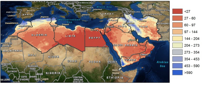
Map of yearly average precipitation in the MENA region (mm).
The need for alternative and improved water management options is therefore urgently needed, but a clear overview on what the main focus should be is lacking. A broad range of options exists which can be grouped by different approaches such as reducing the demand, increasing the supply, transfer between different sectors, transfer within different sectors, increase storage etc. An important aspect for the MENA region includes desalination.
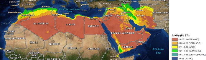
Map of aridity in the MENA region.
To explore different options the World Bank initiated an initiative to generate an improved understanding of water issues in the region and overview of available options under different scenarios of water supply and demand management with special focus on desalination, taking into account the energy nexus and environmental concerns. As part of this initiative, FutureWater will carry out an assessment of water stress in the MENA region, including associated marginal cost of water supply to meet the water supply need. Conducting consultation workshops and meetings will be organized with relevant parties in the region (governmental, universities, civil society groups).
Water shortage is a growing concern and in response to this many countries are developing national water plans in an attempt to allocate water more effectively. In the Middle-East, where water is extremely scarce these water plans are considered as a means to improved water resources planning, but the plans are often based on limited information and data and are always very much focused on water in rivers and groundwater, rather than considering all the components of the water balance in the broader hydrological context. Weaknesses in these water plans often are:
1. Actual water use from irrigated areas is often assumed to be similar to water supplied.
2. There is an emphasis on increasing the so-called water efficiency rather than aiming at increasing water productivity.
3. Water consumption (=evaporation and transpiration) from natural vegetation or bare soils is not considered.
4. Groundwater recharge is poorly understood and based only on groundwater observation wells.
5. Net groundwater use, and to some extent surface water abstraction estimates are based on estimates of pumping hours and pump capacity rather than on actual abstractions.
6. Analysis is based on average conditions.
7. Water plans can be a reflection of preferred policies rather than based on unbiased analyses.
These issues make the estimated water consumption and the, from this derived, potential water allocations often unrealistic. It is however possible by using advanced remote sensing techniques to tackle most of the issues mentioned here. High resolution rainfall observations, accurate evapotranspiration estimates, and biomass production can be obtained at an unprecedented accuracy using remote sensing. Even changes in deep groundwater using changes in gravity fields can be monitored from remote sensing nowadays. Especially the high spatial coverage makes these remote sensing observations a unique product to support the national water plans.
Results based on completed studies in Tunisia, Egypt and Saudi-Arabia using advanced remote sensing techniques, are compared to information used in the national water plans of the three countries. This study assess to what extent these remote sensing observations can support the development of national water plans, improve the understanding of resource availability, better assess where water is consumed, and identify where losses are avoidable.