I-DIP is gebaseerd op InfoSequia, een geavanceerde toolkit die satellietgegevens, lokale waarnemingen en machine learning integreert om droogtes te monitoren en te voorspellen. Er zal een nieuwe indicator voor flitsdroogte, aangepast aan het Pakistaanse klimaat, worden ontwikkeld en geïntegreerd in het bestaande NDMC-systeem. Het project zal de mogelijkheden voor vroegtijdige waarschuwing verbeteren, de voedsel- en waterzekerheid waarborgen en bijdragen aan de nationale inspanningen voor klimaatadaptatie, waardoor de weg wordt vrijgemaakt voor de uitbreiding van het I-DIP in heel Pakistan.

Naast monitoring zal het I-DIP zijn voorspellingen koppelen aan besluitvormingsinstrumenten. Informatie over de gevolgen zal worden verspreid via nieuwsbrieven en de inFarmer-applicatie (ontwikkeld door WaterSprint), die al op grote schaal wordt gebruikt door boerengemeenschappen. Veldmedewerkers van het Better Cotton Initiative zullen deze kennis vertalen naar praktische richtlijnen voor boeren, zodat ze irrigatiepraktijken kunnen aanpassen, teeltkalenders kunnen bijstellen en potentiële verliezen kunnen beperken. Deze integratie van geavanceerde droogtewetenschap met gevestigde communicatienetwerken zorgt ervoor dat vroegtijdige waarschuwingen worden omgezet in praktische acties in het veld.

Door I-DIP te integreren in het operationele systeem van de NDMC versterkt het project direct de vroegtijdige waarschuwingscapaciteit voor droogte in Pakistan, sluit het aan bij het nationale klimaatbeleid en ondersteunt het de toezeggingen van het land in het kader van de Sustainable Development Goals. Op de lange termijn zal het proefproject naar verwachting de schaalvergroting van I-DIP in heel Pakistan katalyseren, waardoor de autoriteiten de beschikking krijgen over een geavanceerd instrument om te anticiperen op deze extreme gebeurtenissen en ze te beheersen.

With the highest rate of urbanization in South Asia and as one of the most vulnerable countries to climate change, Pakistan faces a range of complex challenges, including more frequent and intense flooding, declining economic productivity, and deteriorating public services. Growing dependence on groundwater, coupled with insufficient surface water recharge, is leading to severe localized groundwater depletion.

With support from the Asian Development Bank, the Government of Pakistan aims to upgrade and expand water and sanitation infrastructure in the cities of Sargodha and DG Khan, both of which face significant climate change-related challenges that impact combined drainage and sewer networks. The project has three major outputs:

  1. improving climate-resilient urban infrastructure and services,
  2. enhancing institutional capacity, operational efficiency, and gender inclusiveness of service providers, and
  3. creating greater economic empowerment opportunities for women in the WASH sector.

To assess the exposure and vulnerabilities of project components to potential climate risks, FutureWater will utilize advanced downscaled Coupled Model Intercomparison Project Phase 6 (CMIP6) ensembles, along with relevant hazard data and local information, to conduct a detailed Climate Risk Assessment (CRA). The insights gained will enable the Asian Development Bank (ADB) to implement effective adaptation measures and ensure climate-resilient development.

Currently, Pakistan’s energy mix consists of 58.8% thermal, 25.8% hydel, 8.6% nuclear, and 6.8% alternative sources, reflecting efforts to diversify from fossil fuels. Pakistan’s installed electricity generation capacity reached 41,557 MW by 2022, with significant growth in transmission line length over the past 5 years. However, the T&D system has not kept pace with the nearly 15,000 MW capacity added during 2017-2021 (ADB, 2024). Despite investments, transmission and distribution losses averaged about 18% over the last 5 years, exceeding the National Electric Power Regulatory Authority’s (NEPRA) 15.3% target. In 2020, 23.7% of generated energy was lost during transmission, distribution, and delivery (ADB, 2024). Notably, transmission and distribution losses exceed 25%, far higher than in comparable countries (GoP, 2017). Therefore, there is an urgent need to upgrade the existing distribution infrastructure to fulfill the energy demands and ensure steady socioeconomic development in the country. ADB will provide financing for four underperforming DISCOs, selected in consultation with the Ministry of Energy: Sukkur Electric Power Company (SEPCO), Hyderabad Electric Supply Company (HESCO), the Multan Electric Power Company (MEPCO), and the Lahore Electric Supply Company (LESCO) to:

  1. to upgrade the critical infrastructure of these DISCOs to reduce technical losses.
  2. to implement revenue protection measures to improve collections. Additionally, the project design includes embedded climate resilience and reform measures to enhance institutional capacity and financial sustainability.

These rehabilitation efforts will also take into account and address the growing impacts of climate change in four DISCOs. FutureWater will make use of state-of-the-art downscaled Coupled Model Intercomparison Project Phase 6 (CMIP6) ensembles, and other relevant hazards and local information to develop this CRA. Insights from the CRA will be used to devise adaptation strategies. Additionally, FutureWater will be reviewing the existing meteorological monitoring network and recommending additional potential monitoring sites for improved surveillance in the country. To further assist the Government of Pakistan, in actualizing its second Nationally Determined Contribution (NDC) agenda which seeks to reduce greenhouse gas (GHG) emissions per unit of GDP by 50% (compared to the level in 2016), by the year 2030, FutureWater will also develop a GHG account and prepare a Paris Agreement alignment assessment.

The project prepares robust climate mitigation and adaptation pipelines aligned with the Paris Agreement and responsive to DMCs climate change priorities. The TA will support interventions on departmental, sectoral and country levels with key activities including development of a regional strategy, upstream climate assessments, climate pipeline development, government dialogues and capacity building. As part of this project, FutureWater conducts a regional climate risk assessment for ten countries. This includes an assessment of baseline and future climate hazards, exposure and vulnerability and addressing sectoral impacts and adaptation options for a wide range of sectors. In addition country profiles summarizing climate risks for the ten countries are generated. The reginal climate risk assessment feeds into the climate strategy.

Agriculture is the most water demanding and consuming sector, globally responsible for most of the human induced water withdrawals. This abstraction of water is a critical input for agricultural production and plays an important role in food security as irrigated agriculture represents about 20 percent of the total cultivated land while contributing by 40 percent of the total food produced worldwide.

The FAO Regional Office for Asia and the Pacific (FAO-RAP) is concerned about this increase in water use over the last decades that has led to water scarcity in many countries. This trend will continue as the gap between water demand and supply is projected to widen due to factors such as population growth and economic development, and environmental factors such as land degradation and climate change.

Unfortunately, solutions to overcome the current and future water crisis by looking at the agricultural sector are not simple and have often led to unrealistic expectations. Misconceptions and overly simplistic (and often erroneous) views have been flagged and described over the last recent decades. However, uptake of those new insights by decision makers and the irrigation sector itself has been limited.

The “Follow the Water” project will develop a Guidance Document that summarizes those aspects and, more importantly, quantifies the return flows that occurs in irrigated systems. Those return flows are collected from a wide range of experiments and are collected in a database to be used as reference for new and/or rehabilitation irrigation projects.

The FAO/FutureWater project will also develop a simple-to-use tool to track water in irrigated systems using so-called “virtual tracers”. The tool will respond to the demand for a better understanding the role of reuse of water in irrigated agriculture systems. An extensive training package, based on the Guidance and the Tool, is developed as well.

FAO plays an essential role in backstopping the development of the Guidance and the Tool and promoting. FutureWater takes the lead in development of the Guidance, the Tool and the training package. With this, FAO and FutureWater will contribute to a sustainable future of our water resources.

Pakistan is ranked as the 8th most climate vulnerable country in the world as per the Global Climate Risk Index (2019) and in recent years has been facing the worst brunt of climate change. Irregular and intense precipitation, heatwaves, droughts, and floods have severely impacted the agriculture and water sector. Approximately, 90% of the country’s freshwater resources are utilized by the agricultural sector. However, lack of information services makes it a challenge to implement a water accounting system for improved water resources management.

The GCF funded project titled “Transforming the Indus Basin with Climate Resilient Agriculture and Water Management” aims to shift agriculture and water management to a new paradigm in which processes are effectively adapting to climate change and are able to sustain livelihoods. FAO Pakistan, as per the request of the Ministry of Climate Change, has designed the project to develop the country’s capacity to enhance the resilience of the agricultural and water sector. There are three major components:

1. Enhancing information services for climate change adaptation in the water and agriculture sectors
2. Building on-farm resilience to climate change
3. Creating an enabling environment for continued transformation

FutureWater will be actively involved in Component 1 which focuses on facilitating the development of a water accounting system and improving the availability and use of information services. Given the limited data availability in the region, FutureWater will integrate the use of remote sensing technologies within the existing Water Accounting methodology to address this gap. A capacity and needs assessment will be conducted and a series of tailor-made trainings will be designed subsequently to enable key government stakeholders to use open-source geospatial analysis tools as well as models to estimate real water savings, particularly in the context of agriculture. The trainings will help build the country’s capacity to implement water accounting at different spatiotemporal scales and cope with the worsening impacts of climate change.

The SREB is part of the Belt and Road Initiative, being a development strategy that focuses on connectivity and cooperation between Eurasian countries. Essentially, the SREB includes countries situated on the original Silk Road through Central Asia, West Asia, the Middle East, and Europe. The initiative calls for the integration of the region into a cohesive economic area through building infrastructure, increasing cultural exchanges, and broadening trade. A major part of the SREB traverses Asia’s high-altitude areas, also referred to as the Third Pole or the Asian Water Tower. In the light of the planned development for the SREB traversing the Third Pole and its immediate surroundings, the “Pan-Third Pole Environment study for a Green Silk Road (Pan-TPE)” program will be implemented.

The project will assess the state and fate of water resources in the region under following research themes:

1. Observed and projected Pan-TPE climate change
2. Impacts on the present and future Water Tower of Asia
3. The Green Silk Road and changes in water demand
4. Adaptation for green development

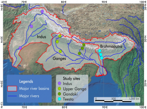
HI-AWAREHI-AWARE is one of four consortia of the Collaborative Adaptation Research Initiative in Africa and Asia (CARIAA). HI-AWARE aims to contribute to enhanced adaptive capacities and climate resilience of the poor and vulnerable women, men, and children living in the mountains and flood plains of the Indus, Ganges, and Brahmaputra river basins through the development of robust evidence to inform people-centred and gender-inclusive climate change adaptation policies and practices for improving livelihoods.
HI-AWARE will:

  • Generate scientific knowledge on the biophysical, socio-economic, gender, and governance conditions and drivers leading to vulnerability to climate change;
  • Develop robust evidence to improve understanding of the potential of adaptation approaches and practices, with an explicit focus on gender and livelihoods;
  • Develop stakeholder-driven adaptation pathways based on the up- and out-scaling of institutional and on-the-ground adaptation innovations;
  • Promote the uptake of knowledge and adaptation practices at various scales by decision-makers and citizens; and
  • Strengthening the interdisciplinary expertise of researchers, students, and related science-policy-stakeholder networks.

HI-AWARE study sites

HI-AWARE will focus its activities in 12 sites, representing a range of climates, altitudes, hydro-meteorological conditions, rural-urban continuum, and socio-economic contexts in four study basins: the Indus, Upper Ganga, Gandaki and Teesta. It will conduct research in these sites, including modeling, scoping studies, action research, and randomized control trials. It will test promising adaptation measures in observatory labs at the sites for out-scaling and up-scaling. It will also conduct participatory monitoring and assessment of climate change impacts and adaptation practices to identify:

  • Critical moments – times of the year when specific climate risks are highest and when specific adaptation interventions are most effective;
  • Adaptation turning points – adaptation turning points – when current policies and management practices are no longer effective and alternative strategies have to be considered; and
  • Adaptation pathways – sequences of policy actions that respond to adaptation turning points by addressing both short term responses to climate change and longer term planning.

FutureWater’s main tasks focus on biophysical drivers and conditions leading to vulnerability to climate change. Key tasks are to:

  • Develop detailed mountain specific and basin scale climate change scenarios;
  • Improve cryosphere-hydrological modeling to assess significant shifts in flow regimes with an aim to develop water demand and supply scenarios as well as improve and apply water-food impact models; and
  • Better understand climate change impacts on extremes (heat, floods, drought),and quantify these extremes from climate models and subsequently impact models.

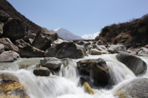
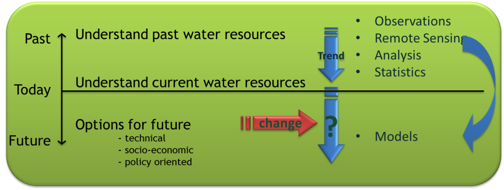
Water is becoming an increasingly critical factor in Asia. The catchments of Hindu – Kush Himalayan (HKH) are a source of a significant portion of this water. Glaciers are a component of the HKH water budget. There is general agreement that a widespread retreat of the global ice cover has been occurring since at least the late 1800s. However, a consensus view of the significance of this retreat in terms of factors determining glacier mass balance, or the resulting water resources and general environmental impacts has not been reached for the HKH mountains. It is believed that only a combined effort of local observation, remote sensing and simulation modeling can lead to a better understanding of what’s happening. Especially the modeling is essential to provide projections for the future.

FutureWater has conducted a review of current state of knowledge in (i) climate change datasets and downscaling used for glacier and high mountain modelling, (ii) glacier and snow contribution to river runoff in the HKH region, (iii) hydrological modelling studies used for glacier and high mountain environments and, (iv) downstream impacts of climate change on the HKH region.

The concept of using simulation models in scenario analysis.
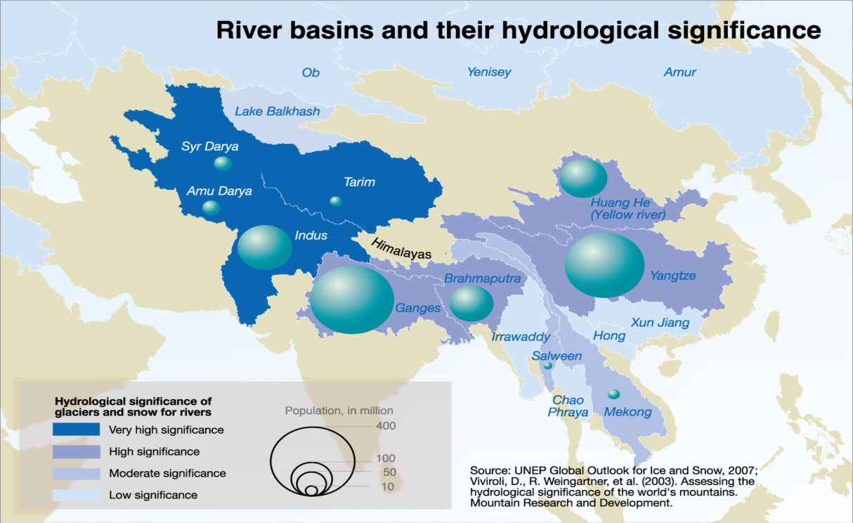
Importance of Himalayan’s rivers for people.

The Indus basin is a densely populated area and water supplied by the Indus River is extremely important for agriculture, domestic use and hydropower production. The Indus is largely dependent on melt water generated in the Himalayas, Karakoram and Hindu Kush mountains. Understanding of the hydrological regimes in the mountainous Upper Indus basin (UIB) is essential for water resources management in the region.

It is highly likely that future climate change will impact future water availability in the Upper Indus river basin. Temperature increases and changes in the timing, magnitude, and phase of precipitation will alter the timing and contribution of snow and ice melt.

High-resolution gridded meteorological datasets, which capture the spatial variability of precipitation, are critical for modelling the hydrology of high-mountain regions. In the Upper Indus Basin (UIB), previous modelling studies have demonstrated that snow and glacier melt are major contributors to stream discharge, and on daily or seasonal scales can play even larger roles. However, hydrologic models suffer from a lack of gridded input climate data which accurately reflects the topographic complexity and spatial variability in precipitation. Improvements to existing gridded datasets using high-elevation station data will increase the reliability of hydrological models in the region. FutureWater’s Spatial Processes in Hydrology (SPHY) model will be updated and recalibrated to improve understanding of the stream flow composition in the basin and to provide better estimates of the future water availability, by forcing the model with downscaled CMIP5 general circulation models.

Summarizing, the three main goals of the project are:

  • To develop a high-quality meteorological forcing dataset (temperature and precipitation) for the UIB by merging existing gridded datasets and high-altitude climate observations.
  • To improve the existing large-scale SPHY model by including a reservoir scheme and recalibrating the model with additional observations (geodetic mass balance, time series of river runoff, time series of reservoir inflow data).
  • To use the recalibrated SPHY model to examine shifts in the basin hydrology under CMIP5 climate change scenarios.