Binnen 3POLE4FOOD draagt FutureWater bij aan de beoordeling van de langetermijngevolgen van klimaatverandering voor de waterbeschikbaarheid en de gewasproductie in belangrijke Aziatische stroomgebieden. Het project combineert modellering van berghydrologie met modellering van stroomafwaartse hydrologie en gewasproductie om beter te begrijpen hoe veranderingen in sneeuw, gletsjersmelt, neerslag en temperatuur de irrigatiewatervoorziening en de landbouwproductie beïnvloeden.

FutureWater leidt belangrijke technische activiteiten met betrekking tot klimaatforcering, biascorrectie van meteorologische datasets en het genereren van klimaatveranderingsscenario’s. Samen met Hydrominds en de Universiteit van Wageningen voeren we glacio-hydrologische modellering uit en analyseren we de waterverbindingen tussen stroomopwaartse en stroomafwaartse gebieden. Met behulp van het SPHY-model worden historische en toekomstige afvoeren uit berggebieden gesimuleerd, inclusief de bijdragen van neerslag, smeltwater uit sneeuw en gletsjers. Deze resultaten worden gekoppeld aan het LPJmL-model om de waterbeschikbaarheid stroomafwaarts, de irrigatiebehoefte, de gewasopbrengsten en de waterproductiviteit van gewassen te beoordelen onder toekomstige klimaat- en sociaal-economische scenario’s.

Het project biedt een wetenschappelijke basis voor het identificeren van risicogebieden en het inzichtelijk maken waar landbouwsystemen kwetsbaarder kunnen worden voor veranderingen in de watervoorziening uit berggebieden. Door klimaat, hydrologie en voedselproductie met elkaar te verbinden, ondersteunt 3POLE4FOOD een op bewijs gebaseerde planning voor veerkrachtige stroomgebieden en duurzame voedselsystemen in Azië.

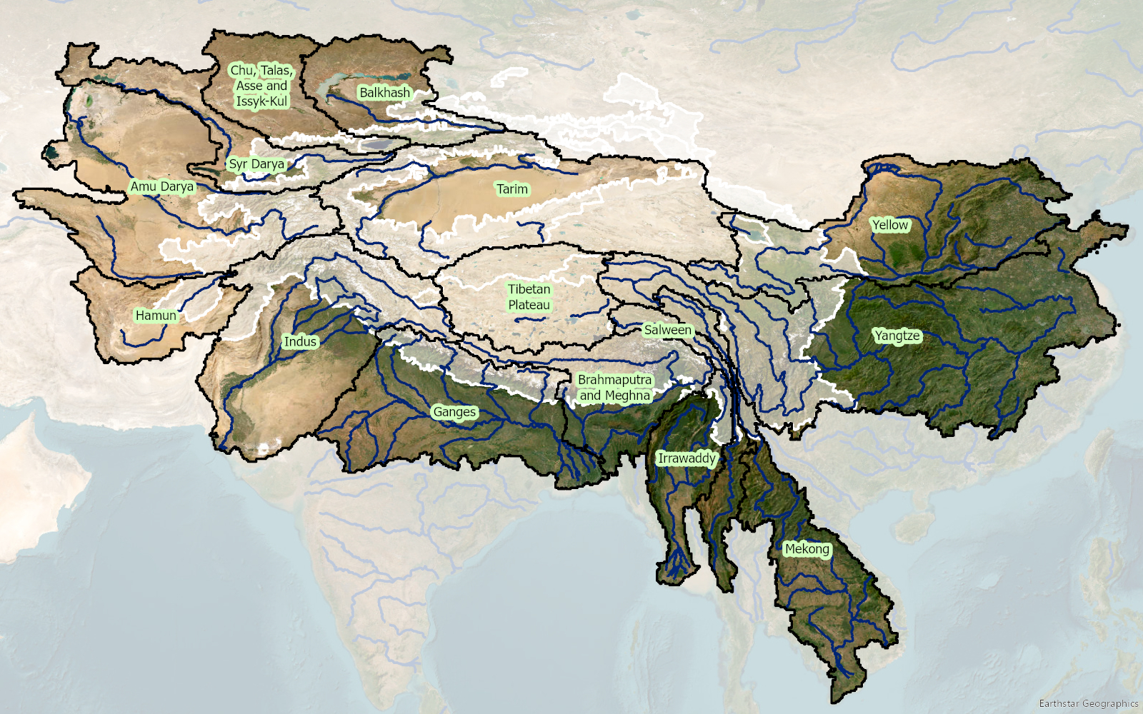
Stroomgebieden die hun oorsprong vinden in de hoge bergen van Azië en die deel uitmaken van het 3POLE4FOOD-project. De witte veelhoek geeft de delen in de hoge bergen aan.

Countries in Asia and the Pacific region are significantly exposed to disaster risks from various hazards and are on the frontline of a climate emergency. Studies suggest that 80% of the globally affected people belong to the Asia-Pacific region, thus emphasizing the critical need for an effective multi-hazard EWS.

EWS, a cost-effective tool for saving lives and reducing economic losses, is particularly crucial for frequent and hazardous weather, water, and climate events. However, despite advancements in the four EWS components, major gaps persist, with implementation lagging and limited coverage in frontline countries, including least developed countries (LDCs) and small island developing states (SIDS). As of 2021, only 50% of countries in Asia and the Pacific reported having multi-hazard early warning systems (MHEWS), emphasizing the need for support.

The culmination of these efforts will be encapsulated in a scoping report, documenting the results of the project, including consultations with key partners and stakeholders during the Regional Workshop on Increasing Investments in Early Warning Systems, to be held in February 2024 in Bangkok, Thailand. The study will offer a comprehensive summary of the EWS scoping, encompassing the policy and institutional landscape, status, initiatives, and investments, as well as residual gaps for regional and national EWS programming in selected DMCs. Additionally, this study will provide guidelines for the implementation and operationalization of the proposed EWS facility, along with initial investment concept notes based on EWS priorities at regional and/or national levels. This holistic approach aims to contribute substantively to the strengthening of EWS capacities, fostering resilience in the face of increasing disaster risks across the region.

Nepal biedt een ideale proeftuin vanwege de sterke overheidssteun voor klimaatslimme landbouw, een grote populatie kwetsbare kleine boeren en de actieve betrokkenheid van organisaties zoals het Climate Resilience Research Centre (CRRC) en het International Centre for Integrated Mountain Development (ICIMOD). De resultaten van deze haalbaarheid zullen nationale beleidsdoelstellingen ondersteunen en kunnen worden opgeschaald naar vergelijkbare berggebieden in Zuid-Azië.

Dit project richt zich op het Syangja-district in de provincie Gandaki, dat te kampen heeft met toenemende waterschaarste en onvoorspelbare regenval, met name op bergboerderijen die afhankelijk zijn van bronirrigatie en regenlandbouw. Deze omstandigheden maken traditionele irrigatie onrendabel en creëren een behoefte aan betaalbare en lokaal aanpasbare lagedrukoplossingen. De slimme sproeier combineert praktische hardware met een digitale adviestool om het beperkte watergebruik te optimaliseren: een zuinige innovatie op maat van de behoeften van kleine boeren.

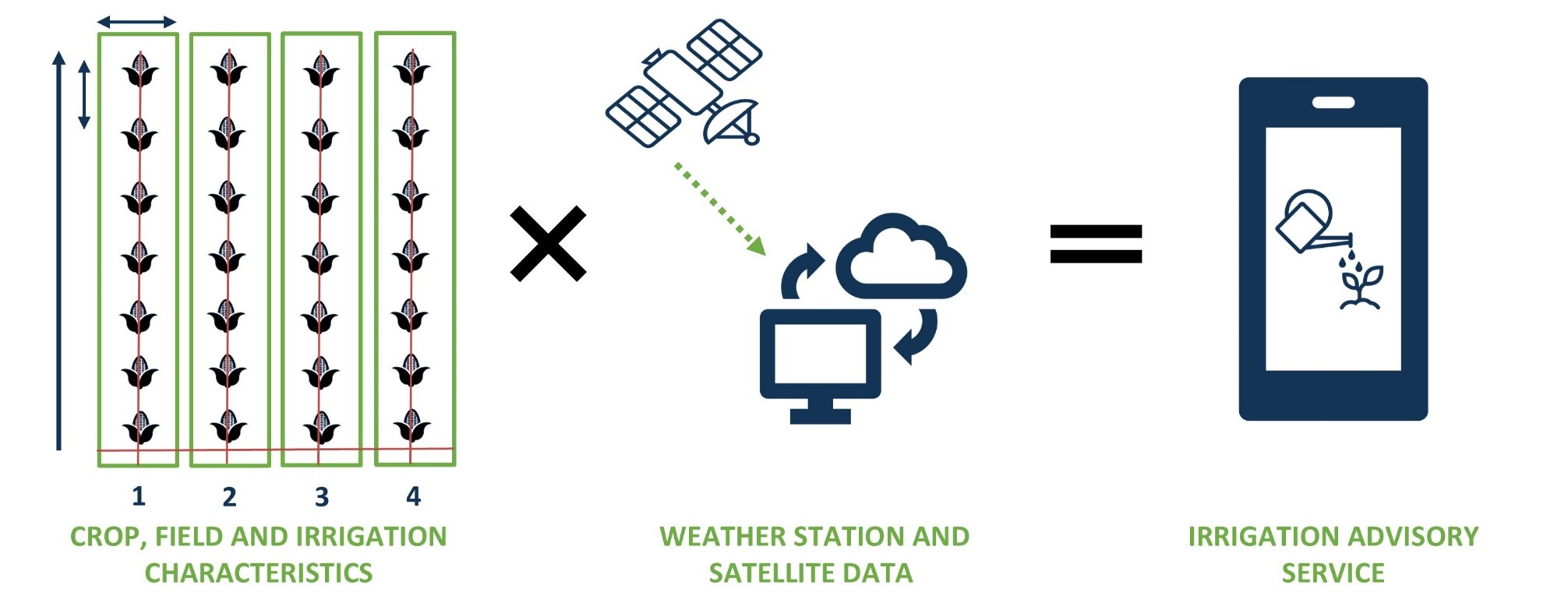
Croptimal combineert gewas-, veld- en irrigatiekenmerken met gegevens van weerstations en satellieten om irrigatieadvies te leveren.

Het project behelst de haalbaarheid van een goedkoop, geïntegreerd irrigatiesysteem “Smart Sprayer”, gebaseerd op Croptimal maar aangepast aan landbouw op hellingen, dat praktisch irrigatieadvies geeft via WhatsApp/SMS. De belangrijkste innovatie is de Smart Sprayer, een door zwaartekracht gevoed micropivot irrigatiesysteem met lage druk dat wordt gecombineerd met een op maat gemaakte slimme irrigatietool. Het digitale platform levert dagelijks gegevensgestuurd irrigatieadvies aan de telefoons van boeren. Samen bieden ze een schaalbaar en kosteneffectief pakket voor nauwkeurig en efficiënt watergebruik op afgelegen boerderijen in heuvels.

Het hoofddoel is het verbeteren van de waterzekerheid en landbouwproductiviteit van kleine boeren in het middengebergte tijdens het droge seizoen in Nepal. Meer specifiek gaat het erom de technische, economische en sociale haalbaarheid aan te tonen van een lagedrukirrigatieoplossing in combinatie met irrigatieadvies op basis van teledetectiedata en weersvoorspellingen. Dit omvat marktonderzoek en de ontwikkeling van business cases voor zowel boeren als lokale leveranciers.

De Croptimal-app is beschikbaar via Croptimal.app. Neem contact met ons op als u meer informatie wilt of een eigen account wilt aanvragen.

Video: Croptimal – Smart Irrigation Advice Powered by Data

Video: Croptimal in Nepal

Video: Resultaten van de haalbaarheidsstudie


De alarmerende afname van bronnen wordt toegeschreven aan de snelle uitbreiding van wegennetwerken, samen met veranderingen in landbedekking en klimaat. Wegenaanleg in deze gebieden stelt bronnen bloot aan verstoringen of verandert hun natuurlijke uitstroom, terwijl rotsafgravingen de locatie van bronopeningen verstoren. Dit probleem is grotendeels onopgemerkt gebleven en vormt een aanzienlijke bedreiging voor de lokale gemeenschappen en hun watervoorraden.

Het overkoepelende doel van het project is om wegen opnieuw te beschouwen als instrumenten voor landschapsverbetering in plaats van als tegenstanders, waarbij wegenaanleg positief bijdraagt aan lokale watervoorraden. Door technieken en hulpmiddelen te integreren (digitale tweelingen en een beslissingsondersteunend instrumentarium), streeft het project ernaar veilige en betrouwbare watervoorziening te waarborgen voor mensen in berggebieden, terwijl de kwaliteit van de weginfrastructuur behouden blijft en de connectiviteit wordt gewaarborgd. De gemeente Dhankuta en het Department of Local Infrastructure (DoLI), dat infrastructuurontwikkelingsactiviteiten in Nepal reguleert, zullen de primaire begunstigden van dit project zijn.

De verwachte resultaten van het RoSPro-project zijn:

  1. Succesvolle implementatie van bescherming van bronnen langs wegen door middel van proefinterventies in de gemeente Dhankuta en het bevorderen van benaderingen zoals “natuurlijke oplossingen” en “Groene Wegen voor Water (GR4W)”.
  2. Generatie van bewijsmateriaal over de impact van de proefinterventie door middel van een kosten-batenanalyse.
  3. Beoordeling van de potentiële impact van het opschalen van bronbescherming langs wegen via de ontwikkeling van een digitale tweeling en een beslissingsondersteunend instrumentarium.
  4. Capaciteitsopbouw voor de gemeente Dhankuta en DoLI met betrekking tot benaderingen, technologieën, impact en opschaling van bronbescherming langs wegen.

RoSPro zal leiden tot verbeterde waterzekerheid voor consumptief en productief gebruik, wat direct tot 500 huishoudens in de regio ten goede zal komen. Na de pilotfase streeft het project ernaar zijn diensten uit te breiden naar bestaande klanten en partnernetwerken in Azië en Afrika. De vraag naar vergelijkbare diensten is hoog in veel hooggebergtegebieden, en RoSPro wil een kader genereren om dit op nationale en regionale schaal op te schalen.

Zo is RoSPro een belangrijke initiatief dat zich richt op het aanpakken van het kritieke probleem van afnemende bronnen in de Himalaya. Door wegenaanleg te transformeren tot een bijdrage aan lokale watervoorraden, zal RoSPro de waterveiligheid en -zekerheid verbeteren, ten goede komen aan zowel de gemeenschappen als het milieu in deze uitdagende bergachtige regio’s.

The inital Climate Risk Assessment (CRA) by FutureWater in 2021 for the Asian Development Bank (ADB) identified the need for a detailed CRA for the DKSHEP to understand the risk posed by the changing climate on hydropower and the environment. Therefore, the objective of this Climate Risk and Adaptation Assessment (CRA) is to assess the vulnerability of the project components to future climate change and recommend adaptation options for climate-proofing the design. This CRA covers both type 2 adaptation, related to system change and resilience building, as well as type 1 adaptation related to climate-proofing. FutureWater will support ADB to ensure that the project will adequately address climate change mitigation and adaptation in accordance with ADB’s requirements.

FutureWater will make use of state-of-the-art downscaled Coupled Model Intercomparison Project Phase 6 (CMIP6) ensembles, and other relevant hazards and local information to develop this CRA. Insights from the CRA will be used to devise adaptation strategies. FutureWater will also ensure climate resilience measures are incorporated into the detailed design and environmental management planning before finalizing the climate change risk assessment. Together with the client’s engineering and safeguards team (Nepal Electricity Authority), FutureWater will ensure that the detailed design and environmental management plans incorporate all other recommended climate resilience measures and that their implementation is sufficiently detailed including bioengineering techniques, nature-based solutions, and an early warning system. FutureWater will collate the information and work closely with the national geological and GLOF consultants to review all available options for (i) sediment management plan, (ii) upstream catchment management plan, and (iii) emergency preparedness and response plan. FutureWater will provide several capacity-building sessions to the project team on the findings of the initial CRA, and the potential options for climate resilience measures to incorporate in the project design and operation to address the risks identified. Moreover, this project will develop a GHG account and prepare SARD climate change screening and Paris Agreement alignment assessment.

The Asian Development Bank (ADB) identified the need for a detailed Climate Risk and Adaptation (CRA) assessment for the DKSHEP to understand the risk posed by the changing climate on hydropower and the environment. Therefore, the objective of this Climate Risk and Adaptation Assessment (CRA) is to assess the vulnerability of the project components to future climate change and recommend adaptation options for climate-proofing of the design. Therefore, this CRA covers both type 2 adaptation, related to system change and resilience building, as well as type 1 adaptation related to climate-proofing This CRA assesses historic trends in relevant climate-related variables and analyses climate projections for the DKSHEP. Based on these projections, an assessment of the current and future climate risks and vulnerabilities relating to the proposed project activities will be outlined. Finally, recommendations will be presented for climate adaptation measures.

Nepal’s freshwater availability and timing are under thread by extreme temperature and precipitation variations, changing monsoon patterns, melting of ice caps and glaciers, and reduced snow cover. Some initial estimated economic cost of climate change in agriculture, hydropower and water induced disasters show a number of up to 2-3% of GDP per year by 2050.

The proposed project aims to improve landscape-scale adaptation and disaster risk management through a set of outputs:

  1. Climate-smart landscape management practices adopted and enhanced
  2. Climate-resilient rural livelihoods developed
  3. Integrated disaster risk reduction and climate change adaptation approaches
  4. Capacities of local communities, regional and national decision-makers, and institutions on climate change adaptation and disaster risk reduction strengthened

FutureWater developed a so-called “Problem Tree” analysis for the proposed project. A Problem Tree is a helpful tool to understand the relationships between a problem, its causes, and its effects. The trunk of the tree represents the main problem, the roots the causes of the problem, and the branches the direct and indirect effects of the problem.

The project will be further developed as a so-called Climate Change Adaptation Project. More traditional development projects include also climate proofing, but focus is on development investments and adaptation is a secondary objective. Although those development projects contribute to adaptation (by helping the proposed asset or activity being financed to adapt to identified physical climate risks to the asset/activity), the primary objective of such a project is not adaptation. Climate Change Adaptation Projects are intentionally designed to enable climate adaptation of a high-risk topics. This is achieved by supporting outputs and activities that reduce the impacts of current and future expected climate risks and/or address barriers to adaptation, thereby advancing resilience. So this Climate Change Adaptation Project is meant to advance Nepal’s goal on adaptation.

Flooding has always been a major cause of natural disasters in a mountainous country like Nepal. Among the many natural disasters that affect Nepal, the recurring floods during the monsoon season have catastrophic consequences every year. Nepal’s fragile geological conditions and complex topography combined with frequently occurring extreme rainfall during the monsoon poses risks to communities living along the flood plains. In order to ensure good flood management practices and the development of long-term water management strategies a good understanding of key hydrological processes and the ability to simulate future changes in streamflow is a prerequisite.

During recent years, FutureWater has done many projects in collaboration with NGO’s, INGO’s and academic institutions in Nepal. This is the first time FutureWater collaborated with the Institute of Forestry (IOF), Nepal to provide their teaching faculty and researchers a training on “Use of open source platform for hydrological modelling of data sparse regions in Nepal”. The Tailor Made Training (TMT) was fully funded by NUFFIC’s Orange Knowledge Programme (OKP) and took place from 8 April to 24 April 2019 in Pokhara, Nepal.

Essential skills, in particular modelling of hydrological processes are currently lacking at IOF, hampering the capacity to gain deep understanding of the present and future flood management situation in the region. Therewith IOF faces difficulties in developing long-term strategies to deal with climate change impacts for Nepal’s water resources. Further, the lack of ground-based measurements in the Himalayan region imposes an additional level of complexity while modelling the hydrological characteristics of this region. The use of readily available open source satellite-based data can augment the limited ground-based observation in the region.

Overall, the training fulfilled all the needs of the IOF, and was positively evaluated by the participants. This training program has encouraged the faculty members from IOF to use open source data and platforms in their future research and teaching.

The SREB is part of the Belt and Road Initiative, being a development strategy that focuses on connectivity and cooperation between Eurasian countries. Essentially, the SREB includes countries situated on the original Silk Road through Central Asia, West Asia, the Middle East, and Europe. The initiative calls for the integration of the region into a cohesive economic area through building infrastructure, increasing cultural exchanges, and broadening trade. A major part of the SREB traverses Asia’s high-altitude areas, also referred to as the Third Pole or the Asian Water Tower. In the light of the planned development for the SREB traversing the Third Pole and its immediate surroundings, the “Pan-Third Pole Environment study for a Green Silk Road (Pan-TPE)” program will be implemented.

The project will assess the state and fate of water resources in the region under following research themes:

1. Observed and projected Pan-TPE climate change
2. Impacts on the present and future Water Tower of Asia
3. The Green Silk Road and changes in water demand
4. Adaptation for green development

In irrigated agriculture options to save water tend to focus on improved irrigation techniques such as drip and sprinkler irrigation. These irrigation techniques are promoted as legitimate means of increasing water efficiency and “saving water” for other uses (such as domestic use and the environment). However, a growing body of evidence, including a key report by FAO (Perry and Steduto, 2017) shows that in most cases, water “savings” at field scale translate into an increase in water consumption at system and basin scale. Yet despite the growing and irrefutable body of evidence, false “water savings” technologies continue to be promoted, subsidized and implemented as a solution to water scarcity in agriculture.

The goal is to stop false “water savings” technologies to be promoted, subsidized and implemented. To achieve this, it is important to quantify the hydrologic impacts of any new investment or policy in the water sector. Normally, irrigation engineers and planners are trained to look at field scale efficiencies or irrigation system efficiencies at the most. Also, many of the tools used by irrigation engineers are field scale oriented (e.g. FAO AquaCrop model). The serious consequences of these actions are to worsen water scarcity, increase vulnerability to drought, and threaten food security.

There is an urgent need to develop simple and pragmatic tools that can evaluate the impact of field scale crop-water interventions at larger scales (e.g. irrigation systems and basins). Although basin scale hydrological models exist, many of these are either overly complex and unable to be used by practitioners, or not specifically designed for the upscaling from field interventions to basin scale impacts. Moreover, achieving results from the widely-used FAO models such as AquaCrop into a basin-wide impact model is time-consuming, complex and expensive. Therefore, FutureWater is developing a simple but robust tool to enhance usability and reach, transparency, transferability in data input and output. The tool is based on proven concepts of water productivity, water accounting and the appropriate water terminology, as promoted by FAO globally (FAO, 2013). Hence, the water use is separated in consumptive use, non-consumptive use, and change in storage (see Figure).

Separation of water use according to the FAO terminology.

A complete training package is developed which includes a training manual and an inventory of possible field level interventions. The training manual includes the following aspects: 1) introduce and present the real water savings tool, 2) Describe the theory underlying the tool and demonstrating some typical applications, 3) Learn how-to prepare the data required for the tool for your own area of interest, 4) Learn when real water savings occur at system and basin scale with field interventions.

The REWAS tool can be downloaded here.