The MRC’s State of the Basin Report (SOBR) is a flagship product of the organization and an integral part of the MRC’s strategic planning cycle. Compiled about every five years based on the available data and information, the report assesses conditions and trends within the basin and the impacts that development and use of water and related natural resources are having. The SOBR provides a statement of past trends and current conditions, and seeks to highlight and provide guidance to Member Countries on significant transboundary issues that require cooperation among basin countries to address. The SOBR 2023 is structured around the Mekong River Basin Indicator Framework, consisting of 5 dimensions: Environment, Social, Economic, Climate Change, and Cooperation.
As a longstanding collaborator of MRCS, FutureWater was engaged to support the development of the Economic and Climate Change chapters of the SOBR 2023 and perform the related activities of data analyses, advisory on data gaps and SOBR content, attractive presentation of key results, and communication with Member Countries and specialized MRCS staff to address their comments and suggestions.
The Mekong State Of the Basin Report (SOBR) is published by the Mekong River Commission (MRC) every five years, in advance of the cyclic updating of the Basin Development Strategy. The SOBR plays a key role in improving monitoring and communication of conditions in the Mekong Basin, and is MRC’s flagship knowledge and impact monitoring product. It provides information on the status and trends of water and related resources in the Mekong Basin. The 2023 SOBR is based on the MRC Indicator Framework of strategic and assessment indicators and supporting monitoring parameters, which facilitates tracking and analysis of economic, social, environmental, climate change and cooperation trends in the basin.
FutureWater was hired by MRC to perform the following tasks in support of the 2023 SOBR development:
Data collection on the Extent of Salinity intrusion in the Mekong Delta and the conditions of the Mekong River’s riverine, estuarine, and coastal habitats
Analyses of the extents of 2010, 2015, and 2020 LMB wetlands
Analyses of the extents of key fisheries habitat areas in the LMB, and
Data collection for all Assessment Indicators of MRB-IF for the Upper Mekong River Basin (UMB), including reporting and extracting key messages
Implementation of tasks 1 – 3 is achieved by using state-of-the-art remote sensing tools, such as the Google Earth Engine, building on the methods developed in the preceding project.
Task 4 builds on the findings of FutureWater’s contribution to the 2018 SOBR regarding the status of the UMB in China and Myanmar, more details can be found here.
Sustainable Development Goal (SDG) 6 seeks to ensure access to clean water and sanitation for all, focusing on the sustainable management of water resources, wastewater and ecosystems. The targets associated with SDG 6 are to be achieved by monitoring and improvement of several indicators. Assessment of these indicators requires a considerable amount of data, which are in many countries not readily available. Also in Myanmar, challenges are posed to the national statistical system to collect, manage and report the necessary input data. As the Myanmar branch of the lead UN development agency, UNDP Myanmar carries out activities to support implementation of the SDGs. Acknowledging the recent political developments in Myanmar, more than ever it is important to explore innovative sources of data to support monitoring and evaluation of progress towards the SDGs. FutureWater was contracted to produce an issue brief which explores the availability of geospatial data, in particular derived from Earth Observation (EO) from satellites, to monitor 4 water-related SDG indicators.
The Directorate of Water Resources and Improvement of River Systems (DWIR) is one of the key government agencies in the field of integrated water resources management in Myanmar. DWIR consists, next to its national head offices, of twelve regional offices. Regional DWIR offices concentrate on flood protection by maintenance of the river and its embankments.
National-level DWIR staff attended previous trainings on Google Earth Engine (GEE) organized by FutureWater and HKV in Myanmar, during which GEE was identified as a particularly relevant tool to support DWIR’s mission. FutureWater and HKV have also successfully collaborated in a Partners for Water project focusing on operational rainfall monitoring. In particular, regional-level DWIR staff can benefit from using GEE for successfully complying with their mandate concerning design and practical implementation of riverbank and flood protection measures. They need to work with geospatial data on historical river morphology, flood extent, as well as hydrological baseline data on e.g. rainfall and evapotranspiration. With the overall capacity of the regional-level staff somewhat lower than the national level staff, this TMT aims to achieve a great leap forward by acquainting regional staff with geodata access, analyses and interpretation using GEE, to benefit the quality of flood protection measures and overall water safety in Myanmar.
The training is implemented by a mix of Dutch and Burmese trainers, who provide a program consisting of a month on-distance support, a two-and-a-halve-week in-country training followed by a period of 6 months of regular on-distance support. Following the COVID-19 pandemic, in-country training components are converted to an eLearning approach.
The Inle Lake in Myanmar is renowned for a number of traditional cultural and livelihood practices, which have made it one of the main attractions for Myanmar’s booming tourism industry. The lake is, however, suffering environmental degradation from the combined effects of unsustainable resource use, increasing population pressures, climate variability and rapid tourism development. UNDP is supporting the establishment of ILMA, which will have the mandate to manage conservation activities in the Inle Lake protected area.
Under this project, a set of maps will be developed and delivered to the ILMA geodatabase. Different methods, including satellite remote sensing and GIS, will be integrated to complete an updated boundary demarcation of the protected area, based on the Inle Lake watershed boundaries and recent developments in land use. Key ecosystem services of Inle Lake region will be mapped, which will inform an updated zoning (core zone, buffer zone, transition zone) of Inle Lake protected area. Workshops and bilateral meetings are organized to consult with the government stakeholders at several steps during the project, and a training workshop on ecosystem services mapping will be organized at the end of the project.
Myanmar is a country with huge water and agriculture-related challenges. However, ground data on e.g. river flows, rainfall and crop growth are only very sparsely available. This training supported by Nuffic aimed to build capacity across the water sector in Myanmar in overcoming these limitations by using Google Earth Engine, a state-of-the art tool for accessing and processing a wealth of geographical datasets. Participants from academia, higher education, and govenment agencies, attended two training sessions hosted by YTU (the main requesting organization) and implemented by FutureWater and HKV. During the intermediate period, remote support was offered to the participants via Skype, email and the dedicated Facebook page. Results of the individual assignments, which were formulated by the participants based on their personal objectives, were presented in a final symposium.
Higher educational staff was trained to achieve sustainable impact by implementing Google Earth Engine in their curricula and train a new generation of modern and well-equipped water professionals. Public sector representatives participated to obtain skills that can be directly and sustainably implemented in their respective organizations, to benefit effective and equitable water management.
The SREB is part of the Belt and Road Initiative, being a development strategy that focuses on connectivity and cooperation between Eurasian countries. Essentially, the SREB includes countries situated on the original Silk Road through Central Asia, West Asia, the Middle East, and Europe. The initiative calls for the integration of the region into a cohesive economic area through building infrastructure, increasing cultural exchanges, and broadening trade. A major part of the SREB traverses Asia’s high-altitude areas, also referred to as the Third Pole or the Asian Water Tower. In the light of the planned development for the SREB traversing the Third Pole and its immediate surroundings, the “Pan-Third Pole Environment study for a Green Silk Road (Pan-TPE)” program will be implemented.
The project will assess the state and fate of water resources in the region under following research themes:
1. Observed and projected Pan-TPE climate change
2. Impacts on the present and future Water Tower of Asia
3. The Green Silk Road and changes in water demand
4. Adaptation for green development
The Mekong State Of the Basin Report (SOBR) is published by the Mekong River Commission (MRC) every five years, in advance of the cyclic updating of the Basin Development Strategy. The SOBR plays a key role in improving monitoring and communication of conditions in the Mekong Basin, and is MRC’s flagship knowledge and impact monitoring product. It provides information on the status and trends of water and related resources in the Mekong Basin.
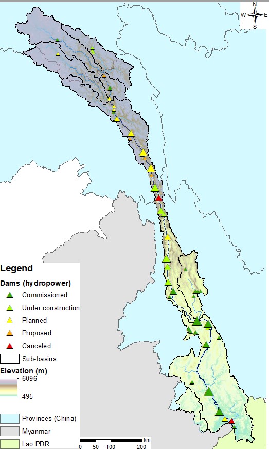
The Upper Mekong Basin in China and Myanmar
The 2018 SOBR is based on the MRC Indicator Framework of strategic and assessment indicators and supporting monitoring parameters, which facilitates tracking and analysis of economic, social, environmental, climate change and cooperation trends in the basin. Compared to earlier editions, the geographical scope of the 2018 Mekong SOBR is extended to include the Upper Mekong (“Lancang” in China) Basin. FutureWater was contracted to draft the dedicated chapters on the Myanmar and China parts of the basin.
The Upper Mekong Basin has seen rapid economic development, radical land use changes and extensive hydropower development on the mainstream. From its satellite office in Vientiane, FutureWater is currently evaluating the hydrological, environmental, economic and social status and trends of the Upper Mekong Basin. This involves elaborate consultation of a variety of information sources, including remote sensing data, public domain GIS datasets, meetings with regional experts, and review of scientific literature and technical reports. A first draft of both chapters will be completed by the end of June 2018, which will be sent to MRC member countries and dialogue partners for review. The final version of the Mekong SOBR is foreseen to be the published at the end of the year.
Cover picture: Miaowei Dam on the Upper Mekong in China (credit: CGIAR WLE Greater Mekong).
Significant decisions are to be made to manage and engineer the water systems in Myanmar and to develop large structural and non-structural projects (e.g. hydropower dams, urban water use, industrial development, extension of irrigation capacity, operational quantity and quality management, etc.). Global experience shows that such activities can have irreversible consequences and impose significant costs to economies, cultures and the environment. Early integration of inclusive management strategies can prevent future problems. This is recognized in Myanmar. The Myanmar and Dutch governments have agreed to cooperate on Integrated Water Resources Management (IWRM) through a Memorandum of Understanding (MoU) between the Myanmar Ministry of Transport and Dutch Ministry of Infrastructure and the Environment. To build on the activities that have been performed under this MoU, the project “Leapfrogging Delta Management in Myanmar” was initiated by TU Delft, FutureWater and HKV Consultants, and funded under the Partners for Water program.
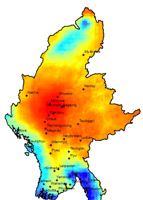
Precipitation in Myanmar
Most monitoring and all operations in Myanmar are currently not near-real time. In the Ayeyarwady Delta some real-time data collection stations for water level, rainfall and water salinity measurements have been installed. Yet most data, such as rainfall and water levels, are collected on paper and sent to central offices by post, which can take 2 months. There are also data gaps in the monitoring network, automatic collection of data can diminish the data gaps. Surface water quality is measured only twice a year. Stage-discharge curves once every five years, which is insufficient as the Myanmar rivers are changing rapidly, leading to inaccurate discharge data. Besides monitoring, the big challenge in Myanmar is to convert raw data into useful information for (end) users. Dutch companies have developed tools and assimilation schemes to combine data and convert it into useful and understandable information for different types of clients and users.
In response to the request of the NWRC in Myanmar and the interest of Dutch innovative enterprises, the project’s main aim is to extend the current work in the Bago-Sittaung to the whole Ayeyarwady Delta in accordance with the agreement between the Myanmar and Dutch governments. The aim is to test and demonstrate innovative smart information solutions in the Delta and disseminate the results widely. Coalitions are created around specific information products (e.g. rainfall, erosion, subsidence). In each coalition, partners work on innovative monitoring: to combine remote sensing, ground data collection with modelling techniques. Opportunities and limitations are discussed with Myanmar professionals. In phase two of the project these innovations are tested, both in the field as well in a data platform environment. Innovative technologies and methods will be adjusted according to local circumstances and requirements in consultation with Myanmar. The successful proven innovations are demonstrated during two demonstration weeks in phase three, in which the entrepreneurs explain the products and the results of the testing to the Myanmar stakeholder and (end) users and to the international donors active in this field in Myanmar.
The results of the project will be presented in an online platform based on HKV Dashboard technology, to disseminate the products and services to a local and international audience. Throughout the entire project Dutch and Myanmar experts and young professionals will work together (learning-by-doing) and dissemination and training will be organized. This will facilitate easy adaptation and implementation of the innovations within the Myanmar government.
Based on its experience in operational rainfall monitoring and downscaling to high resolutions using satellite-derived information, FutureWater is developing the first near-real-time spatial rainfall product for Myanmar. The global algorithms will be tailor-made to the Myanmar situation. The first results come available through the online platform over the course of 2017.