De mediterrane regio staat voor groeiende uitdagingen om de voedsel- en watervoorziening te waarborgen, aangezien landen te maken krijgen met een toenemende vraag en een afnemende beschikbaarheid van natuurlijke hulpbronnen. De nexus-benadering is gericht op het beheren en benutten van synergieën tussen sectoren door middel van efficiënt en geïntegreerd beheer van de Water-, Energie-, Voedsel- en Ecosystemen-nexus (WEFE).
De doelstellingen van BONEX zijn het bieden van praktische en aangepaste hulpmiddelen, het onderzoeken van concrete en contextspecifieke technologische innovaties, het verbeteren van beleid en governance en het vergemakkelijken van de praktische implementatie van de WEFE-nexus, waarbij sociale, economische en ecologische afwegingen in balans worden gebracht.
Het project heeft als doel een nieuw, transdisciplinair diagnostisch WEFE-bridging framework te ontwikkelen, dat methoden op een contextspecifieke manier combineert en verder gaat dan disciplinaire silo’s. De diagnostische hulpmiddelen ter ondersteuning van dit framework zullen worden ontwikkeld en getest in zeven geselecteerde demonstratieprojecten in de regio, waarin innovatieve technologieën worden gepilot (zoals agrivoltaïsche systemen en systemen voor hergebruik van afvalwater).
Als resultaat zal BONEX beleidsmakers en praktijkmensen voorzien van een interactief besluitvormingsinstrument om afwegingen, synergieën en nexus-oplossingsbenaderingen op een transdisciplinaire manier te evalueren. Bovendien zal het waardevolle ervaringen opleveren met het op maat maken van innovatieve WEFE-nexus technologieën, wat nieuwe zakelijke kansen biedt. De WEFE-nexusbenadering is noodzakelijk om duurzame agrovoedselsystemen te implementeren en ecosystemen te behouden.
Binnen BONEX zal FutureWater actief bijdragen aan het pakket van diagnostische hulpmiddelen. Een eenvoudige waterboekhoudtool (REWAS) zal worden gebruikt om te evalueren of met innovatieve technologieën ‘echte waterbesparingen’ worden gerealiseerd. De waterboekhoudtool evalueert waterstromen op veldniveau en op schaal van irrigatiedistricten en bepaalt of er daadwerkelijk ‘echte besparingen’ worden behaald. De tool houdt ook rekening met voedselproductie (opbrengst van gewassen) en zal componenten introduceren voor het evalueren van energie- en waterkwaliteitsaspecten om de WEFE-nexusaspecten aan te vullen. De zeven demonstratieprojecten zullen worden gebruikt om deze waterboekhoudtool te demonstreren en iteratief te ontwikkelen. Een hydrologische analyse zal worden uitgevoerd op geselecteerde locaties om ook de impact op stroomgebiedschaal te evalueren. Uiteindelijk zullen de resultaten van deze analyses worden vertaald naar beleidsimplicaties en bijdragen aan de realisatie van de duurzame ontwikkelingsdoelen (SDG’s).
Dit project maakt deel uit van het PRIMA-programma, ondersteund door de Europese Unie.
The study will focus on selection of key traded crops between the EU and Africa and their key producing regions. The tasks will include overall analysis of current practices and the background in the regions, determination of key sensitive parameters in order to select key crops and food products and map hotspot regions. In addition, project team will assess climate risks for these hotspots on key crops and food products and link these risks with the importing countries. Climate risks will be assessed by identifying the multiple climate sensitivities on the food systems in each region, assessing changes predicted by a CMIP6 (latest) climate model ensemble on key agriculture-related climate indices, and analysing impacts on production-related indices, distinguishing between rainfed and irrigated production systems. It will be focused on country specific case studies in each partner country. The impacts of climate change on trade patterns will be evaluated to assess the carbon- and water footprints and virtual water profiles of key traded commodities of these countries. At the end, the project team will focus on policy relevance and assessment of adaptation strategies and identify interventions that will be needed, at which point in the system, and from which sector (or actor) is of interest.
The outcomes of CREATE will be used to increase awareness of the risks that climate change poses to the agro-food trade and the broader economy at large. They can contribute to efforts by the governments (macro-scale), the communities (meso-scale), as well as relevant agricultural producers (micro scale) in the case study countries, by providing essential information for promoting actions towards mitigating the negative consequences of climate change on agro-food trade.
Morocco is a country with extremely arid areas and a complex topography. The majority of climate change related studies predict increases in temperature and generalised decreases in precipitation, however the outputs of these studies are limited in that the resolution of the climate models used is relatively low and therefore often does not pick up variation over areas of complex topography (in which much of the population live). This study therefore helps generate a higher resolution, bias corrected climate dataset. It is also important that trends in precipitation, and more importantly drought, are better understood as Morocco is highly vulnerable to water scarcity. This study therefore focuses on the impacts of climate change on extreme low precipitation, which is directly linked to water shortages and drought events. The study adds valuable new insights to climate change impact analysis in Morocco and is the first to use downscaled climate data to focus on sector wise impact. The data outputs will be located at a number of universities and government ministries in Morocco.
The Sous-Massa basin is located in central Morocco. It represents an arid area that will likely face water resources challenges into the coming decades due to the influence of climate change and socioeconomic development. Indeed, increases in temperatures and decreases in precipitation are anticipated in the Sous-Massa region, alongside more extreme intense precipitation and drought events. It is therefore important the the impacts of climate change on water availability are better constrained to target resilience measures and better prepare for potential future water scarcity.
With the results of this project, IMWI will be able to apply the Water Accounting Plus framework to the Sous-Massa basin, helping to better constrain the likely impacts of climate change on future water availability. This project therefore helps support the targeting and prioritisation of climate resilient interventions which can be taken by the government and other members of the water sector in this area of Morocco.
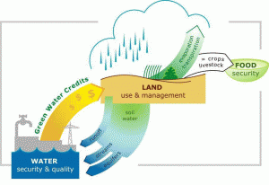
Green Water Credits can be seen as an investment mechanism for upstream farmers to practice soil and water management activities that generate benefits for downstream water users, which are currently unrecognized and unrewarded. This initiative is driven by economic, environmental and social benefits. The implementation of GWC has the potential of enhancing overall water management by reducing damaging runoff, increase groundwater recharge, simulate a more reliable flow regime, and reduce harmful sedimentation of reservoirs.
Green Water Credits: the concept.
The largest issues in the Sebou basin in Morocco are floods, droughts, erosion and the siltation of reservoirs, food and water security, and public health. These issues offer unique opportunities for the implementation of green water management measures. The implementation of these management options can enhance the water availability and reduce problems related to flooding and erosion. However, farmers need incentives to sustainably implement these measures. At the same time, downstream users may be unaware of the benefits they might gain through farmer implementation of these measures in upstream areas. This Proof-of-Concept phase is meant to demonstrate and quantify the potential benefits to all stakeholders in the basin.
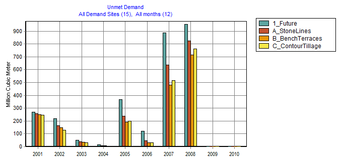
The GWC methodology was applied to the Sebou river basin. Data was gathered, prepared and verified to set up a bio-physical assessment tool (SWAT) to quantify the upstream-downstream interaction in the basin. Three green water management scenarios were analyzed, in order to evaluate the effect of these scenarios on soil evaporation, crop transpiration, surface runoff, sediment inflow into the reservoirs, and groundwater recharge. The GWC scenarios analysed were:
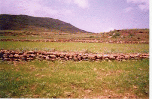
Stone lines (cordons de pierres)
Bench terraces (banquette)
Contour tillage
Green Water Credits measure: stone lines
For the scenarios analyzed, Contour tillage showed the largest decrease in sediment inflow into the reservoirs. The other two scenarios also showed decreases in sediment inflow. Another positive effect is the decrease in surface runoff, and increase in groundwater recharge. The increase in groundwater recharge is especially large for the areas where rainfed broad beans are grown. The increase in groundwater recharge leads to more water inflow into the reservoirs. This increases the water availability for farmers who use the water extensively for irrigation purposes.
By using the SWAT model in combination with WEAP the potential benefits can be assessed. The overall purpose of the WEAP model is to provide a first estimate of the potential impact of the green water management measures. The most effective measures, in terms of benefits only are implementation of bench terraces, followed by carrying out contour tillage, and then constructing stone lines. However, bench terraces are much more expensive than the other two measures, and contour tillage is the most preferable in terms of benefit-cost ratio.
Water shortage (unmet demand) for the future and the three green water management scenarios
The detection of on-site farm reservoirs and ponds in large areas is a complex task that can be addressed through the combination of visual inspection of orthophotos and the application of automatic pixel classification algorithms.
This analysis applied a general workflow to detect and quantify the area and density of on-farm reservoirs and water bodies in three representative Mediterranean irrigated oases in Sicily-Italy, Northern of Morocco, and Israel. For each area of analysis, the most recent orthophotos available were collected from Google Earth, and the ilastik algorithms were implemented for the pixel classification (Random Forest -RF-) and semantic-segmentation. The RF classifier, which is previously applied to a set of filtered imagery and iteratively trained, provides probability maps of different classes that are finally used for quantitative analysis, or the retrieval of a segmentation-categorical (water vs non-water) maps.
SIRRIMED project will address issues related to sustainable use of water in Mediterranean irrigated agricultural systems, with the overall aim of optimizing irrigation water use. The approach proposed in SIRRIMED for reaching this goal will be based in an Integrated Water Irrigation Management (IWIM) where the improved water use efficiency will be considered at farm, irrigation district and watershed scales. These strategies include innovative and more efficient irrigation techniques for improving water productivity and allow savings in water consumption. SIRRIMED will consider the development, test and validation of new deficit irrigation strategies, the sustainable and safe use of poor quality waters and the improvement of precise irrigation scheduling using plant sensors. These new techniques will be integrated with suitable husbandry irrigation practices. At the district scale, efforts should be directed towards an integrated policy of water allocation which accounts for the characteristics and specificity of each farm, requiring the availabity of data bases and efficient management tools (decision support systems) specifically designed to fulfil the objectives of maximizing water use efficiency. At the watershed scale, priority is devoted to the assessment of new models of water governance, and the definition of strategies and policies aimed at promoting a more responsible use of irrigation water. Finally, SIRRIMED will establish a sound dissemination strategy for transfer of knowledge towards the end users, with a real partipatory approach to facilitate an adequate involvement of stakeholders (farmers, association of irrigation users, water authorities and SMEs).
FutureWater has been actively involved in the development of a District Information System (DIS) and a Watershed Information System (WIS) for the Campo de Cartagena case study area.
The proposed DIS will be developed from a GIS-based modelling approach which integrates a generic crop model and a hydraulic model of the transport/distribution system, and will use remote sensing information. The objectives are (i) the development of an operational algorithm to retrieve crop evapotranspiration from remote sensing data, (ii) the development of an information system with friendly user interface for the data base, the crop module and the hydraulic module (WP4 deliverables) and (iii) the analysis and validation of management scenarios from model simulations predicting the respective behaviour of the on-farm and off-farm systems. The overall objective of WP4 is the harmonisation of on-farm and off-farm management by means of a District Information System (DIS) which could be used by stakeholders at purposes of district day-to-day management as well as for planning and strategic decision-making.
The watershed information system (WIS) combines the objectives of acquiring and synthesising the information required for (i) environmental assessment of irrigation activities and (ii) regional planning of water resources, both on catchment scale. In particular, the tool will be designed to supply synthetic and quantitative outputs of the different components of the catchment hydrologic balance, and to diagnose the likely impact of irrigation water use on the quantity and quality of water resources downstream of the irrigation schemes. The development of an information system at the watershed level is a prerequisite for proposing, in the future, strategies of water use and distribution accounting for limited regional water resources and for a limitation of environmental perturbation that can be induced by irrigation activities.
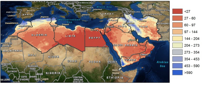
The Middle East and North Africa (MENA) region is considered the most water-scarce region of the world. Disputes over water lead to tension within communities, and unreliable water services are prompting people to migrate in search of better opportunities. Water investments absorb large amounts of public funds, which could often be used more efficiently elsewhere. As the region’s population continues to grow, per capita water availability is set to fall by 50 percent by 2050, and, if climate change affects weather and precipitation patterns as predicted, the MENA region may see more frequent and severe droughts and floods
Map of yearly average precipitation in the MENA region (mm).
The need for alternative and improved water management options is therefore urgently needed, but a clear overview on what the main focus should be is lacking. A broad range of options exists which can be grouped by different approaches such as reducing the demand, increasing the supply, transfer between different sectors, transfer within different sectors, increase storage etc. An important aspect for the MENA region includes desalination.
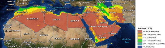
Map of aridity in the MENA region.
To explore different options the World Bank initiated an initiative to generate an improved understanding of water issues in the region and overview of available options under different scenarios of water supply and demand management with special focus on desalination, taking into account the energy nexus and environmental concerns. As part of this initiative, FutureWater will carry out an assessment of water stress in the MENA region, including associated marginal cost of water supply to meet the water supply need. Conducting consultation workshops and meetings will be organized with relevant parties in the region (governmental, universities, civil society groups).
Appropriate planning in water resources, and more specifically in irrigation, is becoming increasingly important given the challenges of already-stressed water resources, climate change, growing population, increase in prosperity, potential food shortages, etc. However, policy makers and planners are often constrained, in this context of increasing complexity, by insufficient knowledge and tools to evaluate the consequences of alternative interventions and thus make the appropriate decisions. Furthermore, important misconceptions often underlie strategies proposed to address these problems.
To illuminate these issues, a scenario-based policy oriented demonstration model is presented here. The term model here refers more to a demonstration tool rather than a software package. The model as developed includes physical processes, but at a lumped and parametric level. Most importantly, the model will focus on scenario and intervention analysis, so that policy makers can better understand and evaluate the impact and interactions of a certain change or decision they plan to make, and the changing environment in which they are operating.
The model is developed in WEAP and is based on water scarce basin. A copy of the WEAP model can be obtained through SEI.