Binnen 3POLE4FOOD draagt FutureWater bij aan de beoordeling van de langetermijngevolgen van klimaatverandering voor de waterbeschikbaarheid en de gewasproductie in belangrijke Aziatische stroomgebieden. Het project combineert modellering van berghydrologie met modellering van stroomafwaartse hydrologie en gewasproductie om beter te begrijpen hoe veranderingen in sneeuw, gletsjersmelt, neerslag en temperatuur de irrigatiewatervoorziening en de landbouwproductie beïnvloeden.
FutureWater leidt belangrijke technische activiteiten met betrekking tot klimaatforcering, biascorrectie van meteorologische datasets en het genereren van klimaatveranderingsscenario’s. Samen met Hydrominds en de Universiteit van Wageningen voeren we glacio-hydrologische modellering uit en analyseren we de waterverbindingen tussen stroomopwaartse en stroomafwaartse gebieden. Met behulp van het SPHY-model worden historische en toekomstige afvoeren uit berggebieden gesimuleerd, inclusief de bijdragen van neerslag, smeltwater uit sneeuw en gletsjers. Deze resultaten worden gekoppeld aan het LPJmL-model om de waterbeschikbaarheid stroomafwaarts, de irrigatiebehoefte, de gewasopbrengsten en de waterproductiviteit van gewassen te beoordelen onder toekomstige klimaat- en sociaal-economische scenario’s.
Het project biedt een wetenschappelijke basis voor het identificeren van risicogebieden en het inzichtelijk maken waar landbouwsystemen kwetsbaarder kunnen worden voor veranderingen in de watervoorziening uit berggebieden. Door klimaat, hydrologie en voedselproductie met elkaar te verbinden, ondersteunt 3POLE4FOOD een op bewijs gebaseerde planning voor veerkrachtige stroomgebieden en duurzame voedselsystemen in Azië.
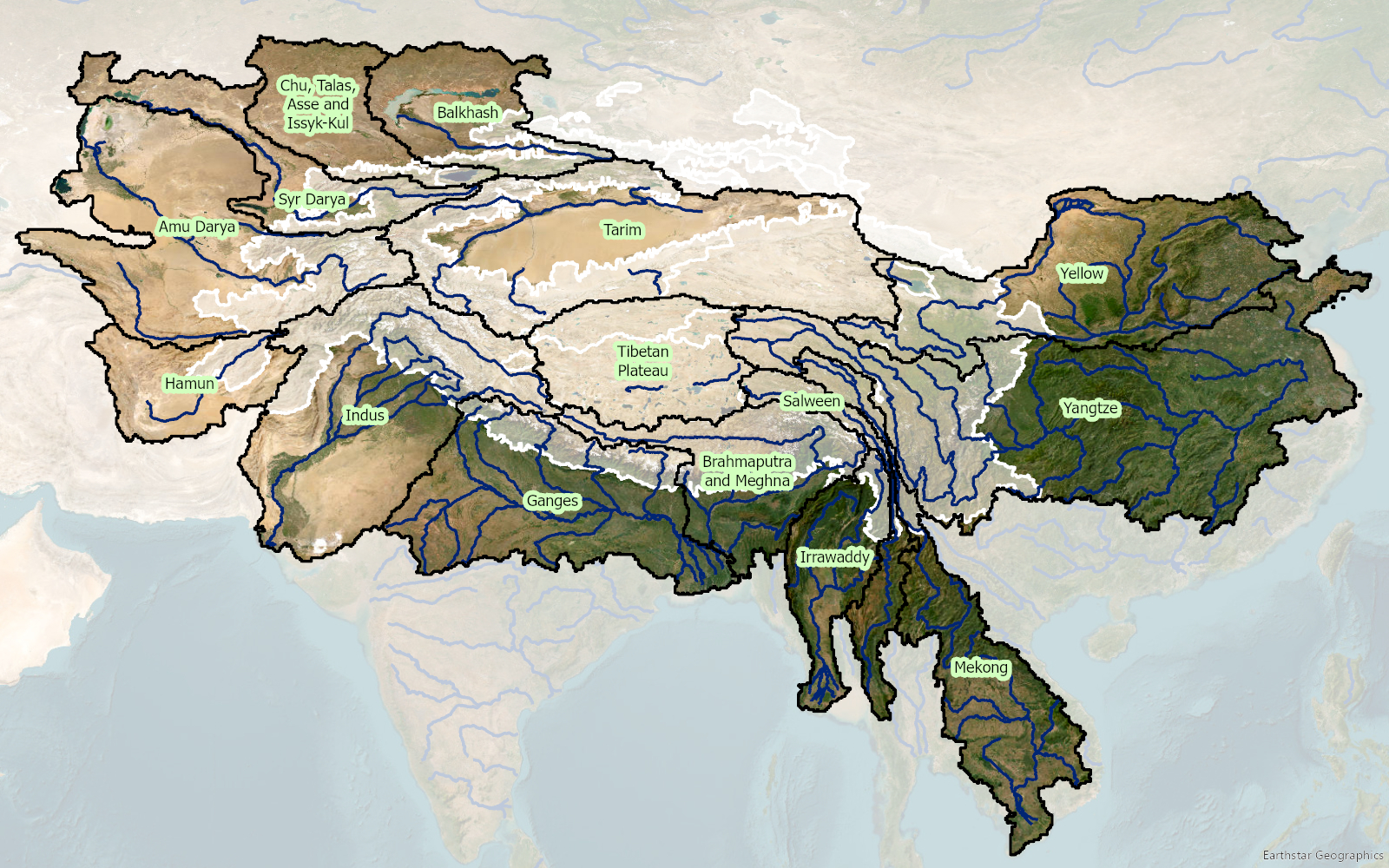
Stroomgebieden die hun oorsprong vinden in de hoge bergen van Azië en die deel uitmaken van het 3POLE4FOOD-project. De witte veelhoek geeft de delen in de hoge bergen aan.
Countries in Asia and the Pacific region are significantly exposed to disaster risks from various hazards and are on the frontline of a climate emergency. Studies suggest that 80% of the globally affected people belong to the Asia-Pacific region, thus emphasizing the critical need for an effective multi-hazard EWS.
EWS, a cost-effective tool for saving lives and reducing economic losses, is particularly crucial for frequent and hazardous weather, water, and climate events. However, despite advancements in the four EWS components, major gaps persist, with implementation lagging and limited coverage in frontline countries, including least developed countries (LDCs) and small island developing states (SIDS). As of 2021, only 50% of countries in Asia and the Pacific reported having multi-hazard early warning systems (MHEWS), emphasizing the need for support.
The culmination of these efforts will be encapsulated in a scoping report, documenting the results of the project, including consultations with key partners and stakeholders during the Regional Workshop on Increasing Investments in Early Warning Systems, to be held in February 2024 in Bangkok, Thailand. The study will offer a comprehensive summary of the EWS scoping, encompassing the policy and institutional landscape, status, initiatives, and investments, as well as residual gaps for regional and national EWS programming in selected DMCs. Additionally, this study will provide guidelines for the implementation and operationalization of the proposed EWS facility, along with initial investment concept notes based on EWS priorities at regional and/or national levels. This holistic approach aims to contribute substantively to the strengthening of EWS capacities, fostering resilience in the face of increasing disaster risks across the region.
To this end, FutureWater, in collaboration with unique land use GmbH and the Central Himalayan Rural Action Group, is conducting a training program on Springshed Management in four states, Uttarakhand, Himachal Pradesh, Madhya Pradesh, and Uttar Pradesh India. The program aims to equip the local stakeholders with practical tools and best practices for managing springshed and springs in the region. The key beneficiaries of these trainings are the forest departments of these four states under the Ministry of Environment, Forestry and Climate Change (MoEF&CC). Funded by GIZ India, these trainings will covers key topics, including:
Concepts of springs and springshed management protocols and best practices
Hydro-geological data collection during a field expedition
Springshed mapping
Connecting forest ecosystem services to water resources
For the first round of training the consortium will start training with the Uttarakhand Forest Department (UKFD) in Dehradun, India. This initiative aims to strengthen sustainable water management practices and safeguard these critical water sources for future generations.
Agriculture is the most water demanding and consuming sector, globally responsible for most of the human induced water withdrawals. This abstraction of water is a critical input for agricultural production and plays an important role in food security as irrigated agriculture represents about 20 percent of the total cultivated land while contributing by 40 percent of the total food produced worldwide.
The FAO Regional Office for Asia and the Pacific (FAO-RAP) is concerned about this increase in water use over the last decades that has led to water scarcity in many countries. This trend will continue as the gap between water demand and supply is projected to widen due to factors such as population growth and economic development, and environmental factors such as land degradation and climate change.
Unfortunately, solutions to overcome the current and future water crisis by looking at the agricultural sector are not simple and have often led to unrealistic expectations. Misconceptions and overly simplistic (and often erroneous) views have been flagged and described over the last recent decades. However, uptake of those new insights by decision makers and the irrigation sector itself has been limited.
The “Follow the Water” project will develop a Guidance Document that summarizes those aspects and, more importantly, quantifies the return flows that occurs in irrigated systems. Those return flows are collected from a wide range of experiments and are collected in a database to be used as reference for new and/or rehabilitation irrigation projects.
The FAO/FutureWater project will also develop a simple-to-use tool to track water in irrigated systems using so-called “virtual tracers”. The tool will respond to the demand for a better understanding the role of reuse of water in irrigated agriculture systems. An extensive training package, based on the Guidance and the Tool, is developed as well.
FAO plays an essential role in backstopping the development of the Guidance and the Tool and promoting. FutureWater takes the lead in development of the Guidance, the Tool and the training package. With this, FAO and FutureWater will contribute to a sustainable future of our water resources.
In irrigated agriculture options to save water tend to focus on improved irrigation techniques such as drip and sprinkler irrigation. These irrigation techniques are promoted as legitimate means of increasing water efficiency and “saving water” for other uses (such as domestic use and the environment). However, a growing body of evidence, including a key report by FAO (Perry and Steduto, 2017) shows that in most cases, water “savings” at field scale translate into an increase in water consumption at system and basin scale. Yet despite the growing and irrefutable body of evidence, false “water savings” technologies continue to be promoted, subsidized and implemented as a solution to water scarcity in agriculture.
The goal is to stop false “water savings” technologies to be promoted, subsidized and implemented. To achieve this, it is important to quantify the hydrologic impacts of any new investment or policy in the water sector. Normally, irrigation engineers and planners are trained to look at field scale efficiencies or irrigation system efficiencies at the most. Also, many of the tools used by irrigation engineers are field scale oriented (e.g. FAO AquaCrop model). The serious consequences of these actions are to worsen water scarcity, increase vulnerability to drought, and threaten food security.
There is an urgent need to develop simple and pragmatic tools that can evaluate the impact of field scale crop-water interventions at larger scales (e.g. irrigation systems and basins). Although basin scale hydrological models exist, many of these are either overly complex and unable to be used by practitioners, or not specifically designed for the upscaling from field interventions to basin scale impacts. Moreover, achieving results from the widely-used FAO models such as AquaCrop into a basin-wide impact model is time-consuming, complex and expensive. Therefore, FutureWater developed a simple but robust tool to enhance usability and reach, transparency, transferability in data input and output. The tool is based on proven concepts of water productivity, water accounting and the appropriate water terminology, as promoted by FAO globally (FAO, 2013). Hence, the water use is separated in consumptive use, non-consumptive use, and change in storage.
A complete training package was developed which includes a training manual and an inventory of possible field level interventions. The training manual includes the following aspects:
Introduce and present the real water savings tool
Describe the theory underlying the tool and demonstrating some typical applications
Learn how-to prepare the data required for the tool for your own area of interest
Learn when real water savings occur at system and basin scale with field interventions
The Swiss Agency for Development and Cooperation’s (SDCs) Global Programme Climate Change and Environment (GP CCE) India is supporting the operationalization of climate change adaptation actions in the mountain states of Uttarakhand, Sikkim and Himachal Pradesh through the phase two of the “Strengthening State Strategies for Climate Action” (3SCA) project that was launched in 2020. The second phase of 3SCA (2020-23), known as the Strengthening Climate Change Adaptation in Himalayas (SCA-Himalayas), while building on the experience and achievements of Phase 1, aims to showcase mountain ecosystem appropriate scalable approaches for climate resilience in water and disaster risk management sectors; using these efforts to enhance the capacities of the institutions across the Indian Himalayan Region (IHR) to plan, implement and mainstream adaptation actions into their programmes and policy frameworks; and disseminating the experiences and lessons at the regional and global level.
Within this programme, SDC has granted a project to FutureWater, together with Utrecht University, The Energy and Resources Institute (TERI), the University of Geneva and a few individual experts. The activities in this project focus on the development and application of climate responsive models and approaches for integrated water resources management (IWRM) for a selected glacier-fed sub-basin system in Uttarakhand and that at the same will find place in relevant policy frameworks paving way for their replication across IHR and other mountainous regions. This will allow the policy makers from the mountain states in India to manage the available water resources in an efficient and effective manner, benefiting the populations depending on these resources.
The combination of future climate change and socio-economic development poses great challenges for water security in areas depending on mountain water (Immerzeel et al., 2019). Climate change affects Asia’s high mountain water supply by its impact on the cryosphere. Changes in glacier ice storage, snow dynamics, evaporation rates lead to changes in runoff composition, overall water availability, seasonal shifts in hydrographs, and increases in extremely high and low flows (Huss and Hock, 2018; Lutz et al., 2014a). On the other and, downstream water demand in South Asia increases rapidly under population growth and increasing welfare boosting the demand for and electricity generation through hydropower. To address and adapt to these challenges integrated water resource management (IWRM) approaches and decision support systems (DSS) tailored to glacier- and snow-fed subbasins are required.
To fulfil the mandate outlined by SDC a framework is presented for IWRM and DSS for Himalayan subbasins consisting of three integrated platforms. (i) A modelling and decision support platform built around a multi-scale modelling framework for glacier and snow fed subbasins, based on state-of-the art and “easy to use” modelling technology. (ii) A stakeholder engagement platform to consult key stakeholders, identify key IWRM issues and co-design a new IWRM plan for Bhagirathi subbasin. (iii) A capacity building platform with on-site training and e-learning modules for the key project components: glacio-hydrological modelling, IWRM and DSS, to ensure the sustainability of the approach and pave the way for upscaling to other subbasins in the Indian Himalayan Region.
The three platforms are designed designed to be flexible, integrated and interactive. Moreover they align with the three outcomes of the project, thus contributing to: develop and validate an integrated climate resilient water resource management approach (Outcome 1); increase technical and institutional capacity in the fields of hydrological modelling, IWRM and DSS (Outcome 2); support the embedding of the IWRM approach tailored to glacier-fed Indian Himalayan subbasins in policies, and provide generic outputs and guidelines to facilitate upscaling to other subbasins in the Indian Himalayan Region (Outcome 3).
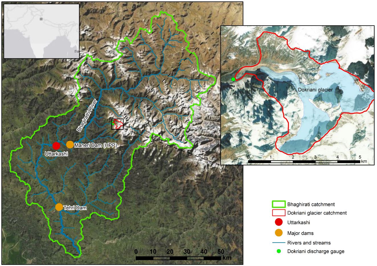
The modelling and decision support platform is designed for operation under the data scarce conditions faced in Himalayan catchments, and yields reliable outputs and projections. The modelling toolset covers the Bhagirathi watershed (Figure below) and consists of 3 hydrological models: (i) a high resolution glacio-hydrological model for the Dokriani glacier catchment (SPHY-Dokriani). Key parameters derived with this model are upscaled to (ii) a distributed glacio-hydrological model that covers the Bhagirathi subbasin (SPHYBhagirathi). Outputs of this model feed into (iii) a water allocation model that overlays the SPHY-Bhagirathi model in the downstream parts of the basin, where water demands are located (WEAP–PODIUMSIM Bhagirathi). This modelling toolset is forced with downscaled climate change projections and socio-economic projections to simulate future changes in water supply and demand in the subbasin. On the basis of stakeholder inputs, adaptation options are identified and implemented in the water allocation model for scenario analysis. Thus, socio-economic projections and adaptation options are co-designed with the stakeholders to ensure maximum applicability, and are tailored to the requirements for formulation of the new IWRM plan. The outputs of the modelling toolset feed into the Decision Support System, where they are presented in such a way that they can truly support decision making in this subbasin. Results of the modelling, decision support and stakeholder engagement platforms jointly support the co-design of an IWRM plan for the subbasin. Capacity in glacio-hydrological modelling, IWRM and the use of DSS is built through a combination of on-site training and e-learning; replicable training modules are developed for glacio-hydrological modelling, IWRM and DSS in general and for this particular approach to support implementation and sustainability.
Overview of the Bhagirathi sub-basin. The inset on the right shows the Dokriani glacier watershed
FutureWater has undertaken a country wide climate risk screening as starting point for further project specific assessments. Main conclusions in the context of the program objectives were that by increased temperatures water supply will be challenged by the risk that water demand will increase and that at the same that supply will reduce by higher evaporation from catchments. Also waste water treatment will face the risk of reduced efficiencies.
India’s number of warm days and nights are expected to increase up to 70%. Water supply, wastewater treatment and urban water bodies will face same challenges as by increased temperature but more intense during those days. Similarly, heat waves are projected to be 3 to 4 times higher by the end of the twenty-first century. The result will be that water supply, waste water treatments and urban water bodies will face same challenges as under increased temperature but even more pronounced during those heat wave periods.
An increase in mean precipitation is uncertain according to various climate projection. If this increase will happen the impact on the three program components (water supply, waste water, urban water bodies) will be manageable. However, a decrease in mean precipitation is projected as well according to some climate scenarios. If this will happen then water supply will be at high risk of water shortages by a higher demand from users and a reduction in supply from rivers, streams and in the longer run from groundwater. An increase in daily precipitation extremes is quite likely to happen according to most climate scenario. Risk of additional flooding will increase.
The analysis concluded that since the location where projects will be implemented in the context of this program has to be defined yet, only generic conclusions relevant for the entire country could be provided. It was highly advised that for each specific project that will be implemented a detailed Climate Risk Assessment has to be undertaken.
The SREB is part of the Belt and Road Initiative, being a development strategy that focuses on connectivity and cooperation between Eurasian countries. Essentially, the SREB includes countries situated on the original Silk Road through Central Asia, West Asia, the Middle East, and Europe. The initiative calls for the integration of the region into a cohesive economic area through building infrastructure, increasing cultural exchanges, and broadening trade. A major part of the SREB traverses Asia’s high-altitude areas, also referred to as the Third Pole or the Asian Water Tower. In the light of the planned development for the SREB traversing the Third Pole and its immediate surroundings, the “Pan-Third Pole Environment study for a Green Silk Road (Pan-TPE)” program will be implemented.
The project will assess the state and fate of water resources in the region under following research themes:
1. Observed and projected Pan-TPE climate change
2. Impacts on the present and future Water Tower of Asia
3. The Green Silk Road and changes in water demand
4. Adaptation for green development
HI-AWARE is one of four consortia of the Collaborative Adaptation Research Initiative in Africa and Asia (CARIAA). HI-AWARE aims to contribute to enhanced adaptive capacities and climate resilience of the poor and vulnerable women, men, and children living in the mountains and flood plains of the Indus, Ganges, and Brahmaputra river basins through the development of robust evidence to inform people-centred and gender-inclusive climate change adaptation policies and practices for improving livelihoods.
HI-AWARE will:
Generate scientific knowledge on the biophysical, socio-economic, gender, and governance conditions and drivers leading to vulnerability to climate change;
Develop robust evidence to improve understanding of the potential of adaptation approaches and practices, with an explicit focus on gender and livelihoods;
Develop stakeholder-driven adaptation pathways based on the up- and out-scaling of institutional and on-the-ground adaptation innovations;
Promote the uptake of knowledge and adaptation practices at various scales by decision-makers and citizens; and
Strengthening the interdisciplinary expertise of researchers, students, and related science-policy-stakeholder networks.
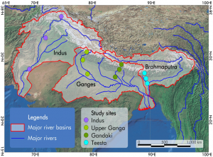
HI-AWARE will focus its activities in 12 sites, representing a range of climates, altitudes, hydro-meteorological conditions, rural-urban continuum, and socio-economic contexts in four study basins: the Indus, Upper Ganga, Gandaki and Teesta. It will conduct research in these sites, including modeling, scoping studies, action research, and randomized control trials. It will test promising adaptation measures in observatory labs at the sites for out-scaling and up-scaling. It will also conduct participatory monitoring and assessment of climate change impacts and adaptation practices to identify:
Critical moments – times of the year when specific climate risks are highest and when specific adaptation interventions are most effective;
Adaptation turning points – adaptation turning points – when current policies and management practices are no longer effective and alternative strategies have to be considered; and
Adaptation pathways – sequences of policy actions that respond to adaptation turning points by addressing both short term responses to climate change and longer term planning.
FutureWater’s main tasks focus on biophysical drivers and conditions leading to vulnerability to climate change. Key tasks are to:
Develop detailed mountain specific and basin scale climate change scenarios;
Improve cryosphere-hydrological modeling to assess significant shifts in flow regimes with an aim to develop water demand and supply scenarios as well as improve and apply water-food impact models; and
Better understand climate change impacts on extremes (heat, floods, drought),and quantify these extremes from climate models and subsequently impact models.
Water is becoming an increasingly critical factor in Asia. The catchments of Hindu – Kush Himalayan (HKH) are a source of a significant portion of this water. Glaciers are a component of the HKH water budget. There is general agreement that a widespread retreat of the global ice cover has been occurring since at least the late 1800s. However, a consensus view of the significance of this retreat in terms of factors determining glacier mass balance, or the resulting water resources and general environmental impacts has not been reached for the HKH mountains. It is believed that only a combined effort of local observation, remote sensing and simulation modeling can lead to a better understanding of what’s happening. Especially the modeling is essential to provide projections for the future.
FutureWater has conducted a review of current state of knowledge in (i) climate change datasets and downscaling used for glacier and high mountain modelling, (ii) glacier and snow contribution to river runoff in the HKH region, (iii) hydrological modelling studies used for glacier and high mountain environments and, (iv) downstream impacts of climate change on the HKH region.
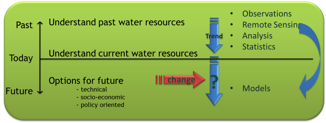
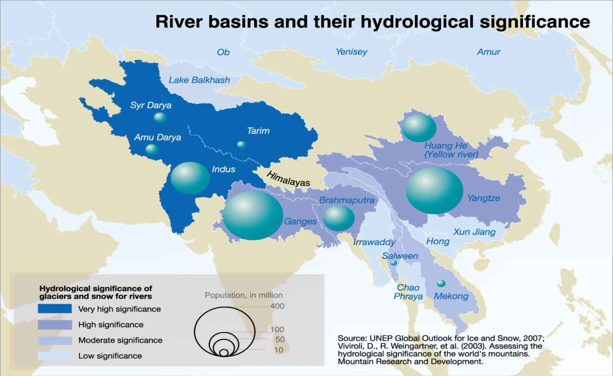
The concept of using simulation models in scenario analysis.Importance of Himalayan’s rivers for people.

 HI-AWARE is one of four consortia of the Collaborative Adaptation Research Initiative in Africa and Asia (CARIAA). HI-AWARE aims to contribute to enhanced adaptive capacities and climate resilience of the poor and vulnerable women, men, and children living in the mountains and flood plains of the Indus, Ganges, and Brahmaputra river basins through the development of robust evidence to inform people-centred and gender-inclusive climate change adaptation policies and practices for improving livelihoods.