Het doel is om de interne modelleringscapaciteit van het IoE op het gebied van klimaatrisico’s en geologische gevaren in Abchazië — met name de kans op modderstromen en aardverschuivingen — te versterken door gerichte online trainingen te ontwikkelen en te verzorgen en door vervolgbegeleiding te bieden, zodat het instituut deze modelleringsmethoden zelfstandig kan toepassen bij zijn overstromingsrisicobeoordelingen en plannen voor risicobeperking.
Het project levert een volledig, besluitvormingsklaar referentiekader voor klimaatrisico’s op voor elk van de tien provincies van Georgië (de negen mkhare plus de Autonome Republiek Adzjarië). Concreet houdt dit in dat het (i) een consistent signaal van klimaattrends samenstelt op basis van acht indicatoren per provincie in het kader van het CMIP6-scenario met hoge uitstoot, (ii) zet gerasterde gevarendatasets en wereldwijde databases met gevarenbeoordelingen om in een vergelijkbare schaal van ‘Laag’ tot ‘Ernstig’ voor zes gevaren per provincie over drie tijdshorizonten (huidige situatie, 2050, 2090), en (iii) verpakt deze in A4-posters die klaar zijn voor opname in de rapportage van ADB-programma’s en provinciale ontwerpworkshops.
FutureWater heeft een reproduceerbare pijplijn gebouwd die drie lagen van bewijs samenbrengt: langetermijnklimaatprognoses, gerasterde gevarengegevens en actuele gevarenbeoordelingen, aangevuld met voor Georgië afgestemde zeespiegelstijging voor de kustprovincies. Een hybride ernststrategie selecteert de meest verdedigbare bron per risico, waarbij gebruik wordt gemaakt van rastergegevens waar deze beschikbaar zijn en door experts gekalibreerde opwaartse regels voor toekomstige klimaatindicatoren waar deze niet beschikbaar zijn. De output voor elke provincie is een enkel profiel van één pagina waarin kaarten, trendgrafieken van indicatoren en risicomatrices over drie tijdshorizonten worden gecombineerd.
Met deze profielen zullen de ADB en de tegenhangers van de Georgische overheid in de watersector in staat zijn om prioriteit te geven aan klimaatadaptatiemaatregelen op nederzettingsniveau in alle tien provincies op basis van een gedeelde, citeerbare bewijsbasis, keuzes voor infrastructuurontwerp te verdedigen op basis van een transparante ernstbeoordeling, en het proces opnieuw uit te voeren naarmate bijgewerkte klimaatprognoses en verbeterde rastergegevens over gevaren beschikbaar komen. Dezelfde aanpak kan worden hergebruikt als sjabloon voor klimaatscreening op nederzettingsniveau elders in de regionale waterportefeuille van de ADB.
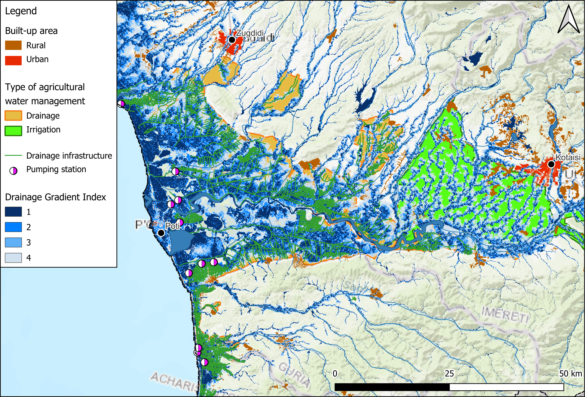
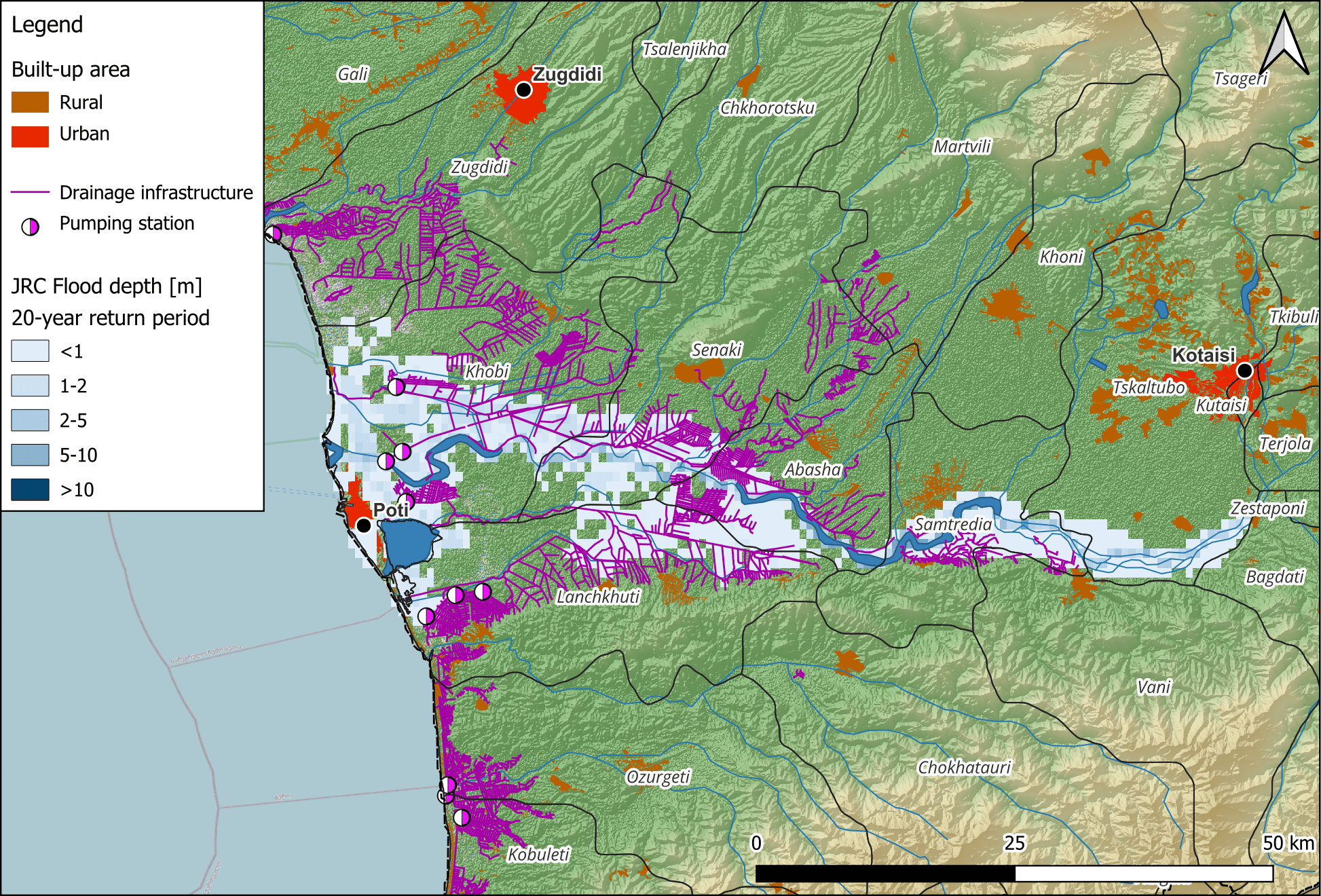
Klimaatverandering zal naar verwachting extreme regenval verergeren, waardoor de verouderde afvoersystemen nog meer onder druk komen te staan en het overstromingsrisico toeneemt. Daarnaast bemoeilijken institutionele en juridische uitdagingen een effectief afwateringsbeheer, waaronder versnipperde verantwoordelijkheden en financieringsbeperkingen. Milieuoverwegingen zijn ook van cruciaal belang, aangezien veel afwateringsgebieden grenzen aan kwetsbare ecosystemen, waaronder het Kolkheti National Park en de Colchic Rainforests and Wetlands, die op de Werelderfgoedlijst van UNESCO staan.
Deze beoordeling zal zich richten op het evalueren van de staat en prestaties van de huidige afwateringssystemen in West-Georgië, het potentieel en de haalbaarheid van hun herstel, het analyseren van het landbouwpotentieel van hersteld land, het beoordelen van de gevolgen voor het klimaat en het milieu en het identificeren van juridische en institutionele hiaten. De bevindingen zullen worden gebruikt voor een haalbaarheidsstudie met strategische aanbevelingen voor het herstel en de modernisering van de drainagesystemen om de landbouwproductiviteit, klimaatbestendigheid en ecologische duurzaamheid in West-Georgië te verbeteren.
The project prepares robust climate mitigation and adaptation pipelines aligned with the Paris Agreement and responsive to DMCs climate change priorities. The TA will support interventions on departmental, sectoral and country levels with key activities including development of a regional strategy, upstream climate assessments, climate pipeline development, government dialogues and capacity building. As part of this project, FutureWater conducts a regional climate risk assessment for ten countries. This includes an assessment of baseline and future climate hazards, exposure and vulnerability and addressing sectoral impacts and adaptation options for a wide range of sectors. In addition country profiles summarizing climate risks for the ten countries are generated. The reginal climate risk assessment feeds into the climate strategy.
The objective of the study is to develop a high-level climate change assessment for Georgia with a focus on water resources and the agricultural sector. The work includes an assessment of climate-related impacts on water resources, identification of priorities at a national level, and preparation of a list of climate investment priorities based on climate analytics and appropriate tools and models and prior work done in the region. The output of the study will contribute to the proposed roadmap for the CAREC Water Pillar and will feed into the ongoing formulation of the Country Partnership Strategies for Georgia. The acquired results will inform follow-up work on the CAREC Water Pillar and provide input to future ADB programming and investment in the agriculture, natural resources, and rural development (ANR) sector.
The project consists of two major outputs:
- Output 1: Estimation of future water resources for Georgia up to 2050
A quantitative and qualitative assessment will be undertaken using a combination of primary and secondary data and analytics. The combination of data sources will define the current state of water resources and future water demands, considering population growth and changes in sectoral demand. - Output 2: Identification of opportunities for water resources development
Opportunities for water resources development will be identified based on output 1, stakeholder consultations, the mapping of activities of other development partners, and desk-based literature review.
This glacio-hydrological assessment delivered river flow estimates for three intake locations of hydropower plants in Nakra, Georgia. The assessment included the calibration of a hydrological model, daily river discharge simulation for an extended period of record (1980-2015), and the derived flow duration curves and statistics to evaluate the flow operation of hydropower turbines. The daily flow calculations for the three sites (HPP1, HPP2 and HPP3) can be used in the hydropower calculations, and to assess the overall profitability of the planned investment, considering energy prices, demand, etc.
In the Nakra basin, glacier and snow model parameters were tuned to obtain accurate river flow predictions. Also, the latest technology of remote sensing data on precipitation and temperature (product ERA5) was used to reduce potential errors in flow estimates. Even though these flow estimates are useful for short-medium term evaluations on profitability of the planned investment, climate change pose a challenge for long-term evaluations. Glacier-fed and snow-fed systems, such as the Nakra basin, are driven by a complex combination of temperature and precipitation. Due to future increasing temperature, and changing rainfall patterns, glacier and snow cover dynamics change under climate warming. This can lead to shifts in the flows, like a reduction in lowest flows, and higher discharge peaks when the hydrological system shifts towards a more rainfall-runoff influenced system (Lutz et al. 2016). This can jeopardize the sustainability of the project on the long-term. To provide a better understanding of future river flows, it is recommended to develop a climate change impact assessment.
This hydrological assessment delivered river flow estimates for an intake location of a potential hydropower plant in the Lukhra river, Georgia. The assessment included a tuning of a hydrological model based on knowledge of neighboring basins, daily river discharge simulation for an extended period of record (1989-2019), and the derived flow duration curves and statistics to evaluate the flow operation of hydropower turbines. The daily flow calculations for the site can be used in the hydropower calculations, and to assess the overall profitability of the planned investment, considering energy prices, demand, etc.
In the Lukhra basin, snow model parameters were tuned to obtain accurate river flow predictions. Also, the latest technology of remote sensing data on precipitation and temperature (product ERA5-Land) was used to reduce potential errors in flow estimates. Even though these flow estimates are useful for short-medium term evaluations on profitability of the planned investment, climate change pose a challenge for long-term evaluations. Snow-fed systems, such as the Lukhra basin, are driven by a complex combination of temperature and precipitation. Due to future increasing temperature, and changing rainfall patterns, snow cover dynamics change under climate warming. This can lead to shifts in the flows, like a reduction in lowest flows, and higher discharge peaks when the hydrological system shifts towards a more rainfall-runoff influenced system (Lutz et al. 2016). This can jeopardize the sustainability of the project on the long-term. To provide a better understanding of future river flows, it is recommended to develop a climate change impact assessment.
The Paris Agreement requests each country to outline and communicate their post-2020 climate actions, known as their NDCs. These embody efforts by each country to reduce national emissions and adapt to the impacts of climate change. As ratifying parties, Armenia, Georgia and Uzbekistan must therefore outline how they intend to implement their NDCs and provide information on what the focus of this spending will be. To support this effort, the Asian Development Bank (ADB) is implementing a knowledge and support technical assistance cluster which will help enhance capacities of developing member countries (DMCs) in meeting their climate objectives by assisting in refining and translating nationally determined contributions (NDCs) into climate investment plans.
In this work package, ADB aims to support Georgia, Armenia, and Uzbekistan with the implementation of their NDCs through developing urban climate assessments (UCAs) and mainstreaming low carbon and climate resilience measures into urban planning processes. FutureWater contributed to this effort by supporting knowledge creation in relation to climate change and adaptation which will help each country to make more informed climate investment decisions.This was accomplished by conducting analysis of downscaled climate model ensembles for different climate change scenarios and synthesising data related to urban climate risk.
Climate change trend assessments were conducted using the NASA-NEX downscaled climate model ensemble combined with ERA-5 climate reanalysis products. To determine climate risk at the urban level, a number of openly available datasets were analysed and compiled using a spatial aggregation approach for 16 cities in the area. Results were presented as user-friendly climate risk profiles at the national and urban scales, allowing for insights into climate trends and risks over the coming century. These will be presented to non-expert decision makers to help support Armenia, Georgia and Uzbekistan develop targeted and informed NDCs.
The North–South Corridor serves as the main transport artery for the region, which spans quite diverse and spectacular terrains from the historic capital of Georgia, Mtskheta, up north to Stepantsminda in the Great Caucasus mountain range. The road experiences heavy traffic and is unsafe due to a design that is inadequate for the challenging geographical and climatic conditions, particularly in winter. The area is prone to avalanche, landslide, and snow load risks, which cause frequent and extended closures of the road. The two-lane highway provides a low standard alignment and is characterized by substandard open tunnels and avalanche galleries, in which modern trucks cannot pass simultaneously. An upgrade of the existing road alignment with improved geometry and avalanche galleries was considered but deemed inappropriate as it would not address the core climate-related risks.
Recognizing these challenges, the government has therefore requested ADB’s and EBRD’s assistance to improve the North–South Corridor. The climate-resilient project road will allow more traffic to travel on it safely and will remain fully operational all year. A detailed Climate Risk and Vulnerability Assessment (CRVA) report has been developed for the project road. The projected increase in extreme precipitation events is considered as the most important climate risk for the project road. This not only leads to higher extreme discharges, but can also lead to more frequent landslides, mudflows, and avalanches. The climate model analysis yields following conclusions for the project area:
- Temperature increases by about 2 °C (RCP4.5) to 2.7 °C (RCP8.5) are to be expected
- Minimum and maximum temperature are likely to change inconsistently, with maximum air temperatures increasing more than minimum air temperatures. This implies a larger diurnal temperature range for the future
- Extremes related to temperatures (e.g. warm spells, extremely warm days) are likely to increase in frequency and intensity
- Precipitation totals are likely to stay reasonable constant
- Precipitation extremes are likely to increase in frequency and intensity. Maximum 1-day precipitation volumes with return periods of 25, 50 and 100 years are expected to increase by about 10% to 20%.
Stress tests were carried out by the project road design consultant team using +10% and +20% increased precipitation input for return periods used in the engineering design. These tests revealed that bridges have sufficient capacity in the current design to cope with higher discharge levels in the future, although it would be prudent to check the bridge substructure designs for higher flow velocities and the possibility of increased debris content in the flow. The tests indicated that a small proportion of the transversal and longitudinal drainage systems might have insufficient capacity to cope with the increased precipitation extremes. These should be identified, and their dimensions increased appropriately.
Due to its geographic location, Georgia’s role as a major transit country is significant. Transport of goods into and through Georgia has increased over the past 10-15 years. Almost two-thirds of goods in Georgia are transported by road but the roads are poorly equipped to cope with the volume of traffic and the proportion of heavy vehicles, and factors such as insufficient dual carriageways, routing through inhabited areas and inadequate maintenance and repair, hinder throughputs and increase transit times. The government of Georgia has therefore launched a program to upgrade the major roads of the country, including part of the East-West (E60) Highway. This climate risk and vulnerability assessment (CRVA) has examined the proposed components for section Shorapani-Argveta (F4) of the East-West Highway Road Project. The climate model analysis yields following conclusions:
- Temperature increases by about 2.1 °C (RCP4.5) to 2.9 °C (RCP8.5) are to be expected
- Minimum and maximum temperature are likely to change inconsistently, with maximum air temperatures increasing more than minimum air temperatures. This implies a larger diurnal temperature range for the future
- Extremes related to temperatures (e.g. warm spells, extremely warm days) are likely to increase in frequency and intensity
- Precipitation totals are likely to stay reasonable constant
- Precipitation extremes are likely to increase in frequency and intensity. Maximum 1-day precipitation volumes with return periods of 25, 50 and 100 years are expected to increase by about 10% to 20%.
The increase in extreme precipitation events is considered as the most important climate risk for the project road. This may lead to higher extreme discharges that exceed the systems’ design capacity and cause flooding or inundation of road infrastructure. More extreme precipitation events can also lead to increased slope instability alongside the project road, causing more frequent and more powerful landslides, rockfalls and/or avalanches. In addition, the projected increase in diurnal temperature variability may lead to an increase in freeze–thaw conditions. This may result in deterioration of road pavement integrity, resulting in more frequent maintenance requirements. It can also further increase the risk of slope instability, making any stretch of road close to steep terrain more vulnerable to such mass movement phenomena.
According to the design team, the structures at risk of flooding (e.g. bridges, road sections) are sufficiently dimensioned to cope with return levels 10-20% higher than used in the original design calculations, which can be reasonably assumed. Retaining walls and mass movement protection structures are in place. The performance and sustainability of the pavement structure and structural joints may be adversely affected by the increase in the diurnal temperature range. To mitigate this risk, it advised to use road pavement with highest capability.
