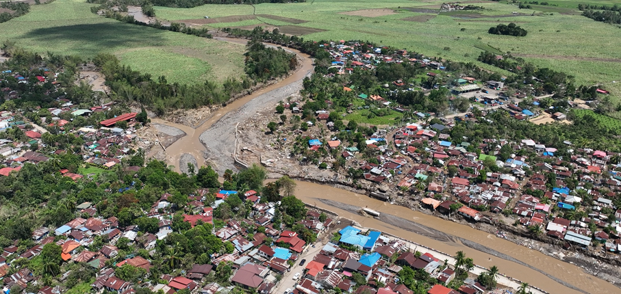
Negros Occidental wordt regelmatig getroffen door overstromingen in de rivierbekkens, en recente (super)tyfoons zoals Tino hebben op grote schaal schade aangericht. De provinciale overheid en de lokale overheden (LGU’s) willen de overstap maken van reactief optreden naar planning en preventie, maar daarvoor is een duidelijk, gedeeld beeld nodig van waar overstromingen plaatsvinden, welke gebieden kwetsbaar zijn en wie het meest kwetsbaar is.
De provincie beschikt al over een sterke gegevensbasis, waaronder een hoogresolutiehoogtemodel, nationale overstromingsgevaarkaarten en een bekwame GIS- en drone-eenheid binnen het Provinciaal Bureau voor Planning en Ontwikkeling. Wat ontbrak, was een gestructureerde manier om deze datasets te combineren tot één consistent beeld van het overstromingsrisico, en de interne capaciteit om daarop voort te bouwen.
Chris Hurink nam deel aan een intensieve DRRS-inzet ter plaatse en werkte samen met het provinciale GIS-team. Het werk was georganiseerd rond de drie componenten van overstromingsrisico’s. Wat blootstelling betreft, heeft het team de bouwoppervlakten bijgewerkt en commerciële, industriële en energielocaties toegevoegd, evenals kritieke infrastructuur zoals wegen en bruggen. Wat gevaar betreft, is het team begonnen met de analyse van overstromingsgevaar, heeft het de beschikbare overstromingslagen op kwaliteit gecontroleerd en deze in het veld gevalideerd. Wat de kwetsbaarheid betreft, verwerkte het team censusgegevens van het Community-Based Monitoring System (CBMS) en koppelde deze aan de gebouwcontouren. Gedurende de hele week werden de vaardigheden van het team versterkt door praktische trainingen in teledetectie, Google Earth Engine en goede gegevenspraktijken, waarbij waar mogelijk gebruik werd gemaakt van geautomatiseerde tools.
provincie Negros Occidental
Countries in Asia and the Pacific region are significantly exposed to disaster risks from various hazards and are on the frontline of a climate emergency. Studies suggest that 80% of the globally affected people belong to the Asia-Pacific region, thus emphasizing the critical need for an effective multi-hazard EWS.
EWS, a cost-effective tool for saving lives and reducing economic losses, is particularly crucial for frequent and hazardous weather, water, and climate events. However, despite advancements in the four EWS components, major gaps persist, with implementation lagging and limited coverage in frontline countries, including least developed countries (LDCs) and small island developing states (SIDS). As of 2021, only 50% of countries in Asia and the Pacific reported having multi-hazard early warning systems (MHEWS), emphasizing the need for support.
The culmination of these efforts will be encapsulated in a scoping report, documenting the results of the project, including consultations with key partners and stakeholders during the Regional Workshop on Increasing Investments in Early Warning Systems, to be held in February 2024 in Bangkok, Thailand. The study will offer a comprehensive summary of the EWS scoping, encompassing the policy and institutional landscape, status, initiatives, and investments, as well as residual gaps for regional and national EWS programming in selected DMCs. Additionally, this study will provide guidelines for the implementation and operationalization of the proposed EWS facility, along with initial investment concept notes based on EWS priorities at regional and/or national levels. This holistic approach aims to contribute substantively to the strengthening of EWS capacities, fostering resilience in the face of increasing disaster risks across the region.
The GEF / UNDP / ASEAN Project on Reducing Pollution and Preserving Environmental Flows in the East Asian Seas through the Implementation of Integrated River Basin Management (IRBM) in the ASEAN Countries is a 5-year project (2023-2027) with the goal of establishing functional IRBM mechanisms in seven priority river basins / sub-basins / watersheds in six ASEAN Member States, to reduce pollution, sustain freshwater environmental flows and adapt to climate change vulnerabilities. The Project is designed to improve governance and management arrangements in IRBM and accelerate the required changes in the six AMS in support of national priorities, objectives and commitments to global sustainable development targets using the Source to Sea (S2S) framework. The PEMSEA Resource Facility (PRF), which serves as the Project Implementing Partner, hosts the Regional Project Management Unit (RPMU). It works in collaboration with National and Local Government Partners and River Basin Organizations.
Component 1 of the Project focuses on the conduct of a baseline assessment of the S2S management continuum with a targeted outcome of improving understanding of governance, socioeconomic, ecological conditions, gaps and needs of priority river basins / sub-basins and coastal areas. This will be achieved through the establishment of the State of River Basin (SORB) reporting system to consolidate information coming from administrative, social, economic and environmental sectors. As an input to the SORB baseline reporting, it is required to complete a comprehensive assessment of competing uses and users of water as a consequence of existing and future water uses and their implications on the water / energy / food / ecosystem (WEFE) security nexus in the priority river basins.
FutureWater is providing this assessment of the WEFE security nexus through review of existing knowledge and literature, stakeholder consultations, as well as tailoring and applying its REWEFe toolkit for nexus analysis to seven river basins in six countries of Southeast Asia: Cambodia, Indonesia, Lao PDR, Malaysia, Philippines and Viet Nam.
The Ridge to Coast, Rain to Tap: Sustainable Water Supply Project (R2CR2T) is an integrated approach to addressing flooding in the Cagayan River basin on Mindanao in the Philippines. R2CR2T is a Public Private Partnership led by VEI together with the partners COWD (Cagayan de Oro Water District), FITC, UTPI/Hineleban Foundation Inc. (HFI), Philippines- and Netherlands Red Cross, Cagayan de Oro River Basin Management Council (CDORBMC), and Wetlands International. R2CR2T is funded by RVO through the Sustainable Water Fund programme.
The Cagayan River Basin is characterized by an upstream mountainous area with steeply sloping terrain towards downstream Cagayan de Oro city. Upstream deforestation and land degradation are known to increase risk of flooding in the city, which is at present already at a high level. One expected outcome of R2CR2T is to have an enabling environment for stakeholders, both private and public sector, to undertake activities related to sustainable land management in the Cagayan River Basin. A Decision Support Tool (DST) for identifying critical areas and approaches for rehabilitation and its benefits regarding flood risk reduction, soil erosion reduction, and enhancing dry season flows, will be developed based on a scientifically-sound hydrological model for the watershed of the Cagayan River.
FutureWater was hired to advise on the development of the DST and hydrological model, critically review the quality and applicability of (intermediate) outputs by the local team and their service providers, and provide an external and international ‘helicopter view’ on the eco-hydrological aspects of the project. In a general sense, FutureWater supports the R2CR2T project team to maximize the impact of the DST will have for the CDORB region and stakeholders.