The study will focus on selection of key traded crops between the EU and Africa and their key producing regions. The tasks will include overall analysis of current practices and the background in the regions, determination of key sensitive parameters in order to select key crops and food products and map hotspot regions. In addition, project team will assess climate risks for these hotspots on key crops and food products and link these risks with the importing countries. Climate risks will be assessed by identifying the multiple climate sensitivities on the food systems in each region, assessing changes predicted by a CMIP6 (latest) climate model ensemble on key agriculture-related climate indices, and analysing impacts on production-related indices, distinguishing between rainfed and irrigated production systems. It will be focused on country specific case studies in each partner country. The impacts of climate change on trade patterns will be evaluated to assess the carbon- and water footprints and virtual water profiles of key traded commodities of these countries. At the end, the project team will focus on policy relevance and assessment of adaptation strategies and identify interventions that will be needed, at which point in the system, and from which sector (or actor) is of interest.

The outcomes of CREATE will be used to increase awareness of the risks that climate change poses to the agro-food trade and the broader economy at large. They can contribute to efforts by the governments (macro-scale), the communities (meso-scale), as well as relevant agricultural producers (micro scale) in the case study countries, by providing essential information for promoting actions towards mitigating the negative consequences of climate change on agro-food trade.

Geodata tools have been developing rapidly in the past years and are vastly adopted by researchers and increasingly by policy-makers. However, the is still great potential to increase the practical application of these tools in the agricultural sector, which is currently applied by a limited number of ‘pioneering’ farmers. The information that can be gained from geodata tools on irrigation management, pest and nutrient management, and crop selection, is a valuable asset for farmers. Key players for providing such information to the farmers are the extensions officers. This project aims at training extension officers in the use of these geodata tools. The beneficiaries in Egypt are: Tamkeen for Advanced Agriculture, FAODA, IDAM, Bio-Oasis, and LEPECHA. The selected participants will receive a training programme which consists firstly of several session on the background and theory of the geodata tools, provided through our online teaching platform (futurewater.moodle.school). Starting from May (2021) field schools will be set up to use the geodata tools for decision-making in these demonstration plots. In addition, modules are taught on the quality of the data, and profitability of such tools. Altogether, a group of carefully selected participants will receive training on these innovative tools and create a bridge to providing this information to farmers specifically the smallholder farmers.

The Middle East and North Africa (MENA) region is considered the most water-scarce region of the world. Disputes over water lead to tension within communities, and unreliable water services are prompting people to migrate in search of better opportunities. Water investments absorb large amounts of public funds, which could often be used more efficiently elsewhere. As the region’s population continues to grow, per capita water availability is set to fall by 50 percent by 2050, and, if climate change affects weather and precipitation patterns as predicted, the MENA region may see more frequent and severe droughts and floods

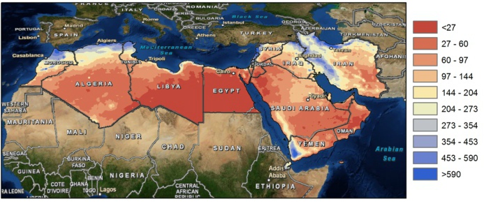
Map of yearly average precipitation in the MENA region (mm).

The need for alternative and improved water management options is therefore urgently needed, but a clear overview on what the main focus should be is lacking. A broad range of options exists which can be grouped by different approaches such as reducing the demand, increasing the supply, transfer between different sectors, transfer within different sectors, increase storage etc. An important aspect for the MENA region includes desalination.

Map of aridity in the MENA region.

To explore different options the World Bank initiated an initiative to generate an improved understanding of water issues in the region and overview of available options under different scenarios of water supply and demand management with special focus on desalination, taking into account the energy nexus and environmental concerns. As part of this initiative, FutureWater will carry out an assessment of water stress in the MENA region, including associated marginal cost of water supply to meet the water supply need. Conducting consultation workshops and meetings will be organized with relevant parties in the region (governmental, universities, civil society groups).

Crop growth models play a major role in sustaining the world-wide food security. These models are used to simulate crop growth during the growing season, and to forecast final crop yields at the end of the growing season. These crop growth models provide the farmer with the option to simulate certain farm management measures (e.g. irrigation frequency, irrigation depth), in order to evaluate the effect of these measures on the final crop yield. Also commodity traders use this information to support their decision making. For accurate crop yield forecasting, crop growth models are highly dependent on the quality of the spatial and temporal input data.

If the uncertainty in the spatial variation of soil properties, initial soil conditions, crop parameters, and meteorological forcing is small, then crop growth models are capable of simulating crop yields quite accurately. Since crop yield forecasting applications are often applied over large areas that rely on a spatially distributed crop growth model, the uncertainty in the spatial variation of the input data increases. This uncertainty is reflected in crop models in the simulation of the crop canopy development, which determines light interception and the potential for photosynthesis. It also influences the simulation of the soil moisture content, which determines the actual transpiration and reduction of photosynthesis as a result of drought stress.

Nowadays, remote sensing images from satellites are often used in crop growth models to improve the simulation of these processes, because remote sensing images provide spatially distributed input data to these models. Data that can be obtained from remote sensing is e.g. the Leaf-Area-Index (LAI), crop yield and biomass. Remote sensing images are available in numerous spatial resolutions, where coarse resolution images are often freely available compared to the more expensive high-resolution images.

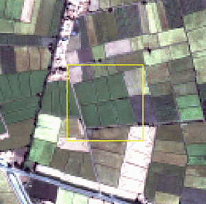
The objective of this project is to evaluate the added value of high-resolution above coarse-resolution remote sensing images in crop yield forecasting. This question is especially relevant if the focus is on small-scale farming where the distribution of crop types is often extremely heterogeneous; meaning that the uncertainty in the spatially distributed model input parameters (soil properties, crop parameters, etc.) becomes larger. FutureWater undertakes this project in collaboration with the Soil Physics and Land Management Group of Wageningen University and eLeaf. For the current study we will use the Soil-Water-Atmosphere-Plant (SWAP) model in combination with LAIs and crop factors (KCs) which were retrieved from remote sensing. Subsequently the SWAP model will be run for i) a representative MODIS pixel (coarse-resolution), containing a mixture of berseem, wheat, build-up area, and another crop, and ii) for 256 ASTER pixels (high-resolution) in which each pixel represents a unique land-use class within that MODIS pixel. The test area for this project is the Meet Yazid command area in Egypt.

The final result of this project will answer the question whether high-resolution remote sensing images in combination with the SWAP model result in improved crop yield forecasts. Moreover the project will generate practical directions to the application of the developed methodology under various conditions including small scale rainfed farmers.

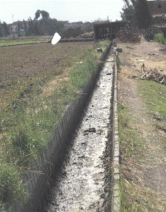
Egypt is modernizing its irrigation systems and management practices from supply-based to demand-based irrigation water supply. The expected result is that farmers will intake less irrigation water, as they are assured that water is continuously available. During this project, the consequence of changing from supply-based irrigation to demand-based irrigation on water availability, crop production, groundwater levels and water quality will be investigated. The impact of significant infrastructure investments on the overall utilization of water resources will be assessed. The outcome is relevant for up-scaling the modernization program towards the entire Nile Delta. The difference between secondary/tertiary units vs. quarternary units will be investigated.

The objective of this study is to carry out an in-depth assessment of the effects of investments in quaternary, tertiary and secondary-level improvements on farmers’ water availability, in terms of quantity, quality, reliability and equity in distribution, and yields of smallholder farmers by studying the winter season 2010/11 and the summer season 2011. Two command areas will be studied: W-10 with, and Daqalt without, modernized quaternary canals. Both command areas comprise about 4,500 farmer households and 2,600 hectare of irrigated land. A suitable third command area without canal modernization will be selected as a reference area.

The assessment will be carried out based on remote sensing analysis and simulation models. A related objective is to facilitate close collaboration with staff of the relevant Egyptian authorities and provide capacity building in the use of the methodological approach for possible subsequent application in other areas of the Nile Delta and beyond where such modernization interventions are being planned. The insights gained on boosting crop production and achieving water savings will feed into the proposed Bank-supported Farm-level Irrigation Modernization Project (FIMP) which aims to modernize farm-level quaternary canals and improve irrigation and cropping practices on 80,000 ha farmed by about 140,000 households in the Nile Delta.

The combined remote sensing and hydrological study will be conducted for 2010/2011. W10 and Daqalt command areas have undergone the modernization process at secondary and tertiary level. The W10 area covers in addition also lifted quarternary canals and has a continuous flow up to the farm gate, so that all farmers have immediate access to irrigation water, in the case they wish so. W10 and Daqalt will be used as a representative area for the new “attitude” of Egyptian irrigators. This attitude will be expressed into consumptive use, head-tail uniformity and crop production.

FutureWater is currently working on the project part on hydrology, using simulation models. We will use the SWAP code to set up field-scale hydrological models to calculate water and salt transport throughout the soil-water-system. We will include transpiration calculations and crop yields. Evapotranspiration estimates will be compared to data from the remote sensing analyses.

The Nile Basin Decision Support System (NBI-DSS) will provide the necessary knowledge base and analytical tools to support the planning of cooperative joint projects and the management of the shared Nile Basin water resources on an equitable, efficient and sustainable manner. FutureWater was asked to support this NBI-DSS and to undertake preliminary data collection and compilation.

Details

The developed data base has two main components: spatial data and point data. Regarding the spatial data the following data have been made available

  • Land cover
  • Soils
  • Vegetation Indices
  • Precipitation FEWS

These data are available over the entire Nile Basin and include a extensive set of attributes. Data have been quality controlled and is ready to apply in the DSS and can be used for various types of hydrological models.

The point data includes over 20 million records from various sources included global and local data sets. Data are stored in PostGreSQL. The data can be considered as the most complete hydro-meteorological dataset available for the Nile so far.

Water shortage is a growing concern and in response to this many countries are developing national water plans in an attempt to allocate water more effectively. In the Middle-East, where water is extremely scarce these water plans are considered as a means to improved water resources planning, but the plans are often based on limited information and data and are always very much focused on water in rivers and groundwater, rather than considering all the components of the water balance in the broader hydrological context. Weaknesses in these water plans often are:

1. Actual water use from irrigated areas is often assumed to be similar to water supplied.
2. There is an emphasis on increasing the so-called water efficiency rather than aiming at increasing water productivity.
3. Water consumption (=evaporation and transpiration) from natural vegetation or bare soils is not considered.
4. Groundwater recharge is poorly understood and based only on groundwater observation wells.
5. Net groundwater use, and to some extent surface water abstraction estimates are based on estimates of pumping hours and pump capacity rather than on actual abstractions.
6. Analysis is based on average conditions.
7. Water plans can be a reflection of preferred policies rather than based on unbiased analyses.

These issues make the estimated water consumption and the, from this derived, potential water allocations often unrealistic. It is however possible by using advanced remote sensing techniques to tackle most of the issues mentioned here. High resolution rainfall observations, accurate evapotranspiration estimates, and biomass production can be obtained at an unprecedented accuracy using remote sensing. Even changes in deep groundwater using changes in gravity fields can be monitored from remote sensing nowadays. Especially the high spatial coverage makes these remote sensing observations a unique product to support the national water plans.

Results based on completed studies in Tunisia, Egypt and Saudi-Arabia using advanced remote sensing techniques, are compared to information used in the national water plans of the three countries. This study assess to what extent these remote sensing observations can support the development of national water plans, improve the understanding of resource availability, better assess where water is consumed, and identify where losses are avoidable.