In Angola, more and better-quality data is required to improve crop suitability assessments over large extensions of arable land to ensure sustainable food and income security. For example, environmental data on soil texture, soil water storage capacity, vegetation growth, terrain slopes, rainfall and air temperature are key to develop reliable crop suitability assessments. These datasets are available from state-of-the-art satellite-based products and machine learning observations (de Boer, 2016; Funk et al., 2015; Hengl et al., 2014, 2017). The benefit of these data products is that data can be obtained for any province, municipality, or farm in Angola. On top of that, data can be shown in maps to easily visualize spatial variation and identify the most suitable location and area to grow desired crops. Land-crop suitability maps are obtained by calculating a weighted average of the environmental variables that influence crop growth (e.g. rainfall, air temperature, soil water storage capacity), providing an integrated and complete assessment on where to plant. Also, potential crop yields are determined for desired cropping seasons using the FAO AquaCrop model to provide more information about potential income.

Irrigated agriculture in Angola has been developed in commercial farms using mainly central pivot and drip irrigation systems. The installation of new irrigation systems is foreseen in large extensions of land over 5000 hectares. Irrigated agriculture results in higher crop yields and allows higher incomes to farmers. However, commercial farms must invest in high energy supply to operate irrigation systems with water pumping stations. The challenge for irrigation system operators is to know exactly when and how much to irrigate during the cropping season. If better information about irrigation volumes and intervals are provided a significal reduction in energy costs could be achieved. The objective is to predict irrigation demand volumes during the cropping season and provide a user-friendly decision tool to irrigation operators. To achieve this, weather forecasts, remote sensing, and the SPHY model will be used.
The Government of Angola is developing a policy to diversify the country’s economy, strongly dependent on the income of the oil sector. Agriculture is considered one of the priority sectors to be developed. A favorable climate and a relatively high availability of water resources and fertile soils, can lead Angola to become one of the leaders in agricultural production of the African continent.

With the objective of increasing agricultural production and productivity and favoring investment and innovation in related businesses, the present project arises: a nexus between policies, practice and knowledge. The project “Knowledge-to-Knowledge (K2K – Knowledge to Knowledge), funded by the Dutch government and managed by the University of Wageningen, aims to strengthen and enhance the capacity of the main Angolan knowledge institutions in agricultural sciences, to establish a strong relate between knowledge and practice. To do this, the development of skills in Geographic Information Technologies of the Faculty of Agricultural Sciences (FCA) of the José Eduardo dos Santos de Huambo University (UJES) is proposed.

Among other tasks, a program is established with an approach based on “Train the Trainers -TtT” (train the trainers), in which FutureWater has collaborated, with the aim of developing the knowledge and skills of the FCA staff. UJES in Geoinformatics and Remote Sensing. After the development of the TtT program, the staff of the University should be able to:

  1. Establish a University program of training in Remote Sensing
  2. Develop and maintain the necessary teaching material
  3. Initiate and carry out its own research program
  4. Develop small courses aimed at the agricultural sector

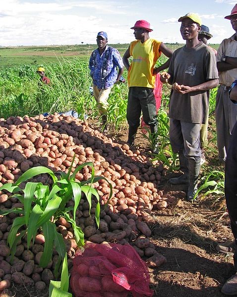
The government of Angola considers the agricultural sector as an economic sector that offers great prospects and therefore aims to further develop the agricultural sector in order to diversify its economy. The potential for expanding the area under production is great. The country has fertile soils, a favorable climate, sufficient water resources and abundant unexploited land. Specifically, the province of Huambo is mentioned as one of the most promising areas for a growing agricultural sector.

Potato farmers in Huambo (Wikipedia).

Currently, the Angolan agricultural sector is characterized by low productivity and low competitiveness. To support the effective planning of interventions that increase production and expand the agricultural sector, reliable information is crucial. The reliability of the existing data on agricultural production in Angola is unclear. Additionally, there is no insight in which regions of unexploited lands would show the highest potential yields if put into production. Therefore, the uncertainty related to investing in new land resources is high.

This pilot project focuses on the use of remote sensing for providing relevant data and information to support effective decision making and planning for the expansion of the Angolan agricultural sector.

The general purpose of the project is the development and application of remote-sensing based products that support planning and monitoring of agricultural development, and the assessment of the potential of agricultural areas for three selected crops.

The specific objectives of this pilot project are to provide the Institute for Agricultural Development (IDA) and the Faculty of Agricultural Sciences of the José Eduardo dos Santos University (UJES-FCA) with:

  1. Information on trends (of the past 10 years) in land use and land development and insight in the reliability of historical statistical data;
  2. An agro-ecological potential map for the province of Huambo for 3 crops;
  3. A tentative map showing irrigation potential in the Province of Huambo