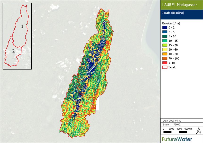
Within the Land Use Planning for Enhanced Resilience of Landscapes (LAUREL) project commissioned by the World Bank, a Land Use Change Simulation Platform (LANDSIM-P) has been developed by FutureWater and partners. The objective of LANDSIM-P is to support policy makers in Madagascar by providing an integrated assessment of the impact of current and future land use and land management on the status and risk of land degradation and land-based ecosystem services. Part of the LANDSIM-P instrument is a decision support tool at the regional level, which is used to simulate water availability and erosion under different scenarios related to sustainable land management (SLM) activities and land use change. This regional-scale toolbox (LANDSIM-Regional, or LANDSIM-R) supports SLM planning processes within the $80-million Sustainable Landscape Management Project (PADAP).
FutureWater has configured five catchment models with LANDSIM-R and provided capacity building to PADAP staff in using LANDSIM-R, evaluating its results in a SLM planning context, and updating and improving the toolbox with additional data. Currently, FutureWater is analyzing soil erosion and hydrological processes in these five catchments, to help spatialize the intended PADAP investments. Soil erosion hotspots, potential impact of SLM interventions (reforestation, forest conservation, terracing, agroforestry conservation agriculture), and downstream effects on sediment yield and water availability, are evaluated with LANDSIM-R in cooperation with local PADAP experts. In this way, LANDSIM-R supports implementation of SLM in Madagascar.