
Concept
SPHY (Spatial Processes in Hydrology) is a conceptual, spatially distributed (raster-based) “leaky-bucket” type water balance model. The model integrates dominant hydrological processes like (i) rainfall–runoff; (ii) lake/reservoir outflow, (iii) cryospheric processes (snow, ice, glaciers) (iv) evapotranspiration and (v) soil hydrological processes. The SPHY model has been developed and updated overtime by combining the best components of existing and well tested simulation models: SRM, VIC, HydroS, SWAT, PCR-GLOBWB, SWAP and HimSim. SPHY includes relevant terrestrial hydrological processes at flexible scales (local, regional and global), under various land use change, extreme weather and climate scenarios. An overview of the SPHY model concepts is shown in the Figure 1.
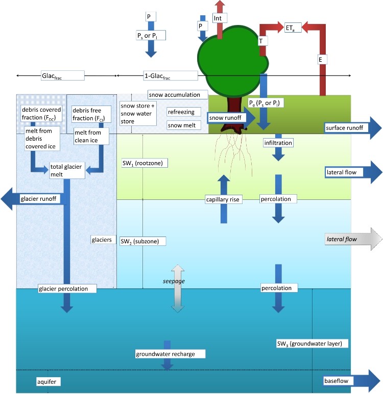
Mass conservation is main underlying concept used in the SPHY model. The dominant hydrological processes are defined by the physical sets of equation and parameters. SPHY uses a sub grid variability approach for the proper representation of the processes acting at finer spatial scales. A cell can be glacier-free, partially glacierized, or completely covered by glaciers. The non-glacierized cell can be of different landuse type. Sub-grid variability is mainly determined by the fractional vegetation coverage, which affects processes such as interception, effective precipitation, and potential evapotranspiration.
The soil/land column is divided in two upper soil stores and a third groundwater store, with their corresponding drainage components: surface runoff, lateral flow and base flow. Melting of glacier ice contributes to the river discharge by means of a slow and fast component, being (i) percolation to the groundwater reservoir that eventually becomes base flow, and (ii) direct runoff.
The model simulates the dynamic behavior of the glaciers by incorporating key processes such as accumulation, ablation and ice mass transfer from accumulation to ablation zone. If glacier is losing mass, ice from the ablation zone will be redistributed over the ablation zone according to the volume ice redistribution.
Further, SPHY includes lake module which keeps track of the lake level height and storage at each time step of the model simulation. The lake module uses an advance scheme to route the flow from lake cells to the downstream regions. Additionally, SPHY uses erosion module which calculates the soil erosion due to the impact of raindrops, overland flow, and river flow.
There is no best model available which is adequate for all types of applications. The choice of model is driven by the overall objective of the project. However, SPHY stands out as compared to other models due to its wide range of functionalities such as:
Spatial scale
SPHY model can be applied to flexible ranges of spatial scales such as small-scale farm, medium scale sub-catchment and catchment, and large scale regional and global applications. SPHY helps the user to better understand the spatial differences and variability of the key hydrological process. Further, the model can be run on different spatial scales for different processes within the same simulation. For instance, the glacier can be run on 50 meters resolution while the model resolution is 1000 meters.
Temporal scale
SPHY model can be applied from sub-daily to daily, weekly, monthly and yearly time steps depending on the daily variations of the key hydrological processes and data availability.
Adaptability
SPHY model can be easily adapted for the use in different climatic conditions around the world. This is very useful if the user is studying hydrological processes in regions where not all hydrological processes are relevant. A user may for example be interested in studying irrigation water requirements in central Africa. For this region glacier and snow melting processes are irrelevant and can thus be switched off. Another user may only be interested in simulating moisture conditions in the first soil layer, allowing the possibility to switch off the routing and groundwater modules.
Data requirement
A user can use any of ground-based observations such as hydrological data: discharge, cryospheric data: snow cover, glacier mass balance, crop data: crop coefficients static, leaf area index, lake and reservoir information etc., if available to better represent and improve the accuracy of the model. The model can be supplied with data on a parsimonious and data hungry approach depending on the data availability in the region.
User friendliness
SPHY model is user-friendly and can be applied by anyone having a general knowledge on key hydrological processes. A static constant or stochastic time series or a more complex raster maps can be provided as inputs to the model as specified by the user. Further, SPHY model provides a wealth of output data that can be selected based on the preference of the user. Spatial output can be presented as spatial maps of all the hydrological processes. These maps can be generated on daily base, but also the aggregates at monthly or annual time periods. Time-series can be generated for each location in the study area as specified by the user.
FutureWater applications
FutureWater employs SPHY model in various contexts and applications. The model of choice depends on each project and analysis required. Following are the key areas of the SPHY model application.
Past and future hydrological changes
SPHY has been applied on numerous projects to assess the historic hydrological regimes and the future changes in it. The model has been used in HICAP and HI-AWARE projects to understand the key aspects of the historical and future changes in hydrological regimes of major river basins in south east Asia and central Asia. Further, HI-AWARE project explores the changes in hydro-climatic extremes (floods and droughts) in the region. Moreover in PanTPE, SPHY is used to explore the changes in climate for green development of the Silk Road Economic Belt (SREB) in the Third-Pole region.
Basin management
SPHY has been used in this ‘Strategic Basin Planning Ganga River Basin’ project to understand the surface-groundwater interactions across the basin to refine the river modelling. The project uses a multi-scale environmental flow information across the basin and use these assessments to provide feedback to scenario modelling. Project also explores a series of plausible scenarios that explore alternative options for improving water management including improving river health using SPHY.
Irrigation management
SPHY has been applied with the purpose of providing field specific irrigation advice for a small-scale farm in countries like western Romania and Angola. The basis for this system is formed by online in-situ ground data on soil moisture content and SPHY calculations of the root zone and shallow subsoil.
Flow forecasting
SPHY has been applied for the operational flow forecasting purpose in a catchment in Chile. In this project, SPHY has been used in an integrated system, which used measurements derived from both Earth observation satellites and in situ sensors, to forecast seasonal streamflow during the snow melting season.
Land degradation and restoration
SPHY has been used in Madagascar for integrated decision making for landscape management in Madagascar through improved spatial data on land degradation, and through the development of prototype platforms for simulating, evaluating, and re-orienting as appropriate, land use and land use change processes.
Energy
SPHY has been used in several countries Georgia, Indonesia, Kenya, Tanzania, Nepal to assess the changes in future stream flows for the hydropower development. These projects explore the landuse and climate change impact on the stream flows to be used further by the hydropower developers to assess the technical and financial feasibility of the projects under changing climate.
Hydroclimatic extremes and compound events
SPHY model has been used in several scientific research projects like SYSTEM-RISK and IMPREX to explore a systems approach for large-scale flood risk assessment and management due to compound extreme events.
For more information regarding the project and other application please visit http://www.sphy.nl/.
